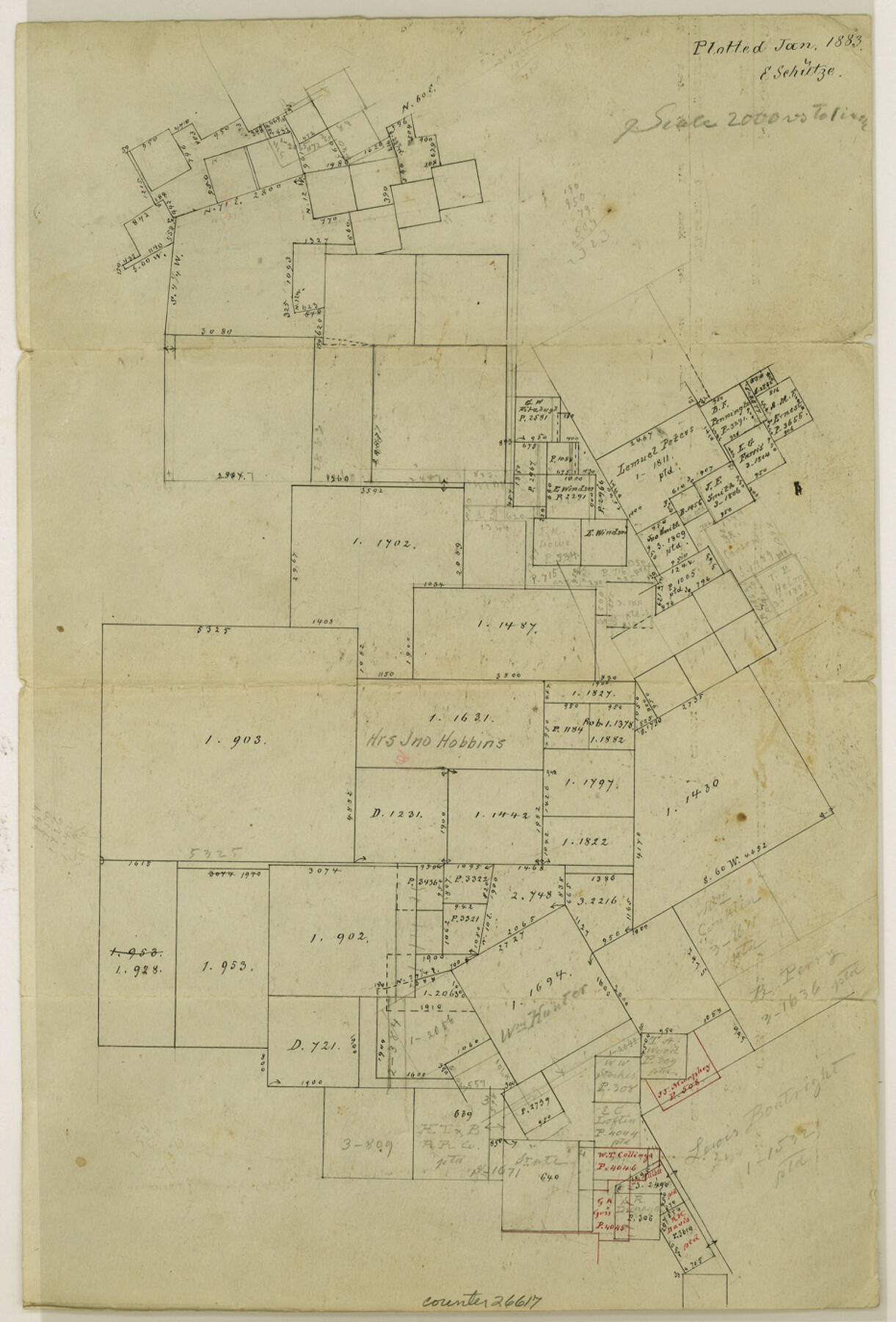
Hood County Sketch File 22a
[Sketch of surveys around the John Hobbins tract in western part of county]
-
Map/Doc
26617
-
Collection
General Map Collection
-
Object Dates
1/1883 (File Date)
-
People and Organizations
E. Schutze (Draftsman)
-
Counties
Hood Erath
-
Subjects
Surveying Sketch File
-
Height x Width
13.7 x 9.3 inches
34.8 x 23.6 cm
-
Medium
paper, manuscript
-
Scale
1" = 2000 varas
Part of: General Map Collection
Hall County Rolled Sketch D2

Print $20.00
- Digital $50.00
Hall County Rolled Sketch D2
Size 19.0 x 22.1 inches
Map/Doc 6055
Frio County Working Sketch 4

Print $20.00
- Digital $50.00
Frio County Working Sketch 4
1924
Size 26.4 x 27.2 inches
Map/Doc 69278
Donley County

Print $20.00
- Digital $50.00
Donley County
1944
Size 43.6 x 37.7 inches
Map/Doc 77266
Current Miscellaneous File 21

Print $26.00
- Digital $50.00
Current Miscellaneous File 21
1952
Size 10.8 x 8.2 inches
Map/Doc 73865
Harris County Rolled Sketch 42

Print $20.00
- Digital $50.00
Harris County Rolled Sketch 42
1919
Size 15.7 x 19.5 inches
Map/Doc 6100
Duval County Rolled Sketch OS

Print $20.00
- Digital $50.00
Duval County Rolled Sketch OS
1903
Size 36.0 x 31.9 inches
Map/Doc 8803
Edwards County Rolled Sketch 32

Print $20.00
- Digital $50.00
Edwards County Rolled Sketch 32
1986
Size 36.7 x 24.3 inches
Map/Doc 8850
Mills County Working Sketch 27

Print $20.00
- Digital $50.00
Mills County Working Sketch 27
2000
Size 37.3 x 47.3 inches
Map/Doc 71057
Somervell County

Print $20.00
- Digital $50.00
Somervell County
1941
Size 28.1 x 26.1 inches
Map/Doc 73291
Brazoria County Sketch File 25

Print $8.00
- Digital $50.00
Brazoria County Sketch File 25
1875
Size 8.4 x 13.2 inches
Map/Doc 15024
Red River County Working Sketch 77

Print $20.00
- Digital $50.00
Red River County Working Sketch 77
1981
Size 34.9 x 23.8 inches
Map/Doc 72060
Flight Mission No. BRA-16M, Frame 86, Jefferson County

Print $20.00
- Digital $50.00
Flight Mission No. BRA-16M, Frame 86, Jefferson County
1953
Size 18.5 x 22.3 inches
Map/Doc 85698
You may also like
General Highway Map, Dawson County, Texas

Print $20.00
General Highway Map, Dawson County, Texas
1940
Size 18.5 x 25.2 inches
Map/Doc 79071
San Patricio County Sketch File 36

Print $26.00
- Digital $50.00
San Patricio County Sketch File 36
1940
Size 11.3 x 8.7 inches
Map/Doc 36129
The United States of Mexico

Print $20.00
- Digital $50.00
The United States of Mexico
1832
Size 15.4 x 12.8 inches
Map/Doc 93952
Flight Mission No. BRA-6M, Frame 143, Jefferson County

Print $20.00
- Digital $50.00
Flight Mission No. BRA-6M, Frame 143, Jefferson County
1953
Size 18.5 x 22.2 inches
Map/Doc 85444
Panola County Rolled Sketch 1

Print $20.00
- Digital $50.00
Panola County Rolled Sketch 1
Size 17.5 x 23.9 inches
Map/Doc 7196
Travis County Sketch File 2

Print $4.00
- Digital $50.00
Travis County Sketch File 2
1851
Size 8.2 x 9.9 inches
Map/Doc 38271
Sketch H Showing the progress of the Survey in Section No. 8

Print $20.00
- Digital $50.00
Sketch H Showing the progress of the Survey in Section No. 8
1846
Size 17.1 x 20.6 inches
Map/Doc 97222
[Blocks A, B and C]
![89867, [Blocks A, B and C], Twichell Survey Records](https://historictexasmaps.com/wmedia_w700/maps/89867-1.tif.jpg)
Print $40.00
- Digital $50.00
[Blocks A, B and C]
Size 36.0 x 59.0 inches
Map/Doc 89867
Parker County Working Sketch 17

Print $20.00
- Digital $50.00
Parker County Working Sketch 17
1996
Map/Doc 71467
Map of Archer County

Print $20.00
- Digital $50.00
Map of Archer County
1886
Size 24.4 x 20.5 inches
Map/Doc 3240
United States Atlantic and Gulf Coasts Including Puerto Rico and the Virgin Islands

Print $40.00
- Digital $50.00
United States Atlantic and Gulf Coasts Including Puerto Rico and the Virgin Islands
1973
Size 21.9 x 60.6 inches
Map/Doc 76125
Henderson County Boundary File 2a

Print $12.00
- Digital $50.00
Henderson County Boundary File 2a
Size 14.2 x 8.8 inches
Map/Doc 54656