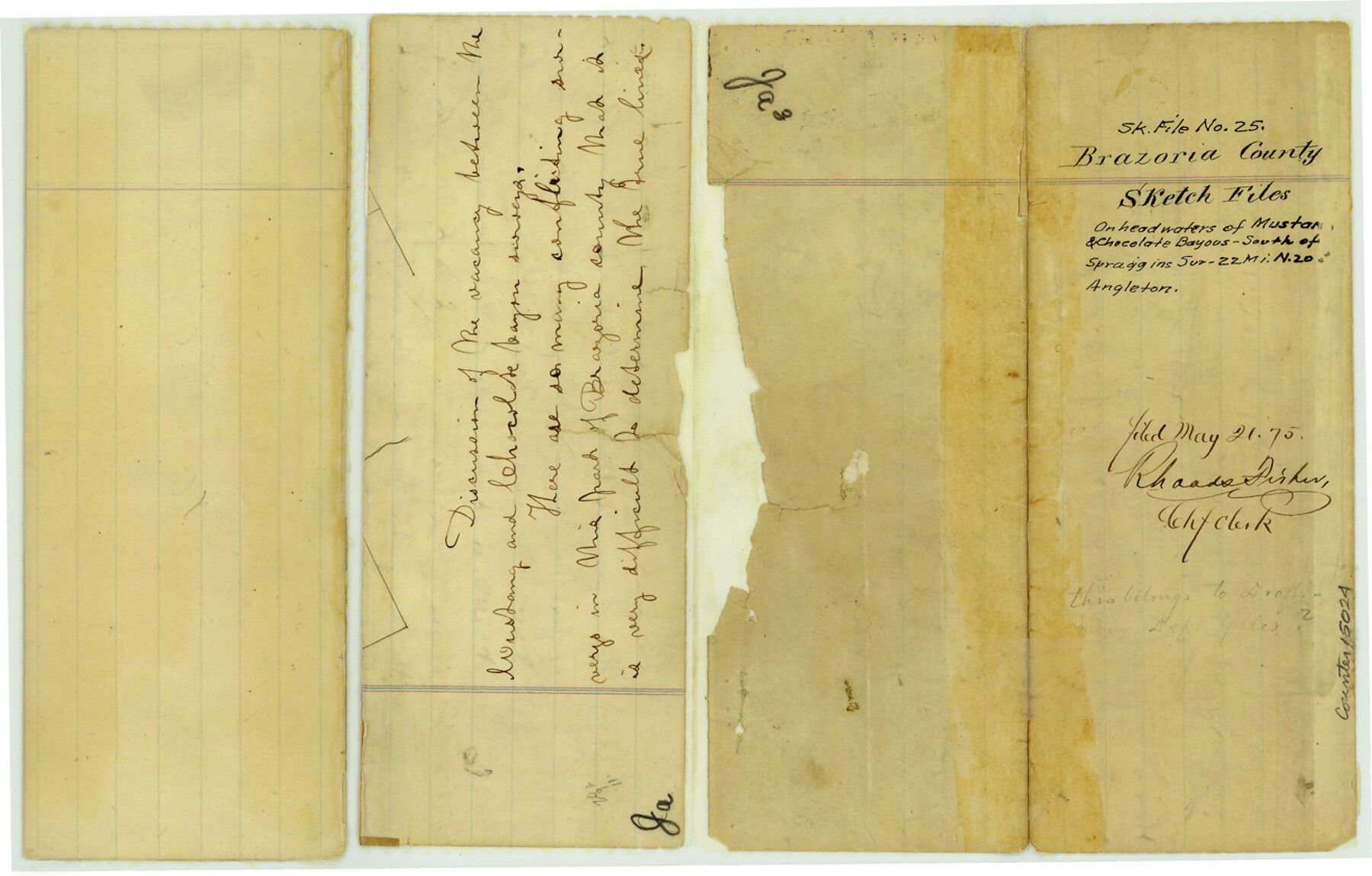
Brazoria County Sketch File 25
[Sketch and statement relating to surveys in the area of Mustang Bayou and Chocolate Bayou south of the Thos. Spraggins survey]
-
Map/Doc
15024
-
Collection
General Map Collection
-
Object Dates
1875/5/15 (Creation Date)
1875/5/21 (File Date)
-
People and Organizations
Hennell Stevens (Surveyor/Engineer)
-
Counties
Brazoria
-
Subjects
Surveying Sketch File
-
Height x Width
8.4 x 13.2 inches
21.3 x 33.5 cm
-
Medium
paper, manuscript
-
Features
Mustang Bayou
Chocolate Bayou
Part of: General Map Collection
Midland County Boundary File 3

Print $4.00
- Digital $50.00
Midland County Boundary File 3
Size 8.2 x 8.3 inches
Map/Doc 57174
Jeff Davis County Working Sketch 34

Print $20.00
- Digital $50.00
Jeff Davis County Working Sketch 34
1978
Size 20.4 x 38.0 inches
Map/Doc 66529
Hunt County Working Sketch 6

Print $20.00
- Digital $50.00
Hunt County Working Sketch 6
1942
Size 31.0 x 40.3 inches
Map/Doc 66353
Potter County Working Sketch 2

Print $40.00
- Digital $50.00
Potter County Working Sketch 2
1919
Size 43.3 x 54.4 inches
Map/Doc 71662
[Surveys along Sims Bayou]
![156, [Surveys along Sims Bayou], General Map Collection](https://historictexasmaps.com/wmedia_w700/maps/156.tif.jpg)
Print $2.00
- Digital $50.00
[Surveys along Sims Bayou]
1842
Size 8.6 x 6.2 inches
Map/Doc 156
Live Oak County Sketch File 13

Print $17.00
- Digital $50.00
Live Oak County Sketch File 13
1880
Size 10.2 x 13.7 inches
Map/Doc 30270
Nueces County Sketch File 33

Print $20.00
- Digital $50.00
Nueces County Sketch File 33
1908
Size 22.0 x 19.2 inches
Map/Doc 42188

Runnels County Sketch File 18

Print $10.00
Runnels County Sketch File 18
1892
Size 14.0 x 8.4 inches
Map/Doc 35476
Il Cuscho Citta Principale Della Provincia del Peru

Print $20.00
- Digital $50.00
Il Cuscho Citta Principale Della Provincia del Peru
1592
Size 12.3 x 15.4 inches
Map/Doc 97026
Hudspeth County Sketch File 34

Print $12.00
- Digital $50.00
Hudspeth County Sketch File 34
1944
Size 11.2 x 8.8 inches
Map/Doc 26997
Flight Mission No. BQR-7K, Frame 30, Brazoria County

Print $20.00
- Digital $50.00
Flight Mission No. BQR-7K, Frame 30, Brazoria County
1952
Size 18.6 x 22.3 inches
Map/Doc 84028
You may also like
Jefferson County NRC Article 33.136 Sketch 1

Print $20.00
- Digital $50.00
Jefferson County NRC Article 33.136 Sketch 1
2002
Size 24.0 x 36.1 inches
Map/Doc 61601
Duval County Working Sketch 45

Print $20.00
- Digital $50.00
Duval County Working Sketch 45
1979
Size 29.7 x 30.8 inches
Map/Doc 68769
Calhoun County Rolled Sketch 22

Print $20.00
- Digital $50.00
Calhoun County Rolled Sketch 22
Size 35.0 x 37.0 inches
Map/Doc 8552
Map of the country adjacent to the left bank of the Rio Grande below Matamoros

Print $20.00
- Digital $50.00
Map of the country adjacent to the left bank of the Rio Grande below Matamoros
1847
Size 18.3 x 27.5 inches
Map/Doc 72867
[Area north of Leagues 1 & 4, Morris County School Land]
![90353, [Area north of Leagues 1 & 4, Morris County School Land], Twichell Survey Records](https://historictexasmaps.com/wmedia_w700/maps/90353-1.tif.jpg)
Print $20.00
- Digital $50.00
[Area north of Leagues 1 & 4, Morris County School Land]
Size 21.3 x 16.0 inches
Map/Doc 90353
Gray County Boundary File 3a

Print $4.00
- Digital $50.00
Gray County Boundary File 3a
Size 14.2 x 8.8 inches
Map/Doc 53874
Wilbarger County Sketch File 29

Print $18.00
- Digital $50.00
Wilbarger County Sketch File 29
2016
Size 11.0 x 8.5 inches
Map/Doc 95325
Freestone County Sketch File 9

Print $4.00
- Digital $50.00
Freestone County Sketch File 9
1859
Size 7.9 x 8.3 inches
Map/Doc 23056
Garza County Rolled Sketch 5A

Print $40.00
- Digital $50.00
Garza County Rolled Sketch 5A
Size 36.4 x 53.8 inches
Map/Doc 3830
Concho County Sketch File 42

Print $8.00
- Digital $50.00
Concho County Sketch File 42
1948
Size 14.4 x 8.9 inches
Map/Doc 19200
Dimmit County Sketch File 44

Print $20.00
- Digital $50.00
Dimmit County Sketch File 44
Size 16.3 x 19.5 inches
Map/Doc 11354
Gaines County Rolled Sketch 2

Print $40.00
- Digital $50.00
Gaines County Rolled Sketch 2
1901
Size 23.3 x 70.9 inches
Map/Doc 9012