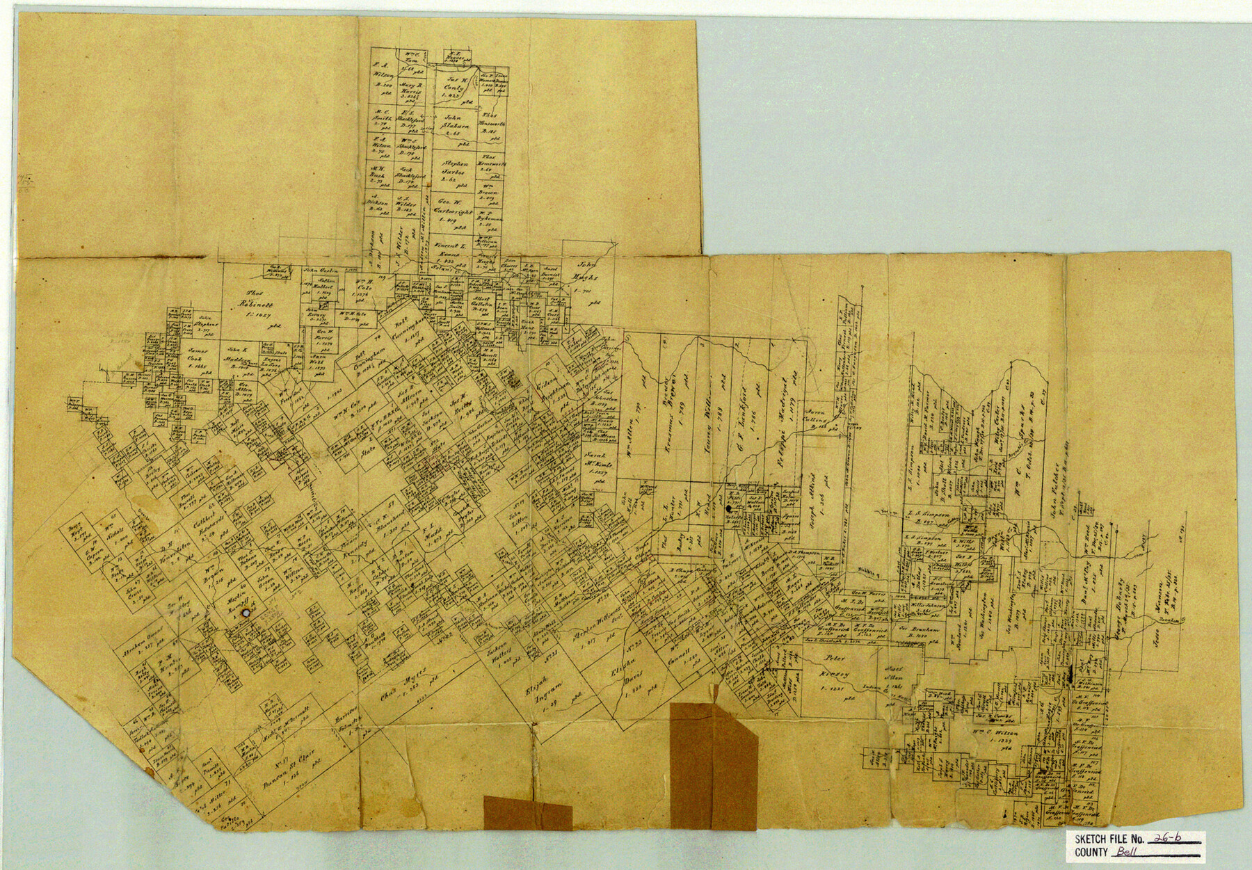
Bell County Sketch File 26b
[Office sketch of the southwest 1/4 of county]
-
Map/Doc
10917
-
Collection
General Map Collection
-
Counties
Bell
-
Subjects
Surveying Sketch File
-
Height x Width
14.7 x 21.1 inches
37.3 x 53.6 cm
-
Medium
paper, manuscript
-
Features
Solan's Creek
Reynold's Creek
Darr's Creek
Cottage Creek
Middle Fork of Darr's Creek
Mustang Creek
Buris Creek
Deer Creek
Mill Creek
Donahoe Creek
Trimmlee's Creek
Reese's Creek
Indian Creek North
South Fork of Darr's Creek
North Fork of Darr's Creek
Part of: General Map Collection
Wharton County Sketch File 3

Print $4.00
- Digital $50.00
Wharton County Sketch File 3
1875
Size 9.1 x 8.3 inches
Map/Doc 39915
Bowie County Sketch File 8

Print $42.00
- Digital $50.00
Bowie County Sketch File 8
1927
Size 8.9 x 3.8 inches
Map/Doc 14872
Dimmit County Rolled Sketch 22A

Print $20.00
- Digital $50.00
Dimmit County Rolled Sketch 22A
2012
Size 23.2 x 34.0 inches
Map/Doc 93630
San Augustine County Working Sketch 5

Print $20.00
- Digital $50.00
San Augustine County Working Sketch 5
1935
Size 39.0 x 37.4 inches
Map/Doc 63692
Calhoun County Rolled Sketch 23

Print $40.00
- Digital $50.00
Calhoun County Rolled Sketch 23
1967
Size 31.1 x 67.0 inches
Map/Doc 8553
Crane County Boundary File 1

Print $6.00
- Digital $50.00
Crane County Boundary File 1
Size 14.1 x 8.7 inches
Map/Doc 51957
Crockett County Rolled Sketch 32

Print $20.00
- Digital $50.00
Crockett County Rolled Sketch 32
1930
Size 44.8 x 34.5 inches
Map/Doc 8697
Flight Mission No. CLL-3N, Frame 19, Willacy County

Print $20.00
- Digital $50.00
Flight Mission No. CLL-3N, Frame 19, Willacy County
1954
Size 18.4 x 22.1 inches
Map/Doc 87085
Nueces County Rolled Sketch 27A

Print $40.00
- Digital $50.00
Nueces County Rolled Sketch 27A
1946
Size 11.6 x 52.4 inches
Map/Doc 76042
Hudspeth County Working Sketch 49

Print $20.00
- Digital $50.00
Hudspeth County Working Sketch 49
1984
Size 29.8 x 28.1 inches
Map/Doc 66334

Newton County Sketch File 4c

Print $4.00
- Digital $50.00
Newton County Sketch File 4c
Size 7.4 x 8.2 inches
Map/Doc 32366
You may also like
Flight Mission No. CRC-1R, Frame 35, Chambers County

Print $20.00
- Digital $50.00
Flight Mission No. CRC-1R, Frame 35, Chambers County
1956
Size 18.9 x 22.5 inches
Map/Doc 84703
Map of Dewitt County, Texas

Print $20.00
- Digital $50.00
Map of Dewitt County, Texas
Size 22.8 x 27.6 inches
Map/Doc 706
Travis County Boundary File 1

Print $8.00
- Digital $50.00
Travis County Boundary File 1
Size 9.0 x 14.6 inches
Map/Doc 59403
Nueces County Rolled Sketch 100

Print $20.00
- Digital $50.00
Nueces County Rolled Sketch 100
Size 30.6 x 40.7 inches
Map/Doc 10209
Baker Addition to Lamesa, Part of Southwest Quarter Section 71, Block 35

Print $20.00
- Digital $50.00
Baker Addition to Lamesa, Part of Southwest Quarter Section 71, Block 35
Size 23.8 x 19.5 inches
Map/Doc 92576
Hardin County Working Sketch 17

Print $20.00
- Digital $50.00
Hardin County Working Sketch 17
1942
Size 18.4 x 12.6 inches
Map/Doc 63415
Flight Mission No. BRA-7M, Frame 17, Jefferson County

Print $20.00
- Digital $50.00
Flight Mission No. BRA-7M, Frame 17, Jefferson County
1953
Size 18.6 x 22.4 inches
Map/Doc 85468
Rusk County Sketch File 38

Print $6.00
Rusk County Sketch File 38
1951
Size 11.3 x 8.8 inches
Map/Doc 35576
Reagan County Working Sketch 38

Print $40.00
- Digital $50.00
Reagan County Working Sketch 38
1969
Size 60.8 x 30.5 inches
Map/Doc 71880
[Sketch of Survey 152, Block 9]
![93095, [Sketch of Survey 152, Block 9], Twichell Survey Records](https://historictexasmaps.com/wmedia_w700/maps/93095-1.tif.jpg)
Print $2.00
- Digital $50.00
[Sketch of Survey 152, Block 9]
Size 5.1 x 6.3 inches
Map/Doc 93095
King County Working Sketch 6

Print $20.00
- Digital $50.00
King County Working Sketch 6
1944
Size 11.5 x 18.3 inches
Map/Doc 70170
Stonewall County Rolled Sketch 11

Print $20.00
- Digital $50.00
Stonewall County Rolled Sketch 11
Size 33.2 x 28.1 inches
Map/Doc 7867