Culberson County Sketch File 13a
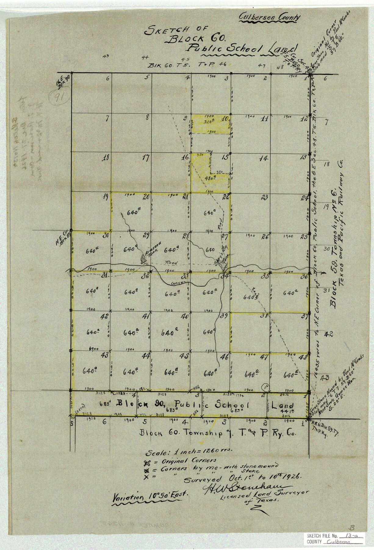
Sketch of Block 60 Public School Land
-
Map/Doc
11265
-
Collection
General Map Collection
-
Object Dates
1926 (Creation Date)
1926/12/27 (File Date)
-
People and Organizations
H.W. Stoneham (Surveyor/Engineer)
-
Counties
Culberson
-
Subjects
Surveying Sketch File
-
Height x Width
20.7 x 14.1 inches
52.6 x 35.8 cm
-
Medium
paper, manuscript
-
Scale
1" = 1260 varas
-
Features
Seay's Big Tank
Part of: General Map Collection
San Patricio County Rolled Sketch 46

Print $20.00
- Digital $50.00
San Patricio County Rolled Sketch 46
1983
Size 19.6 x 25.5 inches
Map/Doc 7730
Brewster County Sketch File N-29

Print $6.00
- Digital $50.00
Brewster County Sketch File N-29
1969
Size 14.1 x 8.8 inches
Map/Doc 15705
Crosby County Sketch File 16

Print $20.00
- Digital $50.00
Crosby County Sketch File 16
1904
Size 31.7 x 9.6 inches
Map/Doc 11251
Flight Mission No. DIX-6P, Frame 186, Aransas County

Print $20.00
- Digital $50.00
Flight Mission No. DIX-6P, Frame 186, Aransas County
1956
Size 19.2 x 22.9 inches
Map/Doc 83848
Harris County Working Sketch 47

Print $40.00
- Digital $50.00
Harris County Working Sketch 47
1942
Size 39.5 x 51.9 inches
Map/Doc 65939
Real County Working Sketch 90

Print $20.00
- Digital $50.00
Real County Working Sketch 90
1991
Size 16.7 x 22.8 inches
Map/Doc 71982
Galveston County Rolled Sketch 24

Print $20.00
- Digital $50.00
Galveston County Rolled Sketch 24
1973
Size 28.1 x 25.6 inches
Map/Doc 5958
Throckmorton County Working Sketch 8

Print $20.00
- Digital $50.00
Throckmorton County Working Sketch 8
1958
Size 21.6 x 30.4 inches
Map/Doc 62117
Bastrop County

Print $20.00
- Digital $50.00
Bastrop County
1883
Size 25.9 x 25.2 inches
Map/Doc 3276
Bee County Working Sketch 6

Print $20.00
- Digital $50.00
Bee County Working Sketch 6
1934
Size 33.8 x 24.1 inches
Map/Doc 67256
Borden County Working Sketch 12

Print $20.00
- Digital $50.00
Borden County Working Sketch 12
1956
Size 43.1 x 37.0 inches
Map/Doc 67472
Lamar County Working Sketch 10

Print $20.00
- Digital $50.00
Lamar County Working Sketch 10
1980
Size 18.6 x 15.4 inches
Map/Doc 70271
You may also like

Wise County Sketch File 5

Print $6.00
- Digital $50.00
Wise County Sketch File 5
1856
Size 8.2 x 14.0 inches
Map/Doc 40531
Hartley County Sketch File 18

Print $4.00
- Digital $50.00
Hartley County Sketch File 18
2001
Size 11.1 x 8.7 inches
Map/Doc 76330
Erath County Working Sketch 21

Print $20.00
- Digital $50.00
Erath County Working Sketch 21
1965
Size 23.9 x 19.8 inches
Map/Doc 69102

Pecos County Rolled Sketch 185

Print $20.00
- Digital $50.00
Pecos County Rolled Sketch 185
1985
Size 34.9 x 29.0 inches
Map/Doc 7304

Palo Pinto County Working Sketch 27

Print $20.00
- Digital $50.00
Palo Pinto County Working Sketch 27
2006
Map/Doc 83609
Garza County Working Sketch 9

Print $20.00
- Digital $50.00
Garza County Working Sketch 9
1952
Size 15.7 x 18.0 inches
Map/Doc 63156
Parker County Working Sketch 22

Print $20.00
- Digital $50.00
Parker County Working Sketch 22
2007
Map/Doc 88607

Gulf Coast of the United States, Key West to Rio Grande

Print $20.00
- Digital $50.00
Gulf Coast of the United States, Key West to Rio Grande
1863
Size 18.3 x 27.2 inches
Map/Doc 72667