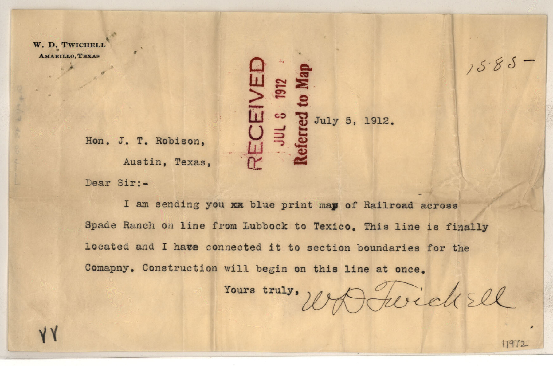
Lamb County Sketch File 10
[Sketch connecting section boundaries to railroad line across Spade Ranch in southeast corner of the county]
-
Map/Doc
11972
-
Collection
General Map Collection
-
Object Dates
7/5/1912 (Creation Date)
7/8/1912 (File Date)
-
People and Organizations
W.D. Twichell (Surveyor/Engineer)
-
Counties
Lamb Hockley Lubbock Hale
-
Subjects
Surveying Sketch File
-
Height x Width
20.0 x 31.2 inches
50.8 x 79.3 cm
-
Medium
multi-page, multi-format
-
Features
Spade Ranch
Lubbock
Texico
Yellow House Creek
P&NT
Part of: General Map Collection
Lampasas County Sketch File 18

Print $4.00
- Digital $50.00
Lampasas County Sketch File 18
Size 8.1 x 4.8 inches
Map/Doc 29430
Val Verde County Sketch File XXX

Print $30.00
- Digital $50.00
Val Verde County Sketch File XXX
1908
Size 39.2 x 24.6 inches
Map/Doc 10424
Crosby County Boundary File 1

Print $20.00
- Digital $50.00
Crosby County Boundary File 1
Size 7.4 x 4.1 inches
Map/Doc 51971
Andrews County Working Sketch 23

Print $20.00
- Digital $50.00
Andrews County Working Sketch 23
1979
Size 26.6 x 27.7 inches
Map/Doc 67069
Montague County Sketch File 21

Print $4.00
- Digital $50.00
Montague County Sketch File 21
1888
Size 12.4 x 8.3 inches
Map/Doc 31751
Tarrant County Sketch File 26

Print $24.00
- Digital $50.00
Tarrant County Sketch File 26
1874
Size 12.7 x 8.4 inches
Map/Doc 37739
Montgomery County Sketch File 36a

Print $8.00
- Digital $50.00
Montgomery County Sketch File 36a
1953
Size 14.4 x 8.8 inches
Map/Doc 31912
Terrell County Rolled Sketch 59

Print $20.00
- Digital $50.00
Terrell County Rolled Sketch 59
Size 32.5 x 28.2 inches
Map/Doc 7975
Smith County Rolled Sketch 6A3

Print $40.00
- Digital $50.00
Smith County Rolled Sketch 6A3
1990
Size 48.6 x 36.8 inches
Map/Doc 10698
La Salle County Sketch File 48

Print $6.00
- Digital $50.00
La Salle County Sketch File 48
1942
Size 11.2 x 8.8 inches
Map/Doc 29617
Map of Hamilton County

Print $20.00
- Digital $50.00
Map of Hamilton County
1872
Size 14.9 x 21.9 inches
Map/Doc 4556
Wharton County Working Sketch 20

Print $20.00
- Digital $50.00
Wharton County Working Sketch 20
1938
Size 39.1 x 42.2 inches
Map/Doc 72484
You may also like
Velasco, Brazoria County, Texas

Print $40.00
Velasco, Brazoria County, Texas
1891
Size 67.2 x 50.5 inches
Map/Doc 77055
Eastland County Working Sketch 38

Print $20.00
- Digital $50.00
Eastland County Working Sketch 38
1969
Size 28.9 x 28.6 inches
Map/Doc 68819
Galveston The Year-'Round Resort

Galveston The Year-'Round Resort
1912
Size 7.8 x 10.2 inches
Map/Doc 97058
Hardin County Working Sketch 39, part 1

Print $20.00
- Digital $50.00
Hardin County Working Sketch 39, part 1
1985
Size 34.4 x 47.1 inches
Map/Doc 63437

Pecos County Sketch File 31 1/2

Print $20.00
- Digital $50.00
Pecos County Sketch File 31 1/2
1931
Size 34.3 x 23.4 inches
Map/Doc 12174
Gulf Coast of the United States, Key West to Rio Grande

Print $20.00
- Digital $50.00
Gulf Coast of the United States, Key West to Rio Grande
1863
Size 27.4 x 18.3 inches
Map/Doc 72666
Ellis County, Texas

Print $20.00
- Digital $50.00
Ellis County, Texas
1879
Size 21.2 x 29.6 inches
Map/Doc 714
Map of Colorado City on the west bank of the Colorado River at the La Bahia crossing

Print $20.00
Map of Colorado City on the west bank of the Colorado River at the La Bahia crossing
1841
Size 24.4 x 32.5 inches
Map/Doc 94750
G.C. & S.F. R.R.Co.

Print $20.00
- Digital $50.00
G.C. & S.F. R.R.Co.
1951
Size 18.4 x 13.6 inches
Map/Doc 92837
Armstrong County Sketch File 8

Print $8.00
- Digital $50.00
Armstrong County Sketch File 8
Size 14.2 x 8.8 inches
Map/Doc 13705
Supreme Court of the United States, October Term, 1923, No. 15, Original - The State of Oklahoma, Complainant vs. The State of Texas, Defendant, The United States, Intervener; Report of Medial Line Survey

Print $28.00
- Digital $50.00
Supreme Court of the United States, October Term, 1923, No. 15, Original - The State of Oklahoma, Complainant vs. The State of Texas, Defendant, The United States, Intervener; Report of Medial Line Survey
1924
Size 5.9 x 9.1 inches
Map/Doc 3055