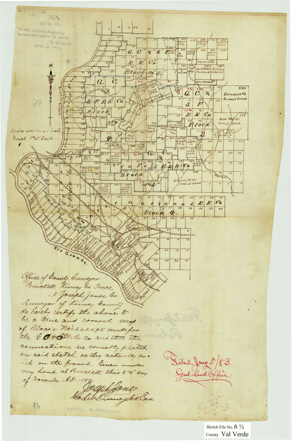
Val Verde County Sketch File 6 1/2
[Sketch of G. C. & S. F. R.R. Co. Blocks 1, 2, 3, 4, and 5 northwest from Del Rio]
-
Map/Doc
12563
-
Collection
General Map Collection
-
Object Dates
11/2/1882 (Creation Date)
1/5/1883 (File Date)
-
People and Organizations
Joseph Jones (Surveyor/Engineer)
-
Counties
Val Verde
-
Subjects
Surveying Sketch File
-
Height x Width
20.2 x 13.4 inches
51.3 x 34.0 cm
-
Medium
paper, manuscript
-
Features
Bullis' Creek
Devil's River
Lone Hill
San Pedro Creek
North Fork San Pedro Creek
East Fork San Pedro Creek
West Fork San Pedro Creek
Part of: General Map Collection
Edwards County Rolled Sketch JF

Print $20.00
- Digital $50.00
Edwards County Rolled Sketch JF
1915
Size 25.2 x 30.5 inches
Map/Doc 5819
Andrews County Rolled Sketch 31

Print $20.00
- Digital $50.00
Andrews County Rolled Sketch 31
Size 18.3 x 19.9 inches
Map/Doc 77175
Flight Mission No. CRC-3R, Frame 55, Chambers County

Print $20.00
- Digital $50.00
Flight Mission No. CRC-3R, Frame 55, Chambers County
1956
Size 18.6 x 22.4 inches
Map/Doc 84827
Anderson County

Print $20.00
- Digital $50.00
Anderson County
1871
Size 18.3 x 20.8 inches
Map/Doc 776
Gillespie County

Print $20.00
- Digital $50.00
Gillespie County
1918
Size 35.8 x 47.4 inches
Map/Doc 81950
Live Oak County Rolled Sketch 10

Print $20.00
- Digital $50.00
Live Oak County Rolled Sketch 10
1983
Size 38.4 x 43.9 inches
Map/Doc 9456
Dimmit County Sketch File 11a

Print $20.00
- Digital $50.00
Dimmit County Sketch File 11a
1880
Size 12.9 x 18.7 inches
Map/Doc 11339
Brazoria County Working Sketch 23

Print $20.00
- Digital $50.00
Brazoria County Working Sketch 23
1961
Size 37.9 x 32.4 inches
Map/Doc 67508
Brewster County Working Sketch 71b

Print $40.00
- Digital $50.00
Brewster County Working Sketch 71b
1961
Size 50.6 x 55.0 inches
Map/Doc 67870
Live Oak County Working Sketch 3

Print $20.00
- Digital $50.00
Live Oak County Working Sketch 3
1910
Size 21.5 x 19.0 inches
Map/Doc 70588
Flight Mission No. DAG-17K, Frame 77, Matagorda County

Print $20.00
- Digital $50.00
Flight Mission No. DAG-17K, Frame 77, Matagorda County
1952
Size 16.7 x 16.3 inches
Map/Doc 86336
Duval County Sketch File 50

Print $8.00
- Digital $50.00
Duval County Sketch File 50
Size 9.4 x 7.9 inches
Map/Doc 21412
You may also like
Andrews County Rolled Sketch 33

Print $40.00
- Digital $50.00
Andrews County Rolled Sketch 33
Size 131.2 x 22.0 inches
Map/Doc 9003
Montague County Boundary File 2b

Print $10.00
- Digital $50.00
Montague County Boundary File 2b
Size 9.0 x 11.1 inches
Map/Doc 57414
Correct map of the Chicago, Burlington and Quincy Rail Road and its principal connecting lines

Print $20.00
- Digital $50.00
Correct map of the Chicago, Burlington and Quincy Rail Road and its principal connecting lines
1881
Size 27.7 x 38.6 inches
Map/Doc 93956
Hamilton County Working Sketch 22

Print $20.00
- Digital $50.00
Hamilton County Working Sketch 22
1955
Size 41.6 x 19.0 inches
Map/Doc 63360
Trinity River, Hutchins Bridge Sheet

Print $20.00
- Digital $50.00
Trinity River, Hutchins Bridge Sheet
1922
Size 38.6 x 33.2 inches
Map/Doc 65190
Lubbock County

Print $20.00
- Digital $50.00
Lubbock County
1892
Size 20.1 x 19.3 inches
Map/Doc 3828
Map Showing Parallel 35°12' North Latitude from the 42nd Mile Post on the 100th Meridian to the Southeast Corner of Texas

Print $20.00
- Digital $50.00
Map Showing Parallel 35°12' North Latitude from the 42nd Mile Post on the 100th Meridian to the Southeast Corner of Texas
1890
Size 46.3 x 27.2 inches
Map/Doc 89839
Shackelford County Rolled Sketch 7

Print $20.00
- Digital $50.00
Shackelford County Rolled Sketch 7
2009
Size 36.9 x 24.8 inches
Map/Doc 89229
University of Texas System University Lands

Print $20.00
- Digital $50.00
University of Texas System University Lands
1929
Size 23.2 x 17.7 inches
Map/Doc 93246
Kimble County Sketch File 18

Print $22.00
- Digital $50.00
Kimble County Sketch File 18
1890
Size 8.8 x 14.2 inches
Map/Doc 28953
Mills County Boundary File 9

Print $40.00
- Digital $50.00
Mills County Boundary File 9
Size 13.7 x 8.6 inches
Map/Doc 57318
[Blocks S and M19 Resurvey]
![91440, [Blocks S and M19 Resurvey], Twichell Survey Records](https://historictexasmaps.com/wmedia_w700/maps/91440-1.tif.jpg)
Print $20.00
- Digital $50.00
[Blocks S and M19 Resurvey]
1903
Size 37.0 x 30.0 inches
Map/Doc 91440