Angelina County Sketch File 15a
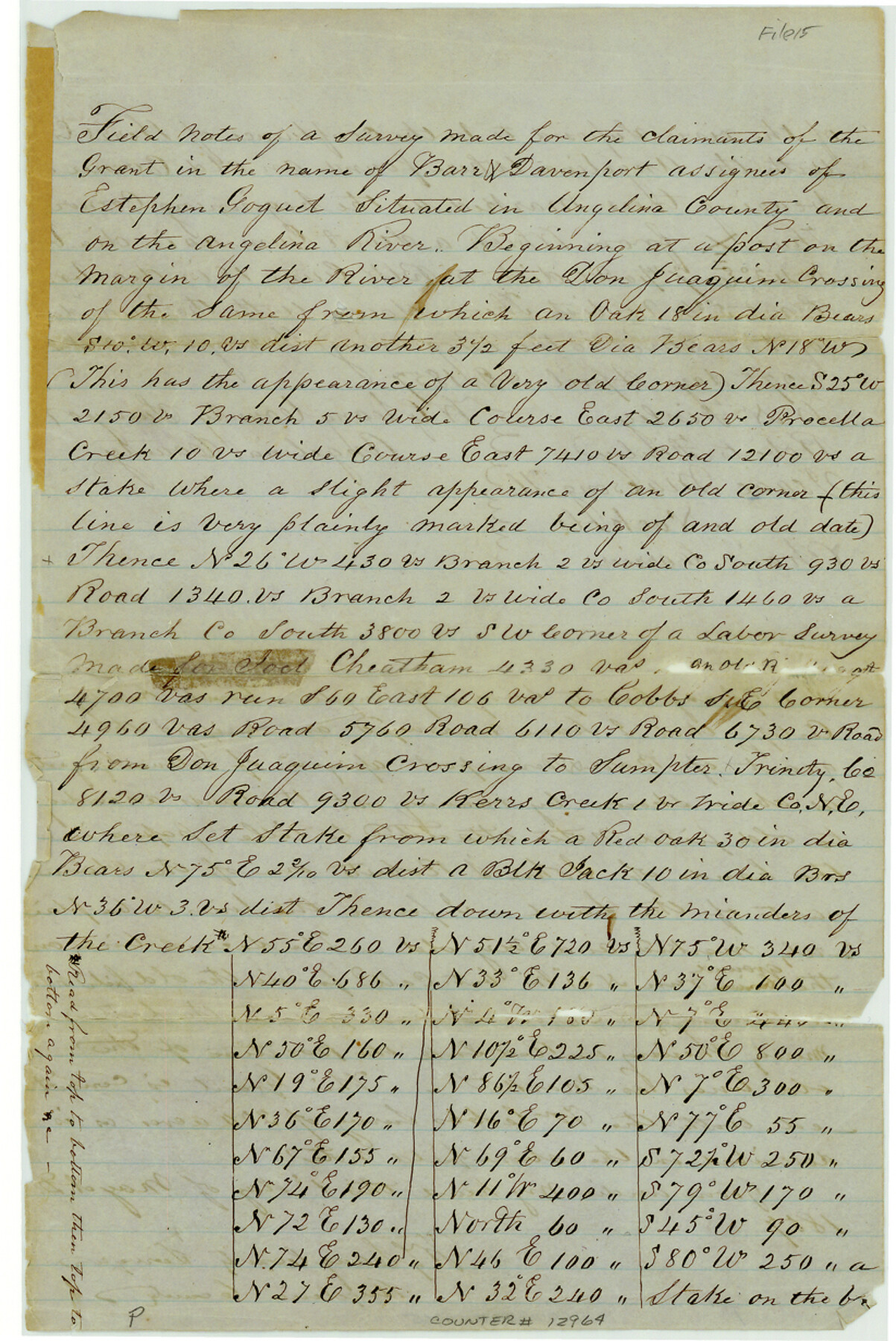
[Field notes and sketch made for claimants of the grant in the name of Barr and Davenport, assignee of Estephen Goguet on the Angelina River]
-
Map/Doc
12964
-
Collection
General Map Collection
-
Object Dates
1857/5/1 (Creation Date)
1857/5/19 (File Date)
-
People and Organizations
W.G. Lang (Surveyor/Engineer)
W.N. Finley (Chainman)
Roberts Finley (Chainman)
Isaac Massongill (Chainman)
Nockols (Chainman)
-
Counties
Angelina
-
Subjects
Surveying Sketch File
-
Height x Width
12.3 x 8.2 inches
31.2 x 20.8 cm
-
Medium
paper, manuscript
-
Features
Angelina River
Don Juaquin Crossing
Procella Creek
Sumpter
Kerr's Creek
Part of: General Map Collection
Hamilton County Sketch File 22

Print $2.00
- Digital $50.00
Hamilton County Sketch File 22
Size 6.8 x 5.5 inches
Map/Doc 24947

Karnes County Working Sketch 10

Print $20.00
- Digital $50.00
Karnes County Working Sketch 10
1970
Size 35.5 x 26.3 inches
Map/Doc 66658
Wichita County Working Sketch 25

Print $20.00
- Digital $50.00
Wichita County Working Sketch 25
1980
Size 27.1 x 27.7 inches
Map/Doc 72535
Intracoastal Waterway - Galveston Bay to West Bay including Galveston Bay Entrance

Print $20.00
- Digital $50.00
Intracoastal Waterway - Galveston Bay to West Bay including Galveston Bay Entrance
1962
Size 26.9 x 38.6 inches
Map/Doc 69936
Brazoria County Working Sketch 35

Print $40.00
- Digital $50.00
Brazoria County Working Sketch 35
1981
Size 43.5 x 66.2 inches
Map/Doc 67520
Bastrop County Boundary File 6

Print $40.00
- Digital $50.00
Bastrop County Boundary File 6
1923
Size 15.4 x 102.0 inches
Map/Doc 1691
Galveston County NRC Article 33.136 Sketch 50

Print $24.00
- Digital $50.00
Galveston County NRC Article 33.136 Sketch 50
2008
Size 24.0 x 36.3 inches
Map/Doc 88750
Map of Hunt Co.

Print $40.00
- Digital $50.00
Map of Hunt Co.
1894
Size 49.7 x 30.0 inches
Map/Doc 16855

Fannin County Working Sketch 7

Print $20.00
- Digital $50.00
Fannin County Working Sketch 7
1952
Size 25.4 x 28.5 inches
Map/Doc 69161
Clay County Working Sketch 7

Print $20.00
- Digital $50.00
Clay County Working Sketch 7
Size 17.5 x 14.7 inches
Map/Doc 68030
You may also like
Travis County Appraisal District Plat Map 2_2814

Print $20.00
- Digital $50.00
Travis County Appraisal District Plat Map 2_2814
Size 21.6 x 26.4 inches
Map/Doc 94218
Dickens County Sketch File G

Print $8.00
- Digital $50.00
Dickens County Sketch File G
Size 12.0 x 8.7 inches
Map/Doc 20854
El Paso County Rolled Sketch 52

Print $20.00
- Digital $50.00
El Paso County Rolled Sketch 52
1932
Size 18.3 x 24.3 inches
Map/Doc 5843
Sketch in Hockley County

Print $20.00
- Digital $50.00
Sketch in Hockley County
1911
Size 7.1 x 20.5 inches
Map/Doc 91123
Aransas County Sketch File 13

Print $4.00
- Digital $50.00
Aransas County Sketch File 13
Size 7.0 x 8.4 inches
Map/Doc 13126
Southern Pacific Lines Map of Texas

Print $20.00
- Digital $50.00
Southern Pacific Lines Map of Texas
1928
Size 27.4 x 22.4 inches
Map/Doc 95774
Upshur County Working Sketch 15, revised

Print $20.00
- Digital $50.00
Upshur County Working Sketch 15, revised
1996
Size 43.3 x 37.4 inches
Map/Doc 78217
[Neches River Bed, Plat and Calculations]
![2466, [Neches River Bed, Plat and Calculations], General Map Collection](https://historictexasmaps.com/wmedia_w700/maps/2466-GC.tif.jpg)
Print $40.00
- Digital $50.00
[Neches River Bed, Plat and Calculations]
1928
Size 27.3 x 51.0 inches
Map/Doc 2466
Terrell County Working Sketch 82

Print $20.00
- Digital $50.00
Terrell County Working Sketch 82
1991
Size 31.7 x 24.8 inches
Map/Doc 69603

Hartley County Sketch File 18

Print $4.00
- Digital $50.00
Hartley County Sketch File 18
2001
Size 11.1 x 8.7 inches
Map/Doc 76330
Plat Showing Theoretical Original City Limits of Corpus Christi

Print $20.00
- Digital $50.00
Plat Showing Theoretical Original City Limits of Corpus Christi
Size 41.3 x 41.7 inches
Map/Doc 4838