Bandera County Sketch File 27
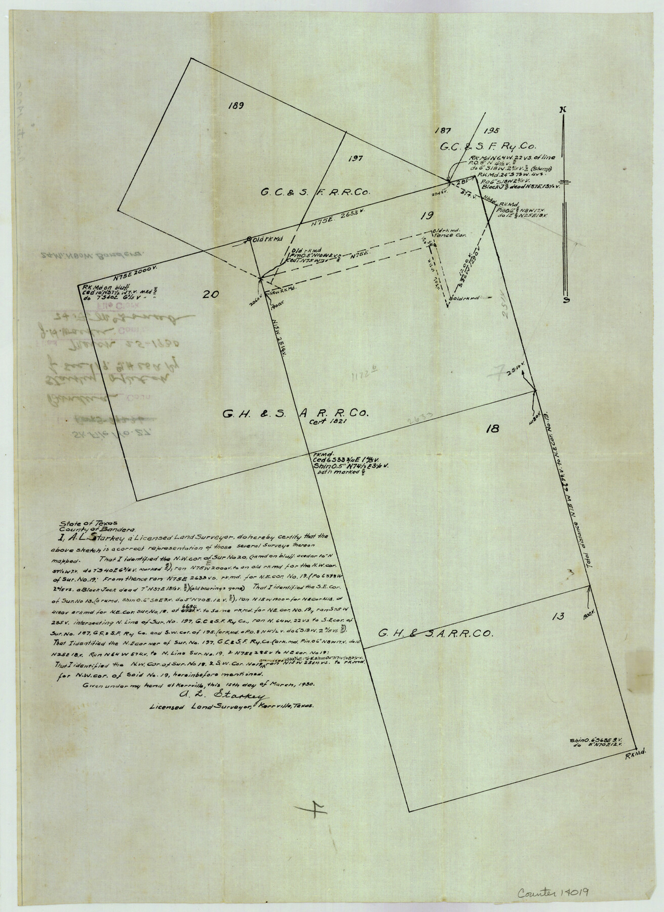
[Sketch of section 19, G. H. & S. A. R.R. Co. and surrounding surveys]
-
Map/Doc
14019
-
Collection
General Map Collection
-
Object Dates
1930/3/15 (Creation Date)
1930/3/25 (File Date)
-
People and Organizations
A.L. Starkey (Surveyor/Engineer)
-
Counties
Bandera
-
Subjects
Surveying Sketch File
-
Height x Width
17.1 x 12.4 inches
43.4 x 31.5 cm
-
Medium
linen, manuscript
Part of: General Map Collection
Fannin County Working Sketch 5

Print $20.00
- Digital $50.00
Fannin County Working Sketch 5
1939
Size 11.2 x 18.1 inches
Map/Doc 69159
Sterling County Working Sketch 10

Print $20.00
- Digital $50.00
Sterling County Working Sketch 10
1980
Size 39.6 x 26.3 inches
Map/Doc 63992
Wilbarger County Working Sketch 17

Print $20.00
- Digital $50.00
Wilbarger County Working Sketch 17
1957
Size 7.5 x 18.4 inches
Map/Doc 72555
Flight Mission No. CLL-1N, Frame 87, Willacy County

Print $20.00
- Digital $50.00
Flight Mission No. CLL-1N, Frame 87, Willacy County
1954
Size 18.3 x 22.0 inches
Map/Doc 87033
Nueces County NRC Article 33.136 Sketch 2

Print $20.00
- Digital $50.00
Nueces County NRC Article 33.136 Sketch 2
2002
Size 29.3 x 44.4 inches
Map/Doc 61622
McMullen County Sketch File 25

Print $6.00
- Digital $50.00
McMullen County Sketch File 25
1877
Size 8.5 x 14.2 inches
Map/Doc 31383
Flight Mission No. BRA-6M, Frame 73, Jefferson County

Print $20.00
- Digital $50.00
Flight Mission No. BRA-6M, Frame 73, Jefferson County
1953
Size 18.6 x 22.3 inches
Map/Doc 85417
Gonzales County

Print $40.00
- Digital $50.00
Gonzales County
1920
Size 48.4 x 44.2 inches
Map/Doc 4706
Angelina County Sketch File 15h

Print $4.00
- Digital $50.00
Angelina County Sketch File 15h
1889
Size 10.0 x 8.0 inches
Map/Doc 12998
Ellis County Sketch File 21

Print $24.00
- Digital $50.00
Ellis County Sketch File 21
1879
Size 7.6 x 12.4 inches
Map/Doc 21878
Nacogdoches County Working Sketch 6

Print $20.00
- Digital $50.00
Nacogdoches County Working Sketch 6
1955
Size 14.7 x 12.5 inches
Map/Doc 71222
Webb County Rolled Sketch 78A

Print $20.00
- Digital $50.00
Webb County Rolled Sketch 78A
Size 28.4 x 23.0 inches
Map/Doc 90053
You may also like
Texas, an Agricultural Empire

Texas, an Agricultural Empire
1915
Size 10.8 x 8.0 inches
Map/Doc 96593
Bell County Rolled Sketch 1

Print $20.00
- Digital $50.00
Bell County Rolled Sketch 1
1954
Size 38.1 x 41.1 inches
Map/Doc 75938
Sutton County Rolled Sketch 42

Print $20.00
- Digital $50.00
Sutton County Rolled Sketch 42
Size 16.2 x 20.1 inches
Map/Doc 7884
Potter County Rolled Sketch 3

Print $20.00
- Digital $50.00
Potter County Rolled Sketch 3
1892
Map/Doc 9758
Marion County Working Sketch 12a

Print $20.00
- Digital $50.00
Marion County Working Sketch 12a
1953
Size 23.9 x 33.2 inches
Map/Doc 70788
Baylor County Working Sketch 7

Print $20.00
- Digital $50.00
Baylor County Working Sketch 7
1950
Size 31.4 x 24.0 inches
Map/Doc 67292
Hemphill County

Print $20.00
- Digital $50.00
Hemphill County
1932
Size 39.9 x 36.6 inches
Map/Doc 73177
Map of the United States to accompany Granger's Southern and Western Texas Guide

Print $20.00
Map of the United States to accompany Granger's Southern and Western Texas Guide
1878
Size 26.4 x 20.4 inches
Map/Doc 76236
Calhoun County Rolled Sketch 12

Print $40.00
- Digital $50.00
Calhoun County Rolled Sketch 12
1940
Size 30.2 x 54.8 inches
Map/Doc 43619
Presidio County Sketch File 118

Print $16.00
- Digital $50.00
Presidio County Sketch File 118
Size 14.3 x 8.9 inches
Map/Doc 34919
Hardeman County Working Sketch 10

Print $20.00
- Digital $50.00
Hardeman County Working Sketch 10
1960
Size 21.9 x 29.9 inches
Map/Doc 63391
Calhoun County NRC Article 33.136 Sketch 5

Print $34.00
- Digital $50.00
Calhoun County NRC Article 33.136 Sketch 5
2012
Size 24.0 x 36.0 inches
Map/Doc 94633