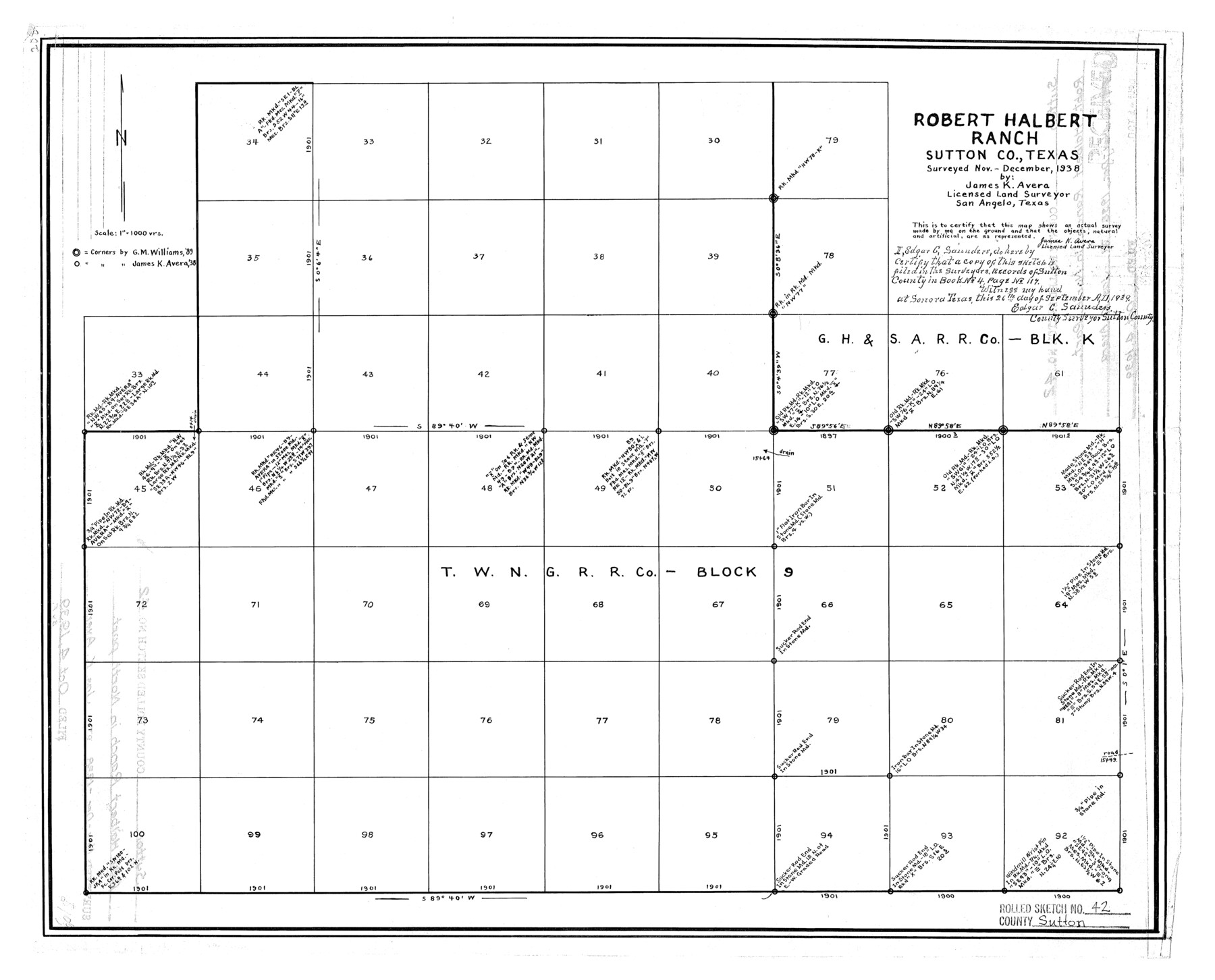
Sutton County Rolled Sketch 42
Robert Halbert Ranch, Sutton Co., Texas
-
Map/Doc
7884
-
Collection
General Map Collection
-
Object Dates
10/4/1939 (File Date)
12/1938 (Survey Date)
-
People and Organizations
James K. Avera (Surveyor/Engineer)
-
Counties
Sutton
-
Subjects
Surveying Rolled Sketch
-
Height x Width
16.2 x 20.1 inches
41.2 x 51.1 cm
-
Scale
1" = 1000 varas
Part of: General Map Collection
Flight Mission No. BRA-8M, Frame 113, Jefferson County

Print $20.00
- Digital $50.00
Flight Mission No. BRA-8M, Frame 113, Jefferson County
1953
Size 18.6 x 22.3 inches
Map/Doc 85609
Dickens County Rolled Sketch P3

Print $20.00
- Digital $50.00
Dickens County Rolled Sketch P3
1917
Size 41.4 x 36.1 inches
Map/Doc 8785
Flight Mission No. DCL-6C, Frame 49, Kenedy County

Print $20.00
- Digital $50.00
Flight Mission No. DCL-6C, Frame 49, Kenedy County
1943
Size 18.6 x 22.5 inches
Map/Doc 85891
Hudspeth County Sketch File 43

Print $10.00
- Digital $50.00
Hudspeth County Sketch File 43
1982
Size 14.3 x 8.9 inches
Map/Doc 27022
Liberty County Working Sketch 13

Print $20.00
- Digital $50.00
Liberty County Working Sketch 13
1915
Size 18.8 x 15.5 inches
Map/Doc 70472
Houston & Great Northern RR through Smith & other counties

Print $66.00
- Digital $50.00
Houston & Great Northern RR through Smith & other counties
1872
Size 14.2 x 8.4 inches
Map/Doc 64339
Flight Mission No. DAG-23K, Frame 179, Matagorda County

Print $20.00
- Digital $50.00
Flight Mission No. DAG-23K, Frame 179, Matagorda County
1953
Size 18.5 x 22.4 inches
Map/Doc 86514
Hudspeth County Working Sketch 52

Print $20.00
- Digital $50.00
Hudspeth County Working Sketch 52
1985
Size 29.8 x 36.6 inches
Map/Doc 66337
Clay County Working Sketch 3

Print $20.00
- Digital $50.00
Clay County Working Sketch 3
1923
Size 19.7 x 9.3 inches
Map/Doc 68026
Stonewall County Sketch File B2

Print $20.00
- Digital $50.00
Stonewall County Sketch File B2
1902
Size 25.8 x 25.0 inches
Map/Doc 12377
Throckmorton County Working Sketch 12

Print $20.00
- Digital $50.00
Throckmorton County Working Sketch 12
2019
Size 24.7 x 36.7 inches
Map/Doc 95719
Newton County Working Sketch 42

Print $20.00
- Digital $50.00
Newton County Working Sketch 42
1981
Size 26.4 x 22.5 inches
Map/Doc 71288
You may also like
Map of C. C. Slaughter Cattle Co.'s Ranch, Cochran-Hockley Counties, Texas

Print $20.00
- Digital $50.00
Map of C. C. Slaughter Cattle Co.'s Ranch, Cochran-Hockley Counties, Texas
Size 27.4 x 20.3 inches
Map/Doc 90439
Real County Working Sketch 68

Print $20.00
- Digital $50.00
Real County Working Sketch 68
1973
Size 21.9 x 24.4 inches
Map/Doc 71960
Zavala County Sketch File 19

Print $6.00
- Digital $50.00
Zavala County Sketch File 19
1909
Size 5.6 x 8.8 inches
Map/Doc 41371
Flight Mission No. CRC-4R, Frame 65, Chambers County

Print $20.00
- Digital $50.00
Flight Mission No. CRC-4R, Frame 65, Chambers County
1956
Size 18.6 x 22.4 inches
Map/Doc 84869
Lavaca County Sketch File 2

Print $6.00
- Digital $50.00
Lavaca County Sketch File 2
1849
Size 8.7 x 7.5 inches
Map/Doc 29630
Hidalgo County Rolled Sketch 13

Print $20.00
- Digital $50.00
Hidalgo County Rolled Sketch 13
1960
Size 19.0 x 31.4 inches
Map/Doc 6212
Map of Anderson County

Print $20.00
- Digital $50.00
Map of Anderson County
1895
Size 46.7 x 37.5 inches
Map/Doc 4866
Flight Mission No. DQN-2K, Frame 6, Calhoun County

Print $20.00
- Digital $50.00
Flight Mission No. DQN-2K, Frame 6, Calhoun County
1953
Size 18.4 x 22.2 inches
Map/Doc 84223
Wharton County Sketch File 4a

Print $4.00
- Digital $50.00
Wharton County Sketch File 4a
1876
Size 12.7 x 8.1 inches
Map/Doc 39919
Wharton County Sketch File 15

Print $20.00
- Digital $50.00
Wharton County Sketch File 15
Size 18.2 x 21.1 inches
Map/Doc 12665
Kaufman County State Real Property Sketch 2

Print $20.00
- Digital $50.00
Kaufman County State Real Property Sketch 2
2007
Size 24.2 x 35.4 inches
Map/Doc 88672
Matagorda Bay and Peninsula from Matagorda Oyster Lake

Print $40.00
- Digital $50.00
Matagorda Bay and Peninsula from Matagorda Oyster Lake
1915
Size 33.1 x 62.0 inches
Map/Doc 69981