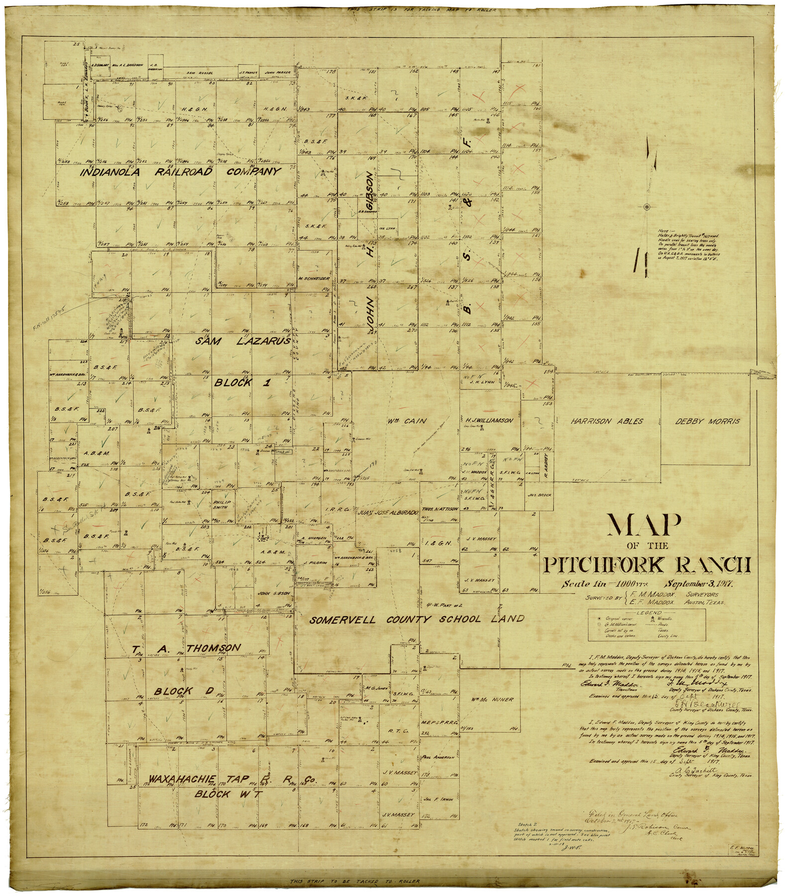
Dickens County Rolled Sketch P3
Map of the Pitchfork Ranch
-
Map/Doc
8785
-
Collection
General Map Collection
-
Object Dates
9/3/1917 (Creation Date)
10/2/1917 (File Date)
-
People and Organizations
Edward F. Maddox (Draftsman)
F.M. Maddox (Surveyor/Engineer)
Edward F. Maddox (Surveyor/Engineer)
-
Counties
Dickens King
-
Subjects
Surveying Rolled Sketch
-
Height x Width
41.4 x 36.1 inches
105.2 x 91.7 cm
-
Medium
van dyke/brownline/sepia
-
Scale
1" = 1000 varas
Part of: General Map Collection
Flight Mission No. CUI-1H, Frame 169, Milam County

Print $20.00
- Digital $50.00
Flight Mission No. CUI-1H, Frame 169, Milam County
1951
Size 18.7 x 22.6 inches
Map/Doc 86611
Comanche County Sketch File 22b

Print $40.00
- Digital $50.00
Comanche County Sketch File 22b
1872
Size 12.1 x 14.8 inches
Map/Doc 19109
Carson County Working Sketch 3

Print $20.00
- Digital $50.00
Carson County Working Sketch 3
1922
Size 18.3 x 26.3 inches
Map/Doc 67874
Hidalgo County Sketch File 7

Print $20.00
- Digital $50.00
Hidalgo County Sketch File 7
1882
Size 20.3 x 28.2 inches
Map/Doc 11761
Travis County Sketch File 15

Print $4.00
- Digital $50.00
Travis County Sketch File 15
Size 12.8 x 8.1 inches
Map/Doc 38310
Hunt County Boundary File 10a

Print $40.00
- Digital $50.00
Hunt County Boundary File 10a
Size 42.1 x 10.5 inches
Map/Doc 55262
Lipscomb County Boundary File 12

Print $4.00
- Digital $50.00
Lipscomb County Boundary File 12
Size 10.6 x 8.1 inches
Map/Doc 56351
Galveston County NRC Article 33.136 Sketch 81

Print $202.00
- Digital $50.00
Galveston County NRC Article 33.136 Sketch 81
2015
Size 34.0 x 22.0 inches
Map/Doc 94976
Young County Sketch File 4

Print $6.00
- Digital $50.00
Young County Sketch File 4
1852
Size 5.3 x 4.3 inches
Map/Doc 40849
Threading the Islands: Which track fits?

Threading the Islands: Which track fits?
1986
Size 20.5 x 14.7 inches
Map/Doc 96838
Shores of Laguna Madre, Texas from Triangulation Station Griffins to Triangulation Station Camp No. 2

Print $40.00
- Digital $50.00
Shores of Laguna Madre, Texas from Triangulation Station Griffins to Triangulation Station Camp No. 2
1882
Size 33.2 x 54.3 inches
Map/Doc 73483
Bell County Rolled Sketch 1

Print $20.00
- Digital $50.00
Bell County Rolled Sketch 1
1954
Size 39.7 x 43.2 inches
Map/Doc 8445
You may also like
Flight Mission No. BRE-2P, Frame 130, Nueces County

Print $20.00
- Digital $50.00
Flight Mission No. BRE-2P, Frame 130, Nueces County
1956
Size 18.6 x 22.3 inches
Map/Doc 86803
Red River County Working Sketch 81-2

Print $20.00
- Digital $50.00
Red River County Working Sketch 81-2
1987
Size 14.6 x 18.6 inches
Map/Doc 72065
Blanco County Sketch File 18

Print $4.00
- Digital $50.00
Blanco County Sketch File 18
1877
Size 12.6 x 8.5 inches
Map/Doc 14594
San Augustine County Sketch File 6

Print $4.00
San Augustine County Sketch File 6
1858
Size 6.4 x 7.7 inches
Map/Doc 35644
The Republic County of Robertson. January 29, 1842

Print $20.00
The Republic County of Robertson. January 29, 1842
2020
Size 16.9 x 21.7 inches
Map/Doc 96262
Sectional Map of the Eastern Half of Texas traversed by the Missouri, Kansas & Texas Railway, showing the crops adapted to each section, with the elevation and average annual rainfall

Print $20.00
- Digital $50.00
Sectional Map of the Eastern Half of Texas traversed by the Missouri, Kansas & Texas Railway, showing the crops adapted to each section, with the elevation and average annual rainfall
Size 18.3 x 14.7 inches
Map/Doc 96602
Bexar County Rolled Sketch 4

Print $20.00
- Digital $50.00
Bexar County Rolled Sketch 4
Size 24.3 x 36.8 inches
Map/Doc 5137
FT. W. & R. G. Ry. Right of Way Map, Winchell to Brady, McCulloch County, Texas

Print $40.00
- Digital $50.00
FT. W. & R. G. Ry. Right of Way Map, Winchell to Brady, McCulloch County, Texas
1918
Size 38.0 x 121.9 inches
Map/Doc 61410

Crane County Working Sketch 6

Print $40.00
- Digital $50.00
Crane County Working Sketch 6
1928
Size 92.2 x 25.3 inches
Map/Doc 68283
Castro County Sketch File 4b

Print $4.00
- Digital $50.00
Castro County Sketch File 4b
Size 13.5 x 8.9 inches
Map/Doc 17467
Map of the State of Coahuila and Texas

Print $20.00
Map of the State of Coahuila and Texas
1833
Size 16.1 x 20.2 inches
Map/Doc 76246