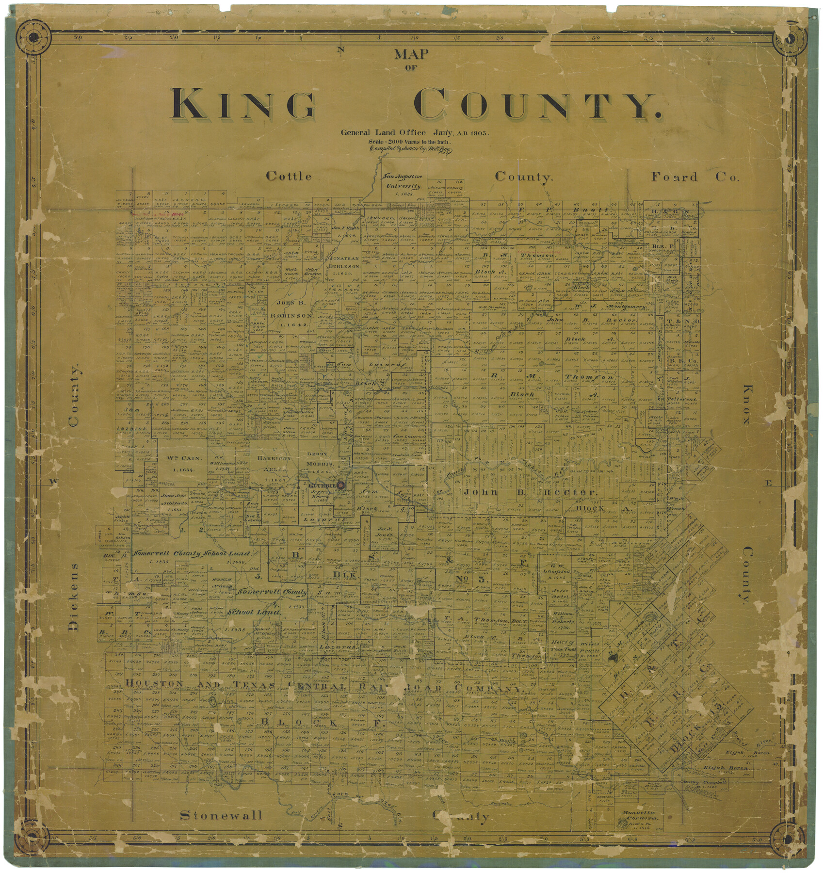
Map of King County
-
Map/Doc
16867
-
Collection
General Map Collection
-
Object Dates
1/1903 (Creation Date)
-
People and Organizations
J. Watt Legg (Draftsman)
-
Counties
King
-
Subjects
County
-
Height x Width
44.8 x 42.4 inches
113.8 x 107.7 cm
-
Features
McKenzie Trail
Guthrie Road
Saline Fork
Kiowa Peak
Benjamin Wagon Road
Brush Knob
Croton Creek
Guthrie and Benjamin Wagon Road
Dikes Creek
Newman Creek
Spring On Saline Fork
Quintilla Peaks
"Pa" Creek
Saline Creek
Tongue Mound
Brazos River
Guthrie
Ash Creek
Salt Fork of Wichita River
Road [from Salt Flats]
Old Mail Camp
Salt Croton [Creek]
Bob Creek
Weadington Creek
Mount Louisa
Mount Louisa
Pen Branch [of North Croton Creek]
Dove Creek
Panther Cañon
South Fork of Wichita River
North Croton River
Salt Fork of Brazos River
Gyp Creek
Flat Top Mountain
Jay Tank
Buzzard Peak
Little Croton Creek
Hackberry Creek
Paducah Road
Bitter Creek
Round Peak
Hay Rick Mountain
Middle Fork of Wichita River
Mason's Tank
Gibson's Tank
Road [from Gibson's Tank]
Fielder Branch of Middle Fork of Wichita River
Cottonwood Creek
Old Mail Camp
Farrer's Creek
Wagon Road
Pouring Spring
Military Road
Baby Creek
Tang Creek
Pole Cat Creek
Buford's Creek
Road [through Rocky Falls]
Spring Branch
Natural Bridge
Dutchman's Branch
Old McKenzie Trail
Dickens Road
Matador Road
Tank Creek
Rocky Falls
North Wichita Creek
Terrace Mountain
Rocky Falls
Willow Creek
Round Mountain
Bird's Creek
Ox Yoke Creek
Mail Creek
Spring Creek
Part of: General Map Collection
Triangulation Net of the United States

Print $20.00
- Digital $50.00
Triangulation Net of the United States
1938
Size 28.1 x 42.2 inches
Map/Doc 3117
Coke County Rolled Sketch 6

Print $20.00
- Digital $50.00
Coke County Rolled Sketch 6
Size 31.1 x 32.2 inches
Map/Doc 8625
Live Oak County Sketch File 13

Print $17.00
- Digital $50.00
Live Oak County Sketch File 13
1880
Size 10.2 x 13.7 inches
Map/Doc 30270
Sutton County Working Sketch 44

Print $20.00
- Digital $50.00
Sutton County Working Sketch 44
1951
Size 29.8 x 27.5 inches
Map/Doc 62387
Hamilton County Sketch File 14

Print $10.00
- Digital $50.00
Hamilton County Sketch File 14
Size 10.1 x 8.0 inches
Map/Doc 24937
Upton County Working Sketch 21

Print $20.00
- Digital $50.00
Upton County Working Sketch 21
1950
Size 33.8 x 36.0 inches
Map/Doc 69517
Wharton County Working Sketch 3

Print $20.00
- Digital $50.00
Wharton County Working Sketch 3
Size 17.5 x 16.4 inches
Map/Doc 72467
Wise County Working Sketch 2

Print $20.00
- Digital $50.00
Wise County Working Sketch 2
1940
Size 30.1 x 41.9 inches
Map/Doc 72616
Coryell County Rolled Sketch 3

Print $20.00
- Digital $50.00
Coryell County Rolled Sketch 3
1974
Size 24.6 x 36.4 inches
Map/Doc 5567

Brazos Island Harbor, Texas - Dredging Entrance Channel Plan

Print $20.00
- Digital $50.00
Brazos Island Harbor, Texas - Dredging Entrance Channel Plan
1990
Size 14.5 x 20.1 inches
Map/Doc 83338
Travis County Sketch File 32A

Print $6.00
- Digital $50.00
Travis County Sketch File 32A
1893
Size 12.5 x 10.9 inches
Map/Doc 38347
You may also like
Flight Mission No. DQN-6K, Frame 7, Calhoun County

Print $20.00
- Digital $50.00
Flight Mission No. DQN-6K, Frame 7, Calhoun County
1953
Size 18.4 x 22.1 inches
Map/Doc 84429
El Paso County Rolled Sketch 50

Print $40.00
- Digital $50.00
El Paso County Rolled Sketch 50
Size 19.7 x 76.0 inches
Map/Doc 76430
Flight Mission No. CRC-4R, Frame 182, Chambers County

Print $20.00
- Digital $50.00
Flight Mission No. CRC-4R, Frame 182, Chambers County
1956
Size 18.5 x 22.1 inches
Map/Doc 84933

Culberson County Sketch File 45

Print $6.00
- Digital $50.00
Culberson County Sketch File 45
2002
Size 14.2 x 8.8 inches
Map/Doc 76367
Jeff Davis County Working Sketch 18

Print $20.00
- Digital $50.00
Jeff Davis County Working Sketch 18
1956
Size 31.3 x 21.5 inches
Map/Doc 66513
Runnels County Rolled Sketch 44

Print $40.00
- Digital $50.00
Runnels County Rolled Sketch 44
Size 43.0 x 53.9 inches
Map/Doc 9871
Tabula Terre Nove

Print $20.00
- Digital $50.00
Tabula Terre Nove
1513
Size 18.7 x 24.6 inches
Map/Doc 93800
Map of Nacogdoches County

Print $20.00
- Digital $50.00
Map of Nacogdoches County
1846
Size 44.7 x 40.0 inches
Map/Doc 87355
Angelina County Working Sketch 18

Print $20.00
- Digital $50.00
Angelina County Working Sketch 18
1944
Size 26.6 x 28.8 inches
Map/Doc 67099
[Map of Located Land of Gulf, Colorado & Santa Fe Ry. Co. through Denton]
![64340, [Map of Located Land of Gulf, Colorado & Santa Fe Ry. Co. through Denton], General Map Collection](https://historictexasmaps.com/wmedia_w700/maps/64340.tif.jpg)
Print $40.00
- Digital $50.00
[Map of Located Land of Gulf, Colorado & Santa Fe Ry. Co. through Denton]
Size 122.8 x 28.3 inches
Map/Doc 64340
Terrell County Working Sketch 78

Print $20.00
- Digital $50.00
Terrell County Working Sketch 78
1983
Size 41.0 x 37.2 inches
Map/Doc 69599