Cottle County Sketch File 15
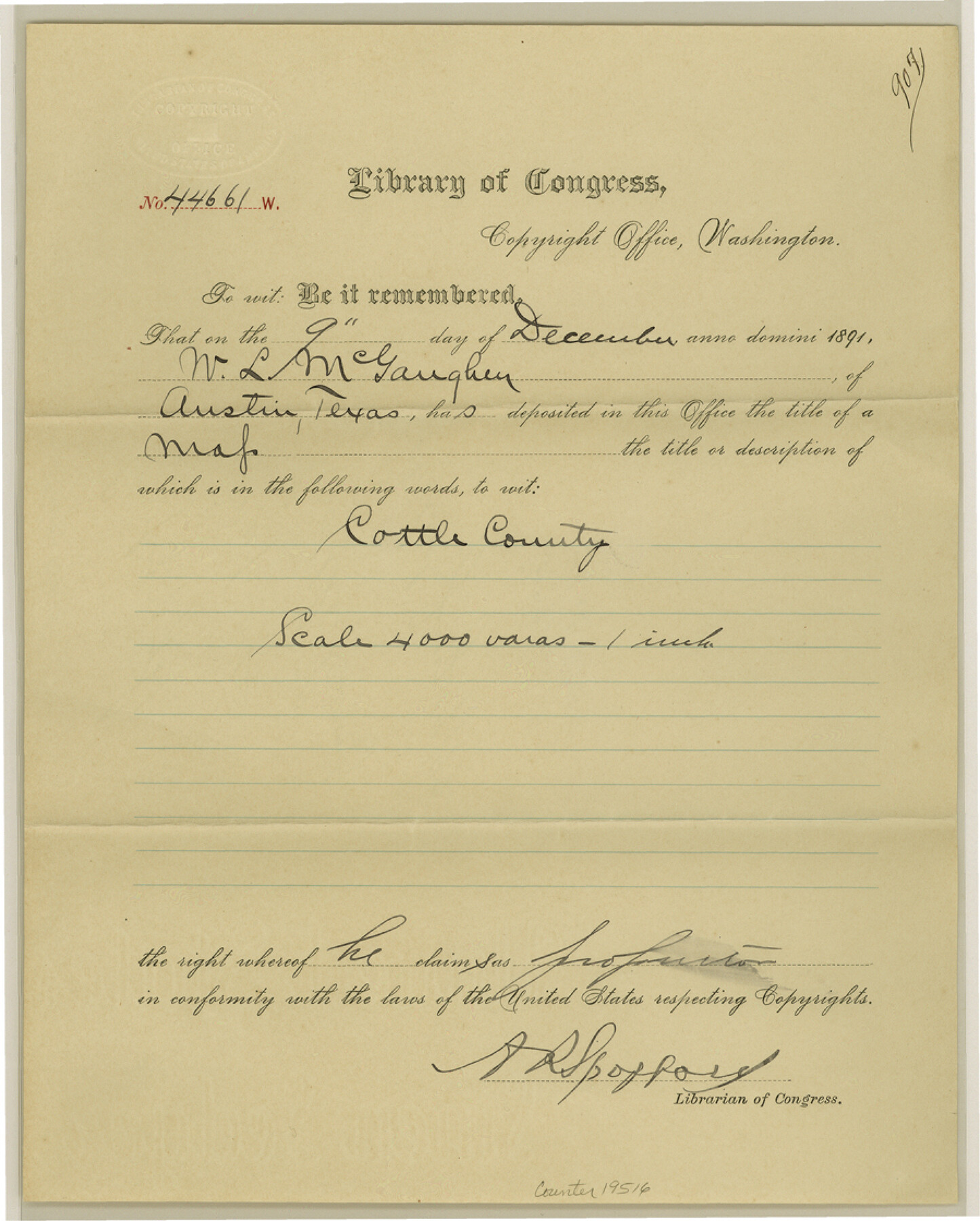
[Certificate of copyright from Library of Congress for Cottle County Map]
-
Map/Doc
19516
-
Collection
General Map Collection
-
Object Dates
1891/12/9 (Creation Date)
1892/1/19 (File Date)
-
People and Organizations
Wm. Bramlette (GLO Clerk)
-
Counties
Cottle
-
Subjects
Surveying Sketch File
-
Height x Width
11.2 x 9.0 inches
28.4 x 22.9 cm
-
Medium
paper, manuscript
-
Scale
1:4000
Part of: General Map Collection
Real County Working Sketch 25

Print $20.00
- Digital $50.00
Real County Working Sketch 25
1946
Size 26.5 x 24.7 inches
Map/Doc 71917
Cooke County Boundary File 1a

Print $32.00
- Digital $50.00
Cooke County Boundary File 1a
Size 12.6 x 7.5 inches
Map/Doc 51828
Hemphill County Working Sketch 8

Print $40.00
- Digital $50.00
Hemphill County Working Sketch 8
1965
Size 25.8 x 64.6 inches
Map/Doc 66103
Edwards County Sketch File 32 1/2

Print $6.00
- Digital $50.00
Edwards County Sketch File 32 1/2
Size 11.4 x 17.4 inches
Map/Doc 21767
Rio Grande, Run Sheet

Print $2.00
- Digital $50.00
Rio Grande, Run Sheet
1931
Size 17.0 x 14.3 inches
Map/Doc 65120
Red River, Kelsey Sheet, Upshur County

Print $4.00
- Digital $50.00
Red River, Kelsey Sheet, Upshur County
1933
Size 21.1 x 24.2 inches
Map/Doc 65056
Flight Mission No. CLL-1N, Frame 17, Willacy County

Print $20.00
- Digital $50.00
Flight Mission No. CLL-1N, Frame 17, Willacy County
1954
Size 18.5 x 22.1 inches
Map/Doc 87004
Milam County Sketch File 9

Print $4.00
- Digital $50.00
Milam County Sketch File 9
1873
Size 12.8 x 8.2 inches
Map/Doc 31639
Dimmit County Rolled Sketch 15

Print $20.00
- Digital $50.00
Dimmit County Rolled Sketch 15
1925
Size 32.8 x 23.4 inches
Map/Doc 5723
Concho County

Print $40.00
- Digital $50.00
Concho County
1947
Size 48.1 x 37.3 inches
Map/Doc 95464
Ward County Sketch File 11

Print $20.00
- Digital $50.00
Ward County Sketch File 11
1943
Size 17.4 x 20.4 inches
Map/Doc 12600
Flight Mission No. CLL-1N, Frame 13, Willacy County

Print $20.00
- Digital $50.00
Flight Mission No. CLL-1N, Frame 13, Willacy County
1954
Size 18.3 x 22.0 inches
Map/Doc 87000
You may also like
McCulloch County Working Sketch 3

Print $20.00
- Digital $50.00
McCulloch County Working Sketch 3
1951
Size 30.9 x 36.8 inches
Map/Doc 70678
Presidio County Working Sketch 89

Print $20.00
- Digital $50.00
Presidio County Working Sketch 89
1972
Size 28.8 x 37.5 inches
Map/Doc 71766
Galveston County NRC Article 33.136 Sketch 15

Print $24.00
- Digital $50.00
Galveston County NRC Article 33.136 Sketch 15
2002
Size 23.0 x 35.0 inches
Map/Doc 77046
Index for Texas Railroad ROW & track maps available on microfilm at THD & Archives and Records

Print $2.00
- Digital $50.00
Index for Texas Railroad ROW & track maps available on microfilm at THD & Archives and Records
1977
Size 11.2 x 8.6 inches
Map/Doc 60759
Clay County Boundary File 16

Print $56.00
- Digital $50.00
Clay County Boundary File 16
Size 9.1 x 3.7 inches
Map/Doc 51422
Andrews County Working Sketch 4

Print $20.00
- Digital $50.00
Andrews County Working Sketch 4
1954
Size 42.8 x 19.2 inches
Map/Doc 67050
Travis County Sketch File 71

Print $10.00
- Digital $50.00
Travis County Sketch File 71
1840
Size 12.9 x 8.3 inches
Map/Doc 38456
Flight Mission No. BRA-7M, Frame 133, Jefferson County

Print $20.00
- Digital $50.00
Flight Mission No. BRA-7M, Frame 133, Jefferson County
1953
Size 18.6 x 22.3 inches
Map/Doc 85527
Comanche County Rolled Sketch 3

Print $20.00
- Digital $50.00
Comanche County Rolled Sketch 3
2017
Size 35.1 x 44.9 inches
Map/Doc 95384

Galveston County Rolled Sketch 8

Print $20.00
- Digital $50.00
Galveston County Rolled Sketch 8
Size 24.3 x 34.8 inches
Map/Doc 5951
Liberty County Rolled Sketch N

Print $20.00
- Digital $50.00
Liberty County Rolled Sketch N
Size 44.7 x 38.5 inches
Map/Doc 10180