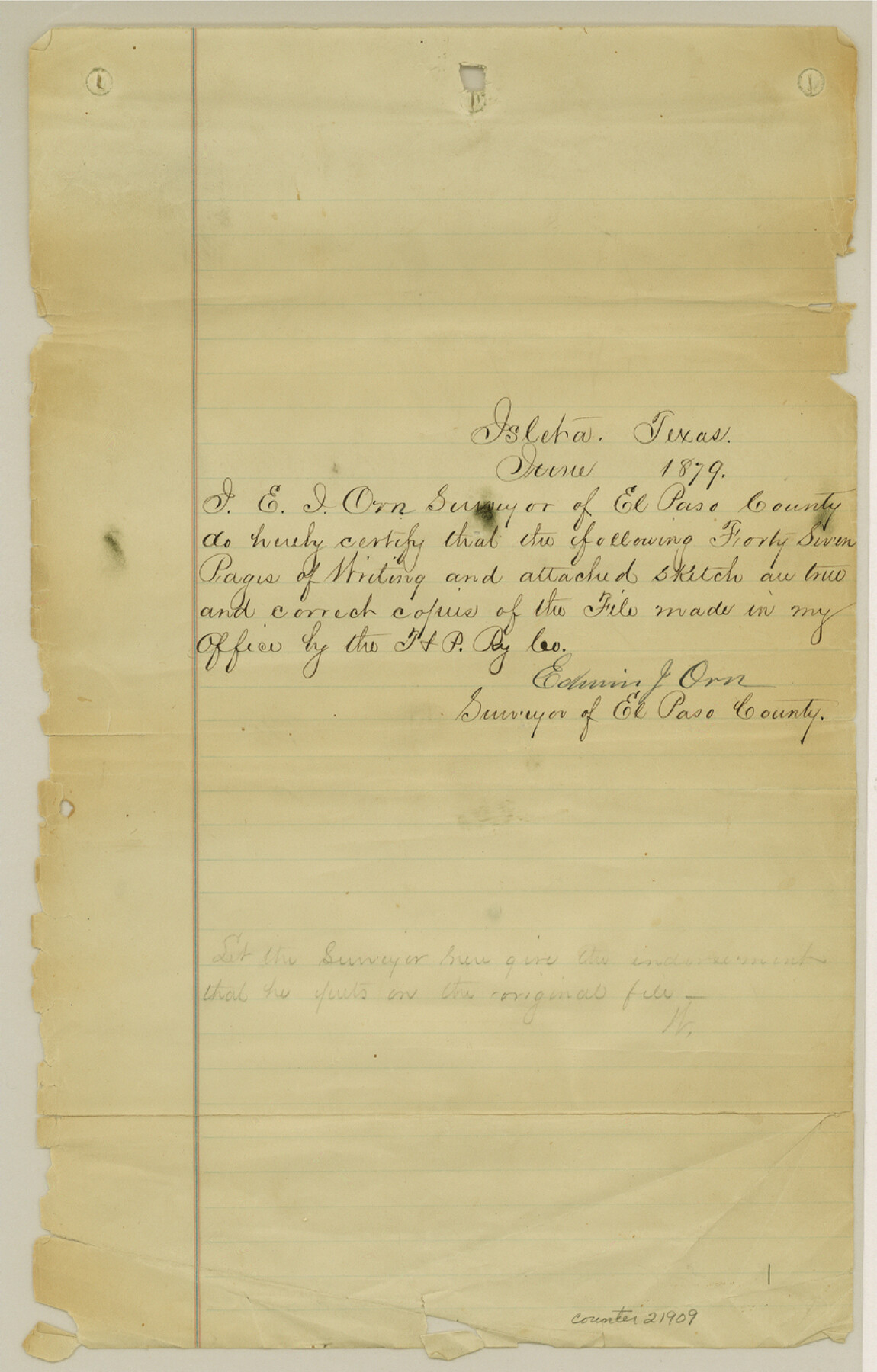
El Paso County Sketch File 3
[Report on T. & P. RR. Co. certificates 5584 to 7027 - 1444 certificates of 640 acres each]
-
Map/Doc
21909
-
Collection
General Map Collection
-
Object Dates
1879/6/4 (Creation Date)
-
People and Organizations
Edwin J. Orn (Surveyor/Engineer)
-
Counties
El Paso Presidio
-
Subjects
Surveying Sketch File
-
Height x Width
13.0 x 8.3 inches
33.0 x 21.1 cm
-
Medium
paper, manuscript
-
Features
Isleta [sic]
Santa Cruz
Organ Mountains
Tulerosa Valley
Tomales Creek
Arroyo de los Tomales
Intevosa Valley
Franklin
Hueco Mountains
Rio Grande
Mesa Sija
Delaware Creek
Fort Quitman
El Paso Road
Salt Lake Valley
Eagle Mountains
Carrizo Mountains
Diabola [sic] Mountains
Willow Creek
San Martin's Springs
Cayote [sic] Creek
Guadalupe Peak
Part of: General Map Collection
Harris County Historic Topographic 31

Print $20.00
- Digital $50.00
Harris County Historic Topographic 31
1915
Size 29.2 x 22.7 inches
Map/Doc 65842
Galveston County Sketch File 5

Print $4.00
- Digital $50.00
Galveston County Sketch File 5
1848
Size 8.6 x 9.0 inches
Map/Doc 23358
Flight Mission No. DIX-6P, Frame 188, Aransas County

Print $20.00
- Digital $50.00
Flight Mission No. DIX-6P, Frame 188, Aransas County
1956
Size 19.0 x 22.9 inches
Map/Doc 83850
Flight Mission No. CRK-3P, Frame 131, Refugio County

Print $20.00
- Digital $50.00
Flight Mission No. CRK-3P, Frame 131, Refugio County
1956
Size 18.5 x 22.4 inches
Map/Doc 86919
[Liberty County, Texas]
![2058, [Liberty County, Texas], General Map Collection](https://historictexasmaps.com/wmedia_w700/maps/2058-1.tif.jpg)
Print $20.00
- Digital $50.00
[Liberty County, Texas]
1890
Size 23.7 x 18.3 inches
Map/Doc 2058
Rains County Working Sketch 2

Print $20.00
- Digital $50.00
Rains County Working Sketch 2
Size 14.0 x 12.2 inches
Map/Doc 71828
Leon County Rolled Sketch 17

Print $20.00
- Digital $50.00
Leon County Rolled Sketch 17
1981
Size 25.2 x 33.4 inches
Map/Doc 6602
Current Miscellaneous File 69

Print $10.00
- Digital $50.00
Current Miscellaneous File 69
1916
Size 11.2 x 8.8 inches
Map/Doc 74145
Robertson County Sketch File 6

Print $4.00
Robertson County Sketch File 6
1870
Size 8.9 x 7.6 inches
Map/Doc 35362
Morris County Rolled Sketch 2A

Print $20.00
- Digital $50.00
Morris County Rolled Sketch 2A
Size 24.3 x 19.2 inches
Map/Doc 10284
Flight Mission No. BRA-9M, Frame 68, Jefferson County

Print $20.00
- Digital $50.00
Flight Mission No. BRA-9M, Frame 68, Jefferson County
1953
Size 18.7 x 22.5 inches
Map/Doc 85651
[F. W. & D. C. Ry. Co. Alignment and Right of Way Map, Clay County]
![64732, [F. W. & D. C. Ry. Co. Alignment and Right of Way Map, Clay County], General Map Collection](https://historictexasmaps.com/wmedia_w700/maps/64732-GC.tif.jpg)
Print $20.00
- Digital $50.00
[F. W. & D. C. Ry. Co. Alignment and Right of Way Map, Clay County]
1927
Size 18.6 x 11.8 inches
Map/Doc 64732
You may also like
Blanco County Working Sketch 42

Print $20.00
- Digital $50.00
Blanco County Working Sketch 42
1986
Size 35.1 x 30.7 inches
Map/Doc 67402
Jack County Working Sketch 9

Print $20.00
- Digital $50.00
Jack County Working Sketch 9
1955
Size 35.3 x 29.9 inches
Map/Doc 66435
Potter County Sketch File 4

Print $10.00
- Digital $50.00
Potter County Sketch File 4
1882
Size 14.1 x 8.6 inches
Map/Doc 34382
Andrews County Working Sketch 1

Print $20.00
- Digital $50.00
Andrews County Working Sketch 1
1946
Size 40.4 x 37.3 inches
Map/Doc 67047
Culberson County Sketch File 33

Print $10.00
- Digital $50.00
Culberson County Sketch File 33
Size 11.2 x 8.8 inches
Map/Doc 20286
Potter County Working Sketch 12

Print $40.00
- Digital $50.00
Potter County Working Sketch 12
1972
Size 64.4 x 42.4 inches
Map/Doc 71672
From Citizens of Red River County for the Creation of a New County to be Called Aurora, December 3, 1840

Print $20.00
From Citizens of Red River County for the Creation of a New County to be Called Aurora, December 3, 1840
2020
Size 19.8 x 21.7 inches
Map/Doc 96391
Refugio County Working Sketch 16

Print $20.00
- Digital $50.00
Refugio County Working Sketch 16
1965
Size 34.0 x 31.8 inches
Map/Doc 63525
Hunt County Sketch File 4

Print $4.00
- Digital $50.00
Hunt County Sketch File 4
1852
Size 12.1 x 7.7 inches
Map/Doc 27087
General Highway Map, Atascosa County, Texas

Print $20.00
General Highway Map, Atascosa County, Texas
1940
Size 18.2 x 24.9 inches
Map/Doc 79008
Flight Mission No. DQO-13T, Frame 48, Galveston County

Print $20.00
- Digital $50.00
Flight Mission No. DQO-13T, Frame 48, Galveston County
1958
Size 18.5 x 18.2 inches
Map/Doc 85212
Roberts County Working Sketch 35

Print $20.00
- Digital $50.00
Roberts County Working Sketch 35
1978
Size 26.7 x 22.5 inches
Map/Doc 63561