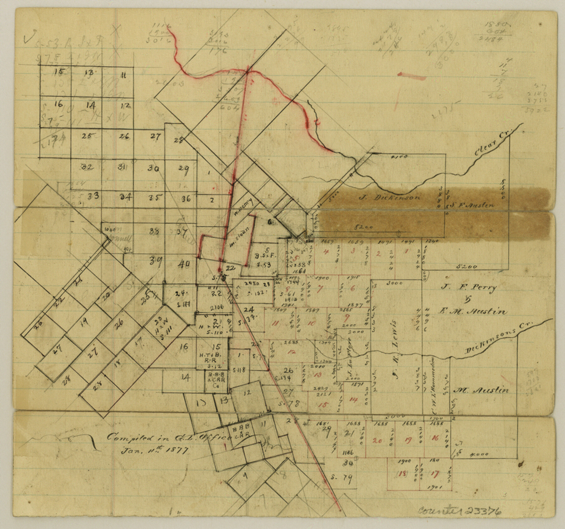
Galveston County Sketch File 11a
[Sketch showing I. & G. N. RR. Co. locations and surrounding surveys in northwest part of Galveston County]
-
Map/Doc
23376
-
Collection
General Map Collection
-
Object Dates
1/11/1877 (Creation Date)
-
People and Organizations
Chas. W. Pressler (Surveyor/Engineer)
-
Counties
Galveston Brazoria
-
Subjects
Surveying Sketch File
-
Height x Width
7.8 x 8.4 inches
19.8 x 21.3 cm
-
Medium
paper, manuscript
-
Features
Clear Creek
Dickinson's Creek
Part of: General Map Collection
Coast Chart No. 210 Aransas Pass and Corpus Christi Bay with the coast to latitude 27° 12' Texas

Print $20.00
- Digital $50.00
Coast Chart No. 210 Aransas Pass and Corpus Christi Bay with the coast to latitude 27° 12' Texas
1887
Size 27.5 x 18.4 inches
Map/Doc 72786
Orange County NRC Article 33.136 Sketch 1

Print $20.00
- Digital $50.00
Orange County NRC Article 33.136 Sketch 1
2004
Size 23.8 x 34.5 inches
Map/Doc 81979
Angelina County Working Sketch 22b

Print $20.00
- Digital $50.00
Angelina County Working Sketch 22b
1953
Size 21.5 x 19.6 inches
Map/Doc 67104
Jackson County Sketch File 14

Print $40.00
- Digital $50.00
Jackson County Sketch File 14
Size 22.2 x 9.8 inches
Map/Doc 27660
Cottle County Sketch File 15

Print $4.00
- Digital $50.00
Cottle County Sketch File 15
1891
Size 11.2 x 9.0 inches
Map/Doc 19516
Bowie County Working Sketch 20

Print $20.00
- Digital $50.00
Bowie County Working Sketch 20
1965
Size 33.0 x 31.9 inches
Map/Doc 67424
[Galveston, Harrisburg & San Antonio through El Paso County]
![64005, [Galveston, Harrisburg & San Antonio through El Paso County], General Map Collection](https://historictexasmaps.com/wmedia_w700/maps/64005.tif.jpg)
Print $20.00
- Digital $50.00
[Galveston, Harrisburg & San Antonio through El Paso County]
1906
Size 13.3 x 33.6 inches
Map/Doc 64005
Travis County Sketch File 26

Print $4.00
- Digital $50.00
Travis County Sketch File 26
1876
Size 12.9 x 8.5 inches
Map/Doc 38336
Corpus Christi Bay

Print $20.00
- Digital $50.00
Corpus Christi Bay
1973
Size 36.6 x 47.7 inches
Map/Doc 73474
Maps of Gulf Intracoastal Waterway, Texas - Sabine River to the Rio Grande and connecting waterways including ship channels

Print $20.00
- Digital $50.00
Maps of Gulf Intracoastal Waterway, Texas - Sabine River to the Rio Grande and connecting waterways including ship channels
1966
Size 14.5 x 22.2 inches
Map/Doc 61922
Crockett County Working Sketch 29

Print $40.00
- Digital $50.00
Crockett County Working Sketch 29
1924
Size 42.8 x 57.6 inches
Map/Doc 68362
Brazos River, Darrington-Ramsey Farms Project

Print $20.00
- Digital $50.00
Brazos River, Darrington-Ramsey Farms Project
1930
Size 37.5 x 26.8 inches
Map/Doc 69677
You may also like

McLennan County Working Sketch 4

Print $20.00
- Digital $50.00
McLennan County Working Sketch 4
1941
Size 19.2 x 27.9 inches
Map/Doc 70697
Bee County Working Sketch 10

Print $20.00
- Digital $50.00
Bee County Working Sketch 10
1941
Size 41.2 x 20.4 inches
Map/Doc 67260
Kimble County Working Sketch 1

Print $20.00
- Digital $50.00
Kimble County Working Sketch 1
Size 14.7 x 18.3 inches
Map/Doc 70069
Hardin County Sketch File 21

Print $4.00
- Digital $50.00
Hardin County Sketch File 21
Size 11.2 x 8.8 inches
Map/Doc 25140
La Salle County Sketch File 19

Print $32.00
- Digital $50.00
La Salle County Sketch File 19
1885
Size 14.2 x 8.7 inches
Map/Doc 29509
Zapata County Sketch File 2

Print $20.00
- Digital $50.00
Zapata County Sketch File 2
1875
Size 24.3 x 32.8 inches
Map/Doc 12718
Castro County, Texas

Print $20.00
- Digital $50.00
Castro County, Texas
1883
Size 20.8 x 18.7 inches
Map/Doc 682
Nueces County Rolled Sketch 95

Print $20.00
- Digital $50.00
Nueces County Rolled Sketch 95
1983
Size 18.2 x 24.7 inches
Map/Doc 7052
Austin's Register of Families Vol. 2

Austin's Register of Families Vol. 2
Size 13.6 x 10.1 inches
Map/Doc 94250
Kendall County Sketch File 16a

Print $40.00
- Digital $50.00
Kendall County Sketch File 16a
1891
Size 15.3 x 13.7 inches
Map/Doc 28707
Flight Mission No. DAG-24K, Frame 124, Matagorda County

Print $20.00
- Digital $50.00
Flight Mission No. DAG-24K, Frame 124, Matagorda County
1953
Size 18.4 x 22.3 inches
Map/Doc 86542