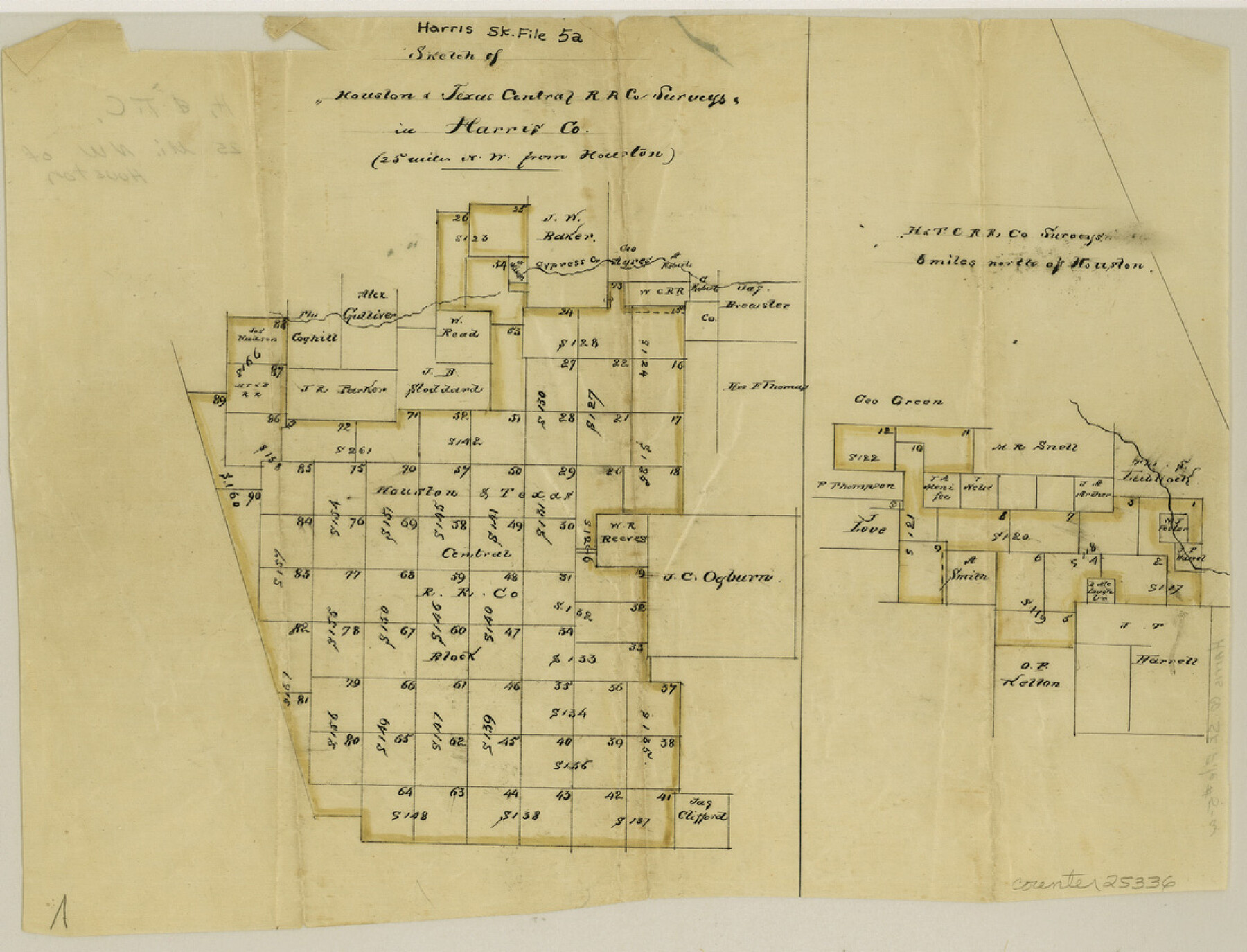
Harris County Sketch File 5a
[Sketches of H. & T. C. RR. Co. surveys in Harris County]
-
Map/Doc
25336
-
Collection
General Map Collection
-
Object Dates
1858/12/22 (File Date)
-
Counties
Harris
-
Subjects
Surveying Sketch File
-
Height x Width
8.4 x 11.0 inches
21.3 x 27.9 cm
-
Medium
paper, manuscript
-
Features
Cypress Creek
Part of: General Map Collection
Copy of Surveyor's Field Book, Morris Browning - In Blocks 7, 5 & 4, I&GNRRCo., Hutchinson and Carson Counties, Texas

Print $2.00
- Digital $50.00
Copy of Surveyor's Field Book, Morris Browning - In Blocks 7, 5 & 4, I&GNRRCo., Hutchinson and Carson Counties, Texas
1888
Size 6.9 x 8.8 inches
Map/Doc 62271
Presidio County Working Sketch 9a

Print $20.00
- Digital $50.00
Presidio County Working Sketch 9a
1933
Size 17.3 x 12.2 inches
Map/Doc 71684
Real County Working Sketch Graphic Index, Sheet 1 (Sketches 1 to 42)

Print $20.00
- Digital $50.00
Real County Working Sketch Graphic Index, Sheet 1 (Sketches 1 to 42)
1972
Size 42.9 x 31.0 inches
Map/Doc 76678
Andrews County Rolled Sketch 8

Print $40.00
- Digital $50.00
Andrews County Rolled Sketch 8
1928
Size 31.4 x 54.0 inches
Map/Doc 8388
Galveston County Aerial Photograph Index Sheet 5

Print $20.00
- Digital $50.00
Galveston County Aerial Photograph Index Sheet 5
1953
Size 23.1 x 18.8 inches
Map/Doc 83696
Highland Lakes 1981 in the scenic Hill Country of Central Texas

Digital $50.00
Highland Lakes 1981 in the scenic Hill Country of Central Texas
1981
Size 11.3 x 16.8 inches
Map/Doc 94174
Gregg County Working Sketch 14

Print $20.00
- Digital $50.00
Gregg County Working Sketch 14
1941
Size 29.7 x 39.5 inches
Map/Doc 63281
Denton County Sketch File 38

Print $26.00
- Digital $50.00
Denton County Sketch File 38
1934
Size 11.4 x 8.9 inches
Map/Doc 20778
Austin County Sketch File 8

Print $40.00
- Digital $50.00
Austin County Sketch File 8
1894
Size 19.3 x 19.9 inches
Map/Doc 10873

Map of Taylor, Bastrop & Houston Railroad in Austin County

Print $20.00
- Digital $50.00
Map of Taylor, Bastrop & Houston Railroad in Austin County
Size 14.6 x 25.1 inches
Map/Doc 64480
Swisher County

Print $20.00
- Digital $50.00
Swisher County
1941
Size 44.3 x 38.1 inches
Map/Doc 73297
You may also like
Pecos County Rolled Sketch 61

Print $20.00
- Digital $50.00
Pecos County Rolled Sketch 61
1925
Size 26.5 x 25.5 inches
Map/Doc 7233
Flight Mission No. BRE-1P, Frame 153, Nueces County

Print $20.00
- Digital $50.00
Flight Mission No. BRE-1P, Frame 153, Nueces County
1956
Size 18.5 x 22.5 inches
Map/Doc 86714
United States - Gulf Coast Texas - Northern part of Laguna Madre

Print $20.00
- Digital $50.00
United States - Gulf Coast Texas - Northern part of Laguna Madre
1923
Size 26.7 x 18.2 inches
Map/Doc 72930
Kerr County Rolled Sketch 24

Print $20.00
- Digital $50.00
Kerr County Rolled Sketch 24
Size 25.1 x 31.4 inches
Map/Doc 6504
The Judicial District/County of Guadalupe. Created, January 29, 1842

Print $20.00
The Judicial District/County of Guadalupe. Created, January 29, 1842
2020
Size 16.7 x 21.7 inches
Map/Doc 96327
Gaines County Sketch File 13

Print $40.00
- Digital $50.00
Gaines County Sketch File 13
1954
Size 8.9 x 20.4 inches
Map/Doc 23200
Padre Island National Seashore

Print $4.00
- Digital $50.00
Padre Island National Seashore
Size 16.0 x 22.2 inches
Map/Doc 60525
Cameron County Rolled Sketch 17

Print $40.00
- Digital $50.00
Cameron County Rolled Sketch 17
1937
Size 49.1 x 37.9 inches
Map/Doc 8570
[Travis District]
![88739, [Travis District], General Map Collection](https://historictexasmaps.com/wmedia_w700/maps/88739.tif.jpg)
Print $40.00
- Digital $50.00
[Travis District]
1840
Size 54.7 x 42.0 inches
Map/Doc 88739
Brown County Sketch File 24

Print $6.00
- Digital $50.00
Brown County Sketch File 24
1889
Size 11.7 x 15.9 inches
Map/Doc 11022

Terrell County Working Sketch Graphic index - sheet B

Print $20.00
- Digital $50.00
Terrell County Working Sketch Graphic index - sheet B
1931
Size 47.7 x 39.6 inches
Map/Doc 76711