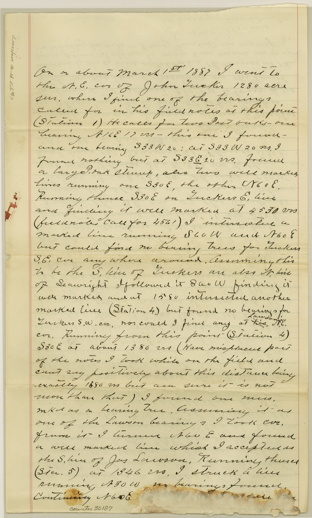
Limestone County Sketch File 17
[Surveyor's sketch and statement southwest of Groesbeck]
-
Map/Doc
30187
-
Collection
General Map Collection
-
Object Dates
8/10/1887 (File Date)
3/1/1887 (Survey Date)
-
People and Organizations
H.W. Williams (Surveyor/Engineer)
S.G. McLendon (Surveyor/Engineer)
R.W. Priest (Surveyor/Engineer)
-
Counties
Limestone
-
Subjects
Surveying Sketch File
-
Height x Width
14.4 x 8.7 inches
36.6 x 22.1 cm
-
Medium
paper, manuscript
Part of: General Map Collection

Gulf Intracoastal Waterway - Texas Erosion at the West End of Bolivar Peninsula Comparative Shorelines

Print $20.00
- Digital $50.00
Gulf Intracoastal Waterway - Texas Erosion at the West End of Bolivar Peninsula Comparative Shorelines
1950
Size 29.0 x 40.3 inches
Map/Doc 61826
Matagorda County Rolled Sketch 26

Print $20.00
- Digital $50.00
Matagorda County Rolled Sketch 26
1950
Size 39.5 x 42.1 inches
Map/Doc 9479
Comanche County Sketch File 19 1/2

Print $6.00
- Digital $50.00
Comanche County Sketch File 19 1/2
1872
Size 8.1 x 7.9 inches
Map/Doc 19098
Knox County Rolled Sketch 25

Print $20.00
- Digital $50.00
Knox County Rolled Sketch 25
2007
Size 11.4 x 10.8 inches
Map/Doc 88749
Travis County Sketch File 77

Print $26.00
- Digital $50.00
Travis County Sketch File 77
2004
Size 11.0 x 8.5 inches
Map/Doc 83254
Ward County Working Sketch 16

Print $20.00
- Digital $50.00
Ward County Working Sketch 16
1948
Size 29.6 x 33.9 inches
Map/Doc 72322
Orange County Working Sketch 5

Print $20.00
- Digital $50.00
Orange County Working Sketch 5
1917
Size 12.6 x 20.6 inches
Map/Doc 71337
Angelina County Working Sketch 33

Print $20.00
- Digital $50.00
Angelina County Working Sketch 33
1955
Size 22.7 x 24.2 inches
Map/Doc 67116
Limestone County Sketch File 18

Print $6.00
- Digital $50.00
Limestone County Sketch File 18
Size 16.0 x 10.7 inches
Map/Doc 30191
La Salle County Working Sketch 12

Print $20.00
- Digital $50.00
La Salle County Working Sketch 12
1929
Size 25.4 x 15.8 inches
Map/Doc 70313
Territory of New Mexico

Print $20.00
- Digital $50.00
Territory of New Mexico
1896
Size 43.4 x 36.5 inches
Map/Doc 76177
You may also like
Northern Part of Laguna Madre

Print $20.00
- Digital $50.00
Northern Part of Laguna Madre
1946
Size 43.8 x 34.5 inches
Map/Doc 73523
Haskell County Rolled Sketch 8

Print $20.00
- Digital $50.00
Haskell County Rolled Sketch 8
1954
Size 43.4 x 47.7 inches
Map/Doc 9146
United States - Gulf Coast - Galveston to Rio Grande

Print $20.00
- Digital $50.00
United States - Gulf Coast - Galveston to Rio Grande
1940
Size 27.0 x 18.2 inches
Map/Doc 72755
Map of Harrison County, Texas

Print $20.00
- Digital $50.00
Map of Harrison County, Texas
1879
Size 20.2 x 21.9 inches
Map/Doc 375
Working Sketch Compiled From Original Field Notes Showing Surveys in Reagan and Irion Counties

Print $20.00
- Digital $50.00
Working Sketch Compiled From Original Field Notes Showing Surveys in Reagan and Irion Counties
Size 36.2 x 20.2 inches
Map/Doc 92331
Jefferson County NRC Article 33.136 Sketch 8

Print $20.00
- Digital $50.00
Jefferson County NRC Article 33.136 Sketch 8
2007
Size 20.1 x 18.7 inches
Map/Doc 87503
[Surveys in the Fannin District: Bois d'Arc Creek, Sulphur Creek]
![263, [Surveys in the Fannin District: Bois d'Arc Creek, Sulphur Creek], General Map Collection](https://historictexasmaps.com/wmedia_w700/maps/263.tif.jpg)
Print $2.00
- Digital $50.00
[Surveys in the Fannin District: Bois d'Arc Creek, Sulphur Creek]
1844
Size 7.9 x 7.9 inches
Map/Doc 263

Mason County Boundary File 6

Print $28.00
- Digital $50.00
Mason County Boundary File 6
Size 14.3 x 8.9 inches
Map/Doc 56874
Pecos County Rolled Sketch 164

Print $20.00
- Digital $50.00
Pecos County Rolled Sketch 164
1965
Size 30.2 x 20.1 inches
Map/Doc 7287
Maps of Gulf Intracoastal Waterway, Texas - Sabine River to the Rio Grande and connecting waterways including ship channels

Print $20.00
- Digital $50.00
Maps of Gulf Intracoastal Waterway, Texas - Sabine River to the Rio Grande and connecting waterways including ship channels
1966
Size 15.7 x 22.0 inches
Map/Doc 61983
The Rand-McNally New Commercial Atlas Map of Texas

Print $20.00
The Rand-McNally New Commercial Atlas Map of Texas
1914
Size 28.6 x 42.4 inches
Map/Doc 78225