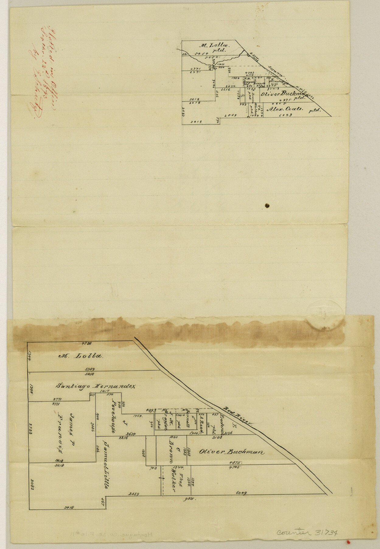
Montague County Sketch File 11
[Office sketch of surveys above the mouth of Saline (Salt) Creek on the south side of Red River]
-
Map/Doc
31734
-
Collection
General Map Collection
-
Object Dates
9/22/1873 (Creation Date)
-
People and Organizations
E. Schutze (Draftsman)
-
Counties
Montague
-
Subjects
Surveying Sketch File
-
Height x Width
12.2 x 8.4 inches
31.0 x 21.3 cm
-
Medium
paper, manuscript
-
Features
Red River
Saline Creek
Part of: General Map Collection
Liberty County Working Sketch 49a

Print $20.00
- Digital $50.00
Liberty County Working Sketch 49a
1955
Size 32.7 x 39.9 inches
Map/Doc 70508
Travis County Sketch File 26

Print $4.00
- Digital $50.00
Travis County Sketch File 26
1876
Size 12.9 x 8.5 inches
Map/Doc 38336
Dimmit County Sketch File 9

Print $6.00
- Digital $50.00
Dimmit County Sketch File 9
Size 8.9 x 11.2 inches
Map/Doc 21070
Kimble County Rolled Sketch 23

Print $20.00
- Digital $50.00
Kimble County Rolled Sketch 23
Size 16.0 x 21.0 inches
Map/Doc 6513
Mitchell County Sketch File 12

Print $20.00
- Digital $50.00
Mitchell County Sketch File 12
1912
Size 25.6 x 14.0 inches
Map/Doc 12099
Colorado County Working Sketch 28

Print $20.00
- Digital $50.00
Colorado County Working Sketch 28
1979
Size 33.5 x 24.3 inches
Map/Doc 68128
Victoria County Sketch File 9

Print $8.00
- Digital $50.00
Victoria County Sketch File 9
1938
Size 14.3 x 8.8 inches
Map/Doc 39530
Floyd County Sketch File 21

Print $20.00
- Digital $50.00
Floyd County Sketch File 21
1914
Size 30.0 x 23.2 inches
Map/Doc 11486
Hutchinson County Rolled Sketch 36B

Print $20.00
- Digital $50.00
Hutchinson County Rolled Sketch 36B
1888
Size 21.1 x 25.3 inches
Map/Doc 6295
Portion of States Submerged Area in Matagorda Bay

Print $20.00
- Digital $50.00
Portion of States Submerged Area in Matagorda Bay
1922
Size 13.9 x 15.9 inches
Map/Doc 2951
Milam County Rolled Sketch 3A

Print $40.00
- Digital $50.00
Milam County Rolled Sketch 3A
1967
Size 49.5 x 43.3 inches
Map/Doc 9522
Township No. 4 South Range No. 16 West of the Indian Meridian

Print $20.00
- Digital $50.00
Township No. 4 South Range No. 16 West of the Indian Meridian
1875
Size 19.4 x 24.4 inches
Map/Doc 75165
You may also like
Terrell County Working Sketch 22a

Print $20.00
- Digital $50.00
Terrell County Working Sketch 22a
1939
Size 39.8 x 40.9 inches
Map/Doc 71493
Flight Mission No. BRE-2P, Frame 12, Nueces County

Print $20.00
- Digital $50.00
Flight Mission No. BRE-2P, Frame 12, Nueces County
1956
Size 18.5 x 22.6 inches
Map/Doc 86721
Ochiltree County School Land League Number 204

Print $20.00
- Digital $50.00
Ochiltree County School Land League Number 204
1926
Size 20.8 x 13.7 inches
Map/Doc 92473
Martin County Working Sketch 6

Print $20.00
- Digital $50.00
Martin County Working Sketch 6
1971
Size 41.8 x 36.9 inches
Map/Doc 70824
Live Oak County

Print $40.00
- Digital $50.00
Live Oak County
1899
Size 52.3 x 38.5 inches
Map/Doc 66905
Kenedy County Aerial Photograph Index Sheet 5

Print $20.00
- Digital $50.00
Kenedy County Aerial Photograph Index Sheet 5
1943
Size 23.5 x 19.6 inches
Map/Doc 89046
Edwards County Sketch File 26

Print $4.00
- Digital $50.00
Edwards County Sketch File 26
1910
Size 11.5 x 9.2 inches
Map/Doc 21753
Montgomery County Working Sketch 65

Print $20.00
- Digital $50.00
Montgomery County Working Sketch 65
1965
Size 21.5 x 16.7 inches
Map/Doc 71172
Flight Mission No. BRA-7M, Frame 142, Jefferson County

Print $20.00
- Digital $50.00
Flight Mission No. BRA-7M, Frame 142, Jefferson County
1953
Size 18.6 x 22.5 inches
Map/Doc 85536
Flight Mission No. CRK-5P, Frame 163, Refugio County

Print $20.00
- Digital $50.00
Flight Mission No. CRK-5P, Frame 163, Refugio County
1956
Size 18.4 x 22.2 inches
Map/Doc 86944
[Rand McNally's Indexed Map of Texas and Indian Territory]
![93992, [Rand McNally's Indexed Map of Texas and Indian Territory], Rees-Jones Digital Map Collection](https://historictexasmaps.com/wmedia_w700/maps/93992.tif.jpg)
Print $20.00
- Digital $50.00
[Rand McNally's Indexed Map of Texas and Indian Territory]
Size 26.0 x 20.6 inches
Map/Doc 93992
Randall County Rolled Sketch 4

Print $20.00
- Digital $50.00
Randall County Rolled Sketch 4
1944
Size 21.7 x 39.7 inches
Map/Doc 7424