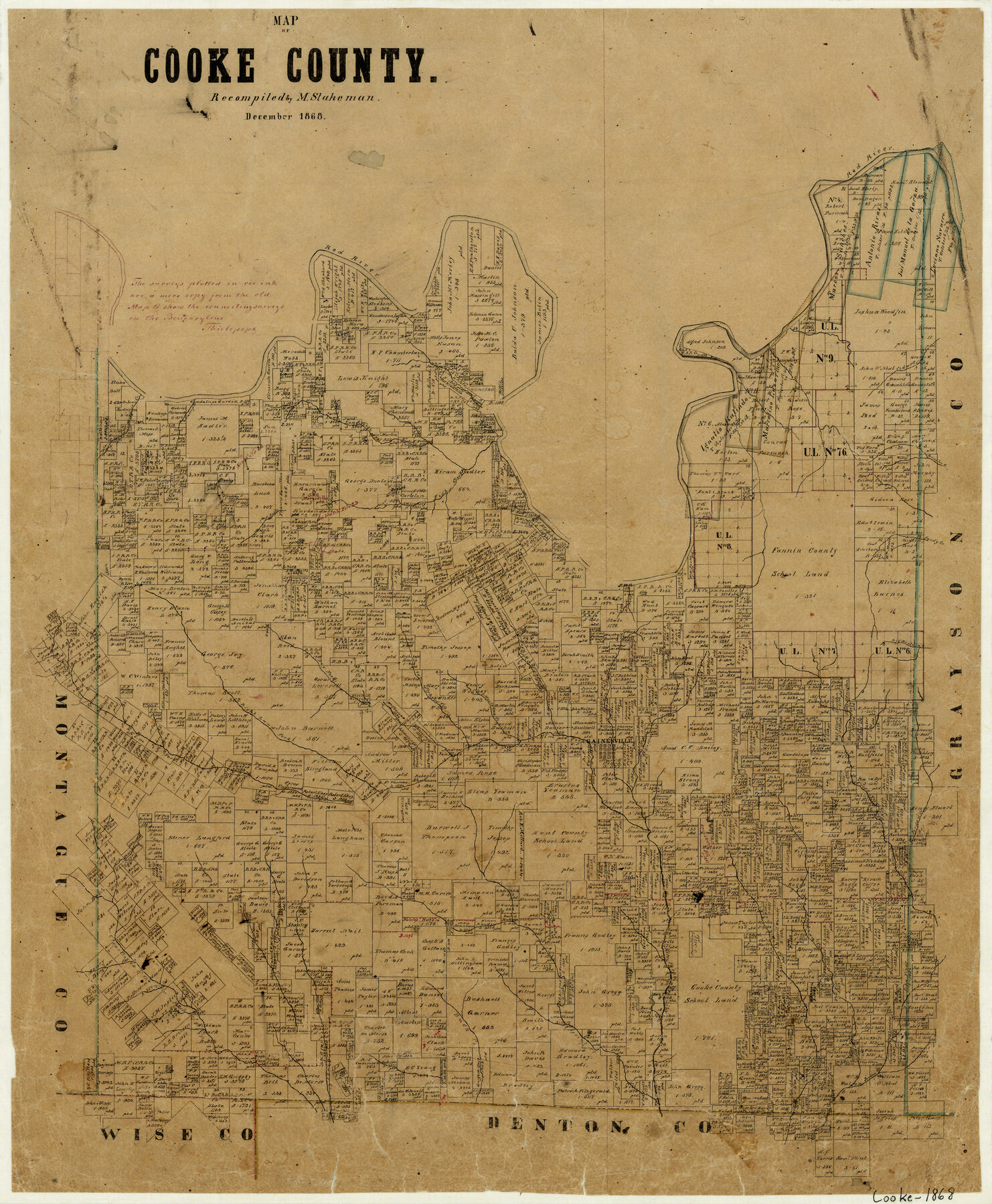
Map of Cooke County
-
Map/Doc
3439
-
Collection
General Map Collection
-
Object Dates
12/1868 (Creation Date)
-
People and Organizations
Max Stakemann (Compiler)
-
Counties
Cooke
-
Subjects
County
-
Height x Width
21.7 x 17.9 inches
55.1 x 45.5 cm
-
Features
Sandy Creek
Indian Creek
Jordan Creek
Wolf Creek
Spring Creek
Duck Creek
Brown Creek
Van Slyke Creek
Montague Creek
Pecan Creek
Big Mountain Creek
Marysville
Mountain Creek
Fish Creek
Cedar Creek of the Elm Fork of Trinity River
Dry Fork of Trinity River
Righthand Fork of Trinity River
Elm Fork of Trinity River
Brushy Fork of Trinity River
Red River
Gainsville
Part of: General Map Collection
Coast Chart No. 212 - From Latitude 26° 33' to the Rio Grande, Texas

Print $20.00
- Digital $50.00
Coast Chart No. 212 - From Latitude 26° 33' to the Rio Grande, Texas
1886
Size 37.8 x 34.1 inches
Map/Doc 73503
Flight Mission No. DAG-24K, Frame 136, Matagorda County

Print $20.00
- Digital $50.00
Flight Mission No. DAG-24K, Frame 136, Matagorda County
1953
Size 18.4 x 22.2 inches
Map/Doc 86554
Hays County Working Sketch 17

Print $20.00
- Digital $50.00
Hays County Working Sketch 17
1971
Size 28.6 x 30.0 inches
Map/Doc 66091
Galveston County Sketch File 7

Print $20.00
- Digital $50.00
Galveston County Sketch File 7
1859
Size 12.8 x 17.0 inches
Map/Doc 23364
San Augustine County Working Sketch 7

Print $20.00
- Digital $50.00
San Augustine County Working Sketch 7
1935
Size 24.7 x 34.8 inches
Map/Doc 63694

Nueces County Rolled Sketch 136

Print $40.00
- Digital $50.00
Nueces County Rolled Sketch 136
2006
Size 37.5 x 50.0 inches
Map/Doc 83556
Falls County Sketch File 31

Print $4.00
- Digital $50.00
Falls County Sketch File 31
1881
Size 14.5 x 8.8 inches
Map/Doc 22439
Flight Mission No. CLL-3N, Frame 33, Willacy County

Print $20.00
- Digital $50.00
Flight Mission No. CLL-3N, Frame 33, Willacy County
1954
Size 18.6 x 22.3 inches
Map/Doc 87090
Southern Part of Laguna Madre

Print $20.00
- Digital $50.00
Southern Part of Laguna Madre
1969
Size 44.4 x 35.4 inches
Map/Doc 73541
La Salle County Sketch File 41

Print $20.00
- Digital $50.00
La Salle County Sketch File 41
1918
Size 25.8 x 15.9 inches
Map/Doc 11986
Flight Mission No. CRC-4R, Frame 172, Chambers County

Print $20.00
- Digital $50.00
Flight Mission No. CRC-4R, Frame 172, Chambers County
1956
Size 18.6 x 22.3 inches
Map/Doc 84923
You may also like
Hydrographic Survey H-6396 of Outer Coast of Padre Island; Gulf of Mexico

Print $40.00
- Digital $50.00
Hydrographic Survey H-6396 of Outer Coast of Padre Island; Gulf of Mexico
1938
Size 54.4 x 33.5 inches
Map/Doc 2699
Rusk County Sketch File 19

Print $4.00
Rusk County Sketch File 19
Size 13.0 x 8.2 inches
Map/Doc 35526
Sterling County Rolled Sketch 27

Print $20.00
- Digital $50.00
Sterling County Rolled Sketch 27
Size 24.0 x 23.2 inches
Map/Doc 7852
Liberty County Rolled Sketch JLW

Print $40.00
- Digital $50.00
Liberty County Rolled Sketch JLW
1935
Size 28.0 x 85.5 inches
Map/Doc 9665
Map of Fort Worth

Print $40.00
- Digital $50.00
Map of Fort Worth
1902
Size 61.3 x 34.8 inches
Map/Doc 93274
Hall County Rolled Sketch 5

Print $20.00
- Digital $50.00
Hall County Rolled Sketch 5
1914
Size 30.2 x 37.1 inches
Map/Doc 6049
San Saba County Working Sketch 1

Print $20.00
- Digital $50.00
San Saba County Working Sketch 1
1919
Size 15.3 x 15.3 inches
Map/Doc 63789
General Highway Map, Mason County, Texas

Print $20.00
General Highway Map, Mason County, Texas
1961
Size 18.3 x 24.8 inches
Map/Doc 79584
Portion of Block Y, W. D. and F. W. Johnson Subdivision Number 2

Print $20.00
- Digital $50.00
Portion of Block Y, W. D. and F. W. Johnson Subdivision Number 2
Size 23.9 x 15.3 inches
Map/Doc 92500
Van Zandt County Sketch File 44

Print $4.00
- Digital $50.00
Van Zandt County Sketch File 44
1858
Size 10.1 x 8.1 inches
Map/Doc 39499
Wise County Sketch File 26b

Print $20.00
- Digital $50.00
Wise County Sketch File 26b
1855
Size 13.3 x 19.9 inches
Map/Doc 12700
Foard County Boundary File 4

Print $24.00
- Digital $50.00
Foard County Boundary File 4
Size 14.2 x 8.8 inches
Map/Doc 53524