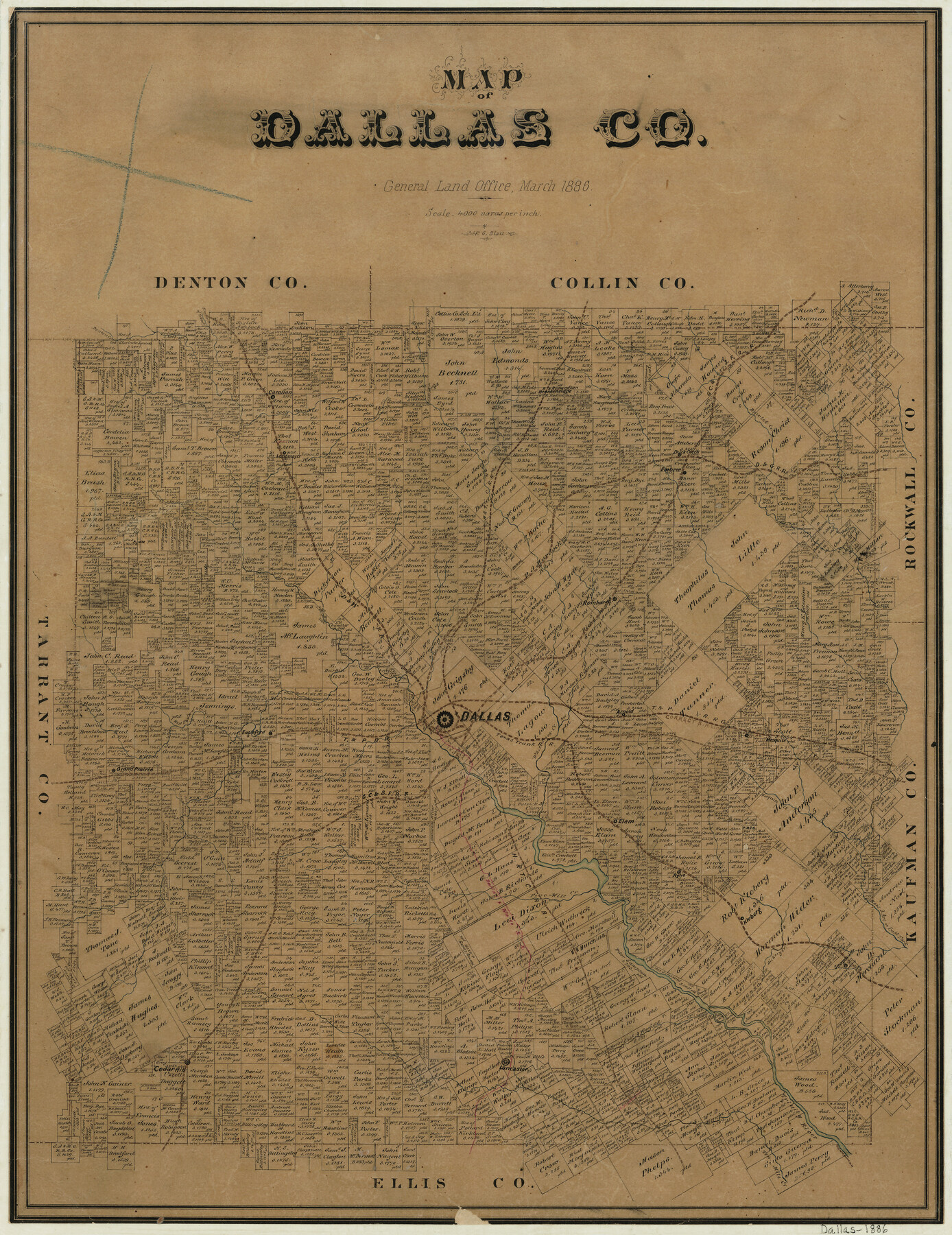
Map of Dallas County
-
Map/Doc
3466
-
Collection
General Map Collection
-
Object Dates
3/1886 (Creation Date)
-
People and Organizations
Texas General Land Office (Publisher)
F.G. Blau (Draftsman)
-
Counties
Dallas
-
Subjects
County
-
Height x Width
21.9 x 17.0 inches
55.6 x 43.2 cm
-
Features
GC&SF
Arnold
White Rock Creek
T&P
Mesquite
Mesquite Creek
Bois D'Arc Creek
Elam
Rylie
Five Mile Creek
Dallas
Grand Prairie
Ten Mile Creek
Hutchins
Kleberg
Hickory Creek
Seagoville
Lancaster
Cedar Hill
Duck Creek
Embree
Elm Fork of Trinity River
Trinity River
Carolton
Langmeyer
Farmer's Creek
H&TC
Breckenridge
TTRR
D&G
Denton Creek
Buck Creek
Rowlet Creek
Reinhard
D&W
Hackberry Creek
East Fork of Trinity River
West Fork of Trinity River
Eagleford
Part of: General Map Collection
Jefferson County Rolled Sketch 39

Print $20.00
- Digital $50.00
Jefferson County Rolled Sketch 39
1885
Size 31.2 x 33.9 inches
Map/Doc 9299
[Missouri, Kansas & Texas] E. L. & R. R. Railroad, Morris Co.
![64273, [Missouri, Kansas & Texas] E. L. & R. R. Railroad, Morris Co., General Map Collection](https://historictexasmaps.com/wmedia_w700/maps/64273.tif.jpg)
Print $20.00
- Digital $50.00
[Missouri, Kansas & Texas] E. L. & R. R. Railroad, Morris Co.
1906
Size 13.1 x 28.4 inches
Map/Doc 64273
Denton County Working Sketch 5

Print $20.00
- Digital $50.00
Denton County Working Sketch 5
1956
Size 23.9 x 19.4 inches
Map/Doc 68610
Topographical Map of the Rio Grande, Sheet No. 1

Print $20.00
- Digital $50.00
Topographical Map of the Rio Grande, Sheet No. 1
1912
Map/Doc 89525
Crane County Rolled Sketch 24

Print $40.00
- Digital $50.00
Crane County Rolled Sketch 24
2002
Size 33.5 x 62.0 inches
Map/Doc 76427
Reeves County Working Sketch 13

Print $20.00
- Digital $50.00
Reeves County Working Sketch 13
1959
Size 30.5 x 33.4 inches
Map/Doc 63456
Map of Montague County

Print $20.00
- Digital $50.00
Map of Montague County
1868
Size 19.9 x 16.9 inches
Map/Doc 3888
Reeves County Rolled Sketch 16

Print $20.00
- Digital $50.00
Reeves County Rolled Sketch 16
1963
Size 22.3 x 27.3 inches
Map/Doc 7485

Baylor County Sketch File A6

Print $80.00
- Digital $50.00
Baylor County Sketch File A6
1899
Size 22.5 x 31.7 inches
Map/Doc 10912
Zapata County Working Sketch 7

Print $40.00
- Digital $50.00
Zapata County Working Sketch 7
1946
Size 42.8 x 53.4 inches
Map/Doc 62058
Hutchinson County Sketch File 17

Print $4.00
- Digital $50.00
Hutchinson County Sketch File 17
Size 6.9 x 8.8 inches
Map/Doc 27218
You may also like
Flight Mission No. DQO-2K, Frame 134, Galveston County

Print $20.00
- Digital $50.00
Flight Mission No. DQO-2K, Frame 134, Galveston County
1952
Size 18.7 x 22.4 inches
Map/Doc 85031
Presidio County Rolled Sketch 6

Print $40.00
- Digital $50.00
Presidio County Rolled Sketch 6
1949
Size 56.8 x 32.2 inches
Map/Doc 9761
El Paso County Working Sketch 59

Print $20.00
- Digital $50.00
El Paso County Working Sketch 59
2000
Size 28.1 x 35.7 inches
Map/Doc 69081
International boundary between the United States and Mexico in the Rio Grande and Colorado River delineated in accordance with the Treaty of November 23, 1970 - Volume 2

International boundary between the United States and Mexico in the Rio Grande and Colorado River delineated in accordance with the Treaty of November 23, 1970 - Volume 2
1974
Size 25.0 x 35.2 inches
Map/Doc 7641
North and South Sulphur Rivers, Sulphur Bluff Sheet

Print $20.00
- Digital $50.00
North and South Sulphur Rivers, Sulphur Bluff Sheet
1933
Size 37.6 x 37.2 inches
Map/Doc 65163
La Salle County Sketch File 11

Print $20.00
- Digital $50.00
La Salle County Sketch File 11
1877
Size 12.7 x 8.1 inches
Map/Doc 29460

[Palmer and Castro Counties]
![1763, [Palmer and Castro Counties], General Map Collection](https://historictexasmaps.com/wmedia_w700/maps/1763-1.tif.jpg)
Print $20.00
- Digital $50.00
[Palmer and Castro Counties]
1910
Size 19.3 x 26.3 inches
Map/Doc 1763
Map of the Country Upon the Brazos and Big Wichita Rivers Embracing the Lands appropriated by the State of Texas for the Use of the Indians

Print $20.00
Map of the Country Upon the Brazos and Big Wichita Rivers Embracing the Lands appropriated by the State of Texas for the Use of the Indians
1854
Size 28.8 x 32.3 inches
Map/Doc 76284
Tarrant County Sketch File 10

Print $8.00
- Digital $50.00
Tarrant County Sketch File 10
1859
Size 12.9 x 8.4 inches
Map/Doc 37694
Right of Way and Track Map, International & Gt. Northern Ry. Operated by the International & Gt. Northern Ry. Co., Gulf Division

Print $40.00
- Digital $50.00
Right of Way and Track Map, International & Gt. Northern Ry. Operated by the International & Gt. Northern Ry. Co., Gulf Division
1917
Size 25.1 x 56.6 inches
Map/Doc 64252
Newton County Working Sketch 9

Print $20.00
- Digital $50.00
Newton County Working Sketch 9
1938
Size 21.3 x 37.1 inches
Map/Doc 71255