Webb County Sketch File C1
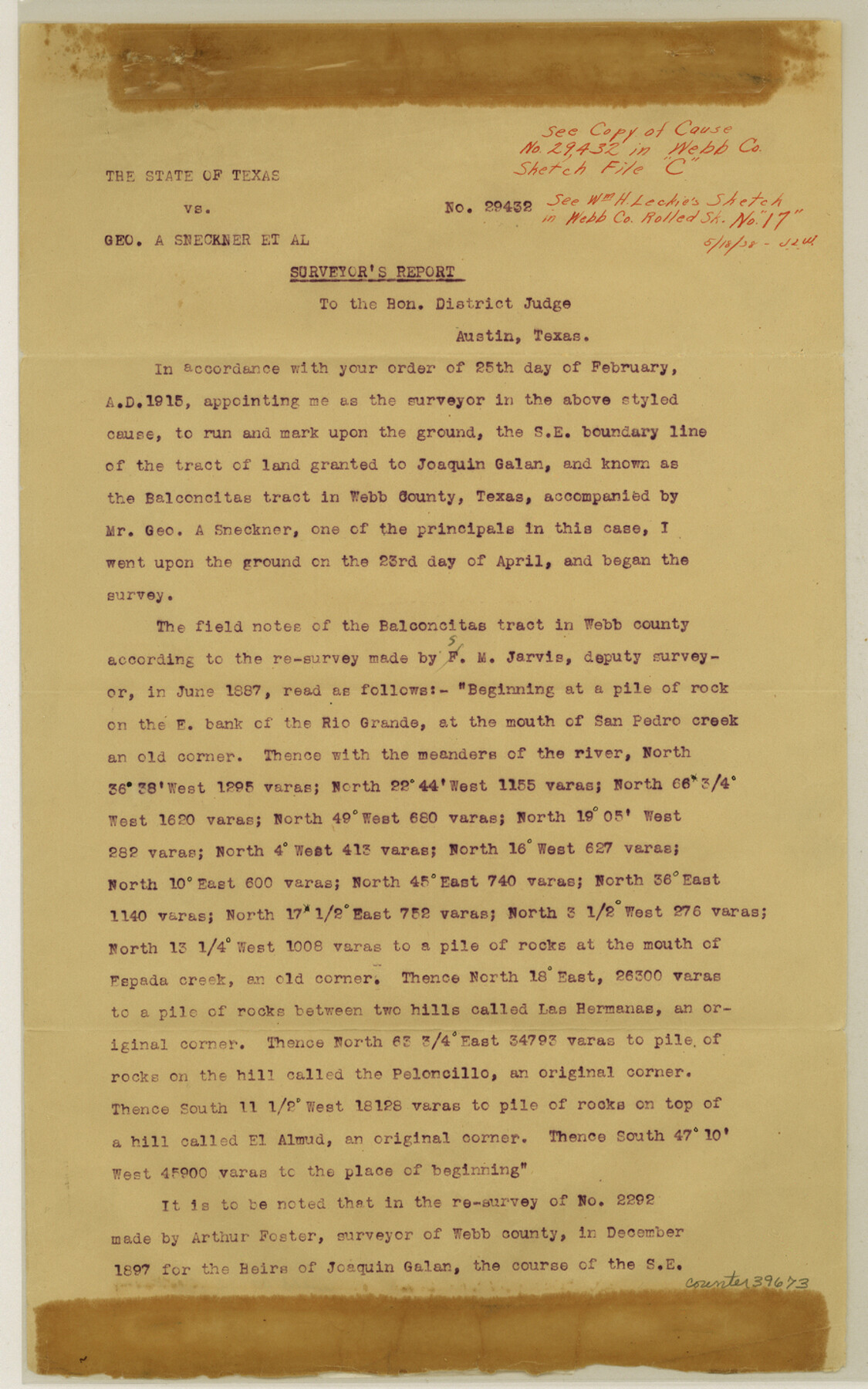
[Surveyor's Report - Cause no. 29432 - the State of Texas vs. George A. Sneckner, et al]
-
Map/Doc
39673
-
Collection
General Map Collection
-
Object Dates
6/10/1915 (Creation Date)
5/18/1938 (File Date)
-
People and Organizations
Wm. H. Leckie (Surveyor/Engineer)
-
Counties
Webb
-
Subjects
Surveying Sketch File
-
Height x Width
14.3 x 8.9 inches
36.3 x 22.6 cm
-
Medium
paper, print
-
Comments
See Webb County Sketch File C (39668) for judgement and see Webb County Rolled Sketch 17 (8180) for sketch.
-
Features
San Pedro Creek
Rio Grande
Los Hermanas [Hills]
Peloncillo Hill
Sauz Creek
San Pedro Creek
Laredo & Asherton Road
Santa Isabel Creek
Related maps
Webb County Sketch File C

Print $10.00
- Digital $50.00
Webb County Sketch File C
1915
Size 14.4 x 8.8 inches
Map/Doc 39668
Webb County Rolled Sketch 17

Print $20.00
- Digital $50.00
Webb County Rolled Sketch 17
1915
Size 16.7 x 14.7 inches
Map/Doc 8180
Part of: General Map Collection

Flight Mission No. BQR-5K, Frame 63, Brazoria County

Print $20.00
- Digital $50.00
Flight Mission No. BQR-5K, Frame 63, Brazoria County
1952
Size 19.0 x 22.6 inches
Map/Doc 84008
Pecos County Working Sketch 114

Print $40.00
- Digital $50.00
Pecos County Working Sketch 114
1972
Size 75.7 x 38.0 inches
Map/Doc 71587
Jefferson County NRC Article 33.136 Sketch 9

Print $22.00
- Digital $50.00
Jefferson County NRC Article 33.136 Sketch 9
2011
Size 24.0 x 36.0 inches
Map/Doc 94517
Webb County Rolled Sketch 2

Print $20.00
- Digital $50.00
Webb County Rolled Sketch 2
1881
Size 19.4 x 27.6 inches
Map/Doc 8169

Tarrant County Boundary File 2a

Print $62.00
- Digital $50.00
Tarrant County Boundary File 2a
Size 9.0 x 4.8 inches
Map/Doc 59114
Pecos County Rolled Sketch 140

Print $20.00
- Digital $50.00
Pecos County Rolled Sketch 140
1954
Size 28.4 x 38.6 inches
Map/Doc 7275
Dawson County Rolled Sketch 5

Print $20.00
- Digital $50.00
Dawson County Rolled Sketch 5
1913
Size 33.6 x 28.0 inches
Map/Doc 5691
Mills County Boundary File 9

Print $40.00
- Digital $50.00
Mills County Boundary File 9
Size 13.7 x 8.6 inches
Map/Doc 57318
Coast Chart No. 209 - Aransas Pass, Aransas and Copano Bays, Texas

Print $20.00
- Digital $50.00
Coast Chart No. 209 - Aransas Pass, Aransas and Copano Bays, Texas
1906
Size 40.2 x 33.8 inches
Map/Doc 73430
Val Verde County Working Sketch 27

Print $20.00
- Digital $50.00
Val Verde County Working Sketch 27
1937
Size 26.6 x 26.4 inches
Map/Doc 72162
You may also like
Flight Mission No. BRA-8M, Frame 69, Jefferson County

Print $20.00
- Digital $50.00
Flight Mission No. BRA-8M, Frame 69, Jefferson County
1953
Size 18.6 x 22.1 inches
Map/Doc 85589
Galveston County Rolled Sketch HB

Print $40.00
- Digital $50.00
Galveston County Rolled Sketch HB
1936
Size 65.4 x 33.3 inches
Map/Doc 9085
Flight Mission No. CUG-2P, Frame 82, Kleberg County

Print $20.00
- Digital $50.00
Flight Mission No. CUG-2P, Frame 82, Kleberg County
1956
Size 18.5 x 22.3 inches
Map/Doc 86214
Chambers County Sketch File 9

Print $10.00
- Digital $50.00
Chambers County Sketch File 9
1872
Size 10.3 x 11.8 inches
Map/Doc 17546
Young County Working Sketch 6

Print $20.00
- Digital $50.00
Young County Working Sketch 6
1919
Size 12.2 x 11.9 inches
Map/Doc 62029
Hale County Working Sketch 6

Print $40.00
- Digital $50.00
Hale County Working Sketch 6
1963
Size 68.9 x 38.8 inches
Map/Doc 63326

City of Alpine - Texas, Brewster County

Print $20.00
- Digital $50.00
City of Alpine - Texas, Brewster County
1945
Size 11.4 x 19.4 inches
Map/Doc 1683
Coast Chart No. 211 - Padre I. and Laguna Madre, Lat. 27° 12' to Lat. 26° 33', Texas

Print $20.00
- Digital $50.00
Coast Chart No. 211 - Padre I. and Laguna Madre, Lat. 27° 12' to Lat. 26° 33', Texas
1890
Size 41.0 x 33.4 inches
Map/Doc 73501
Val Verde Co.

Print $20.00
- Digital $50.00
Val Verde Co.
1908
Size 39.8 x 38.7 inches
Map/Doc 63100
[Blocks O3 and O4 and Capitol Leagues in the vicinity]
![90391, [Blocks O3 and O4 and Capitol Leagues in the vicinity], Twichell Survey Records](https://historictexasmaps.com/wmedia_w700/maps/90391-1.tif.jpg)
Print $2.00
- Digital $50.00
[Blocks O3 and O4 and Capitol Leagues in the vicinity]
Size 8.4 x 10.5 inches
Map/Doc 90391
[Northwest part of the County]
![90841, [Northwest part of the County], Twichell Survey Records](https://historictexasmaps.com/wmedia_w700/maps/90841-2.tif.jpg)
Print $20.00
- Digital $50.00
[Northwest part of the County]
Size 17.9 x 34.9 inches
Map/Doc 90841