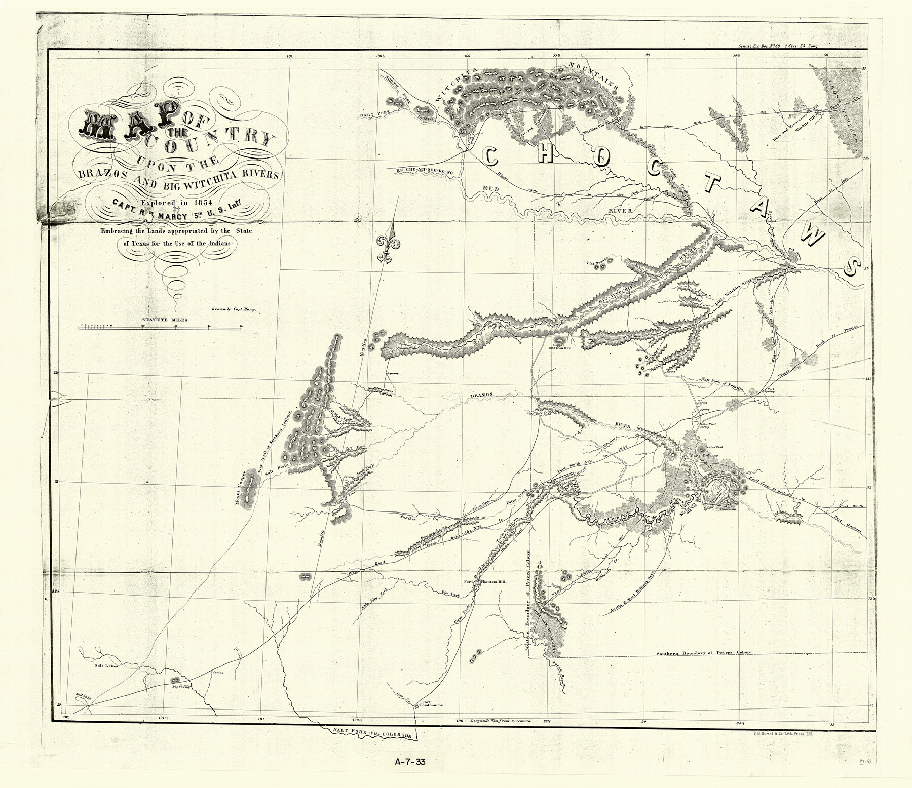
Map of the country upon the Brazos and Big Witchita Rivers
A-7-33
-
Map/Doc
4663
-
Collection
General Map Collection
-
Object Dates
1854 (Creation Date)
-
People and Organizations
Capt. Marcy (Draftsman)
Capt. Marcy (Author)
-
Height x Width
30.3 x 34.9 inches
77.0 x 88.7 cm
-
Comments
Embracing the lands appropriatd by the State of Texas for the use of the Indians.
Explored in 1854 by Capt. Marcy, 5th U. S. Infantry.
Shows the Western boundary and part of the Southern boundary of Peter's Colony.
Part of: General Map Collection
Haskell County Sketch File 8

Print $20.00
- Digital $50.00
Haskell County Sketch File 8
Size 28.3 x 24.7 inches
Map/Doc 11740
Harris County Rolled Sketch 70

Print $20.00
- Digital $50.00
Harris County Rolled Sketch 70
1942
Size 29.6 x 36.2 inches
Map/Doc 6110
Concho County Sketch File 21

Print $6.00
- Digital $50.00
Concho County Sketch File 21
Size 7.3 x 11.1 inches
Map/Doc 19143
La Salle County Sketch File 20

Print $34.00
- Digital $50.00
La Salle County Sketch File 20
1887
Size 13.6 x 8.7 inches
Map/Doc 29519
Harrison County Sketch File 20

Print $20.00
- Digital $50.00
Harrison County Sketch File 20
1946
Size 26.4 x 21.8 inches
Map/Doc 11693
Stephens County Sketch File 24

Print $5.00
- Digital $50.00
Stephens County Sketch File 24
1952
Size 24.5 x 32.5 inches
Map/Doc 12354
Intracoastal Waterway - Laguna Madre - Chubby Island to Stover Point including the Arroyo Colorado, Texas

Print $20.00
- Digital $50.00
Intracoastal Waterway - Laguna Madre - Chubby Island to Stover Point including the Arroyo Colorado, Texas
1976
Size 15.6 x 43.8 inches
Map/Doc 75900
Nolan County Sketch File B

Print $20.00
- Digital $50.00
Nolan County Sketch File B
1902
Size 12.0 x 21.5 inches
Map/Doc 42171
Dimmit County Sketch File 25

Print $4.00
- Digital $50.00
Dimmit County Sketch File 25
1885
Size 12.9 x 8.6 inches
Map/Doc 21142
Brazoria County Working Sketch 49a

Print $20.00
- Digital $50.00
Brazoria County Working Sketch 49a
2003
Size 35.0 x 35.0 inches
Map/Doc 78347
Hunt County Sketch File 49

Print $4.00
- Digital $50.00
Hunt County Sketch File 49
1852
Size 7.3 x 8.9 inches
Map/Doc 27168
La Salle County Rolled Sketch 17

Print $20.00
- Digital $50.00
La Salle County Rolled Sketch 17
Size 26.5 x 29.9 inches
Map/Doc 6581
You may also like
Flight Mission No. CUG-3P, Frame 24, Kleberg County

Print $20.00
- Digital $50.00
Flight Mission No. CUG-3P, Frame 24, Kleberg County
1956
Size 18.4 x 22.3 inches
Map/Doc 86234
McMullen County Sketch File 2

Print $22.00
- Digital $50.00
McMullen County Sketch File 2
1849
Size 8.3 x 12.4 inches
Map/Doc 31337
Shackelford County Boundary File 4

Print $2.00
- Digital $50.00
Shackelford County Boundary File 4
Size 6.6 x 8.8 inches
Map/Doc 58660
The Republic County of Jasper. December 29, 1845

Print $20.00
The Republic County of Jasper. December 29, 1845
2020
Size 19.5 x 21.7 inches
Map/Doc 96196
Galveston County NRC Article 33.136 Location Key Sheet

Print $20.00
- Digital $50.00
Galveston County NRC Article 33.136 Location Key Sheet
1994
Size 27.0 x 22.0 inches
Map/Doc 77020
Kaufman County Sketch File 12

Print $4.00
- Digital $50.00
Kaufman County Sketch File 12
1862
Size 12.9 x 8.2 inches
Map/Doc 28647
Hardin County Working Sketch 34

Print $20.00
- Digital $50.00
Hardin County Working Sketch 34
1980
Size 15.7 x 12.1 inches
Map/Doc 63432
Revised Sectional Map Number 2, Lands in Texas and Pacific Railway Reservation From Westbrook Station in Mitchell County to Metz Station in Ector County

Print $20.00
- Digital $50.00
Revised Sectional Map Number 2, Lands in Texas and Pacific Railway Reservation From Westbrook Station in Mitchell County to Metz Station in Ector County
Size 25.1 x 19.6 inches
Map/Doc 91366
Bexar County Sketch File 59

Print $4.00
- Digital $50.00
Bexar County Sketch File 59
Size 10.2 x 8.1 inches
Map/Doc 14576
Cottle County Rolled Sketch OX

Print $20.00
- Digital $50.00
Cottle County Rolled Sketch OX
1916
Size 29.6 x 35.8 inches
Map/Doc 8673
Hudspeth County Sketch File 22

Print $10.00
- Digital $50.00
Hudspeth County Sketch File 22
1935
Size 11.2 x 8.7 inches
Map/Doc 26974
Matagorda County Sketch File 33

Print $6.00
- Digital $50.00
Matagorda County Sketch File 33
1938
Size 14.2 x 8.8 inches
Map/Doc 30817