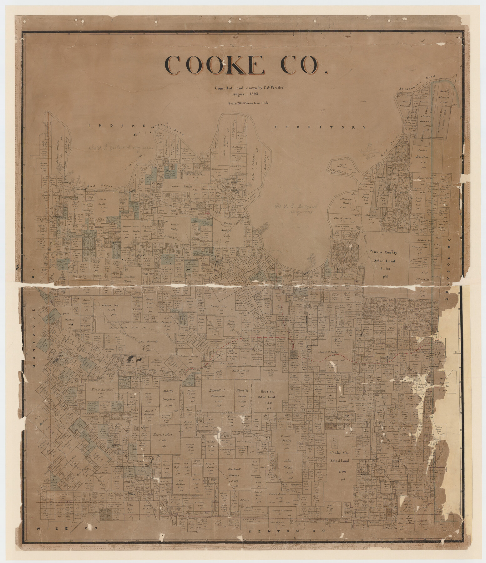
Cooke Co.
-
Map/Doc
4732
-
Collection
General Map Collection
-
Object Dates
1895 (Creation Date)
-
People and Organizations
Texas General Land Office (Publisher)
Chas. W. Pressler (Draftsman)
Chas. W. Pressler (Compiler)
-
Counties
Cooke
-
Subjects
County
-
Height x Width
44.0 x 38.0 inches
111.8 x 96.5 cm
-
Comments
Partially adopted and conservation funded in 2005 by Beth and James Fitzgerald in honor of Wauscel Larue Barshop and Lee - Bourland Camp 1848, Sons of Confederate Veterans and Friends of the Texas General Land Office.
-
Features
Indian Creek
Dosier's Creek
Elm Fork of Trinity River
Dry Fork of Trinity River
Righthand Fork of Trinity River
Montague Creek
Gainsville
Van Slyke's Creek
Tonkaway Creek
Pecan Creek
Jordan's Creek
Wolf Creek
Finley's Creek
Clear Creek
Gray's Creek
Duck Creek
Spring Creek
Mountain Creek
Red River
Warren's Bend of Red River
Swills Bend of Red River
Alexander's Bend of Red River
Rock Creek
Dexter
Bearhead Creek
Cedar Creek
Valley Creek
Camp Creek
Fish Creek
South Prong of Fish Creek
North Prong of Fish Creek
Hickory Creek
Marysville
Brown's Creek
Part of: General Map Collection
Castro County Sketch File 4g

Print $4.00
- Digital $50.00
Castro County Sketch File 4g
Size 12.0 x 8.9 inches
Map/Doc 17477
Culberson County Rolled Sketch 52

Print $20.00
- Digital $50.00
Culberson County Rolled Sketch 52
Size 19.1 x 24.7 inches
Map/Doc 5672
Orange County Working Sketch 29

Print $40.00
- Digital $50.00
Orange County Working Sketch 29
1953
Size 32.9 x 50.0 inches
Map/Doc 71361

Loving County Rolled Sketch 8

Print $20.00
- Digital $50.00
Loving County Rolled Sketch 8
1975
Size 30.5 x 17.4 inches
Map/Doc 6639
Flight Mission No. DQN-1K, Frame 151, Calhoun County

Print $20.00
- Digital $50.00
Flight Mission No. DQN-1K, Frame 151, Calhoun County
1953
Size 18.6 x 22.3 inches
Map/Doc 84210
Baseline Parcels 83 - Superconducting Super Collider

Print $20.00
- Digital $50.00
Baseline Parcels 83 - Superconducting Super Collider
1991
Size 31.0 x 39.2 inches
Map/Doc 93676
Right of Way & Track Map, St. Louis, Brownsville & Mexico Ry. operated by St. Louis, Brownsville & Mexico Ry. Co.

Print $40.00
- Digital $50.00
Right of Way & Track Map, St. Louis, Brownsville & Mexico Ry. operated by St. Louis, Brownsville & Mexico Ry. Co.
1919
Size 25.4 x 57.1 inches
Map/Doc 64618
Crockett County Working Sketch 98

Print $20.00
- Digital $50.00
Crockett County Working Sketch 98
1980
Size 42.8 x 35.9 inches
Map/Doc 68431
Galveston County Working Sketch 21

Print $20.00
- Digital $50.00
Galveston County Working Sketch 21
1987
Size 28.9 x 23.9 inches
Map/Doc 69358
Map of Terry County

Print $20.00
- Digital $50.00
Map of Terry County
1901
Size 43.1 x 39.8 inches
Map/Doc 16892
Andrews County Rolled Sketch 30

Print $20.00
- Digital $50.00
Andrews County Rolled Sketch 30
Size 20.6 x 18.1 inches
Map/Doc 77174
You may also like

Red River County Sketch File 17

Print $26.00
- Digital $50.00
Red River County Sketch File 17
1868
Size 12.8 x 8.2 inches
Map/Doc 35141
[Block N and part of Block B]
![90363, [Block N and part of Block B], Twichell Survey Records](https://historictexasmaps.com/wmedia_w700/maps/90363-1.tif.jpg)
Print $3.00
- Digital $50.00
[Block N and part of Block B]
Size 9.6 x 12.8 inches
Map/Doc 90363
Zapata County Rolled Sketch 12A

Print $40.00
- Digital $50.00
Zapata County Rolled Sketch 12A
1917
Size 54.0 x 40.0 inches
Map/Doc 10165
Plat of Location and Right of Way from El Paso, Tex. To New Mexico Line, Rio Grande and El Paso R. R.

Print $40.00
- Digital $50.00
Plat of Location and Right of Way from El Paso, Tex. To New Mexico Line, Rio Grande and El Paso R. R.
Size 22.5 x 121.3 inches
Map/Doc 64083
Taylor County Rolled Sketch 21

Print $20.00
- Digital $50.00
Taylor County Rolled Sketch 21
Size 31.5 x 40.5 inches
Map/Doc 9985
Map of Montague County

Print $20.00
- Digital $50.00
Map of Montague County
1868
Size 19.9 x 16.9 inches
Map/Doc 3888
Angelina County Working Sketch 23

Print $20.00
- Digital $50.00
Angelina County Working Sketch 23
1953
Size 19.8 x 32.6 inches
Map/Doc 67105

Flight Mission No. BRA-16M, Frame 176, Jefferson County

Print $20.00
- Digital $50.00
Flight Mission No. BRA-16M, Frame 176, Jefferson County
1953
Size 18.7 x 22.3 inches
Map/Doc 85774

