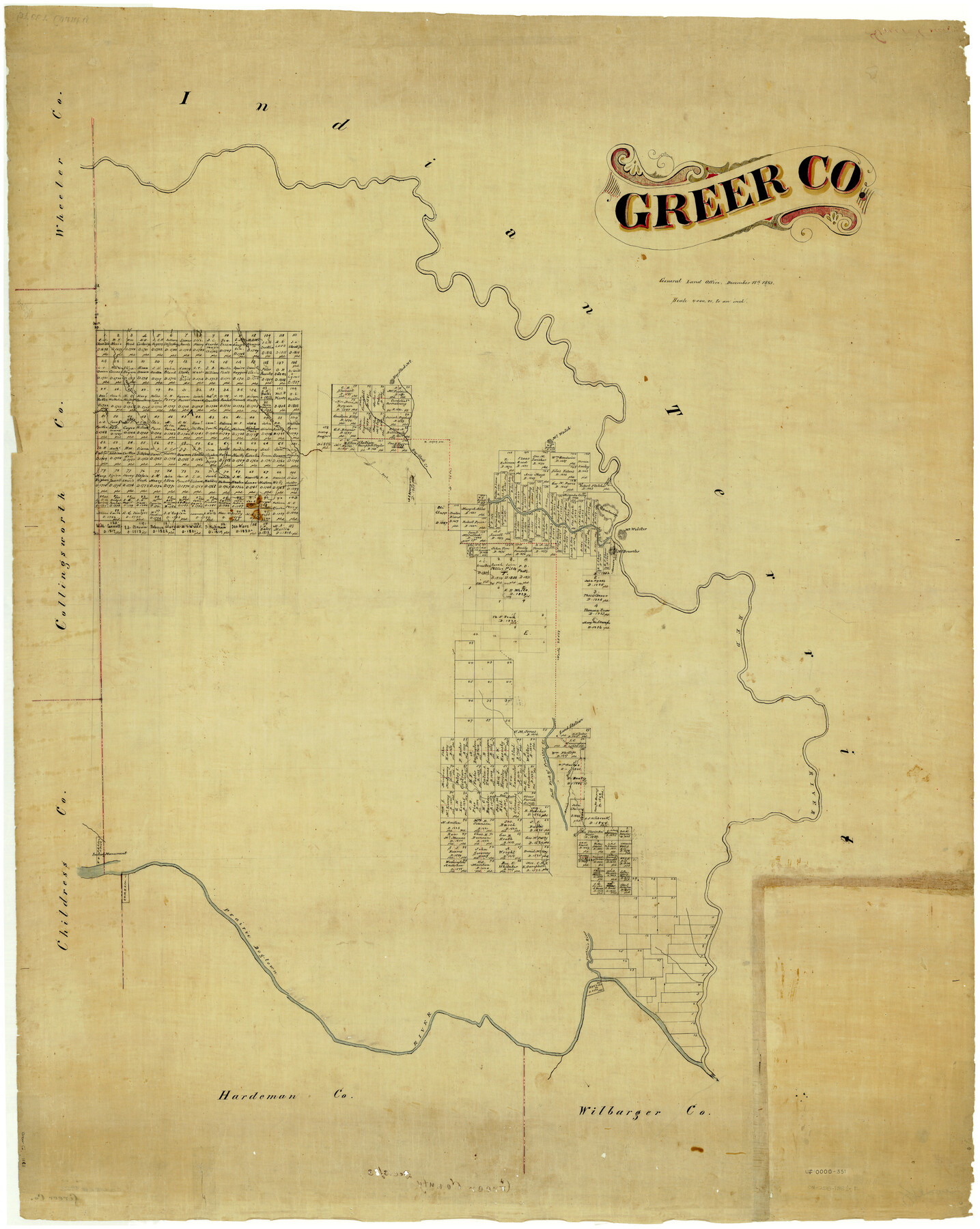
Greer Co.
-
Map/Doc
4962
-
Collection
General Map Collection
-
Object Dates
12/18/1883 (Creation Date)
-
People and Organizations
Texas General Land Office (Publisher)
-
Counties
Greer
-
Subjects
County
-
Height x Width
44.0 x 33.9 inches
111.8 x 86.1 cm
-
Comments
This land is now part of Oklahoma.
Part of: General Map Collection
Upton County Rolled Sketch 41

Print $20.00
- Digital $50.00
Upton County Rolled Sketch 41
Size 27.4 x 40.8 inches
Map/Doc 8080
[Surveys in the Bexar District along the San Antonio River showing the position of the missions]
![125, [Surveys in the Bexar District along the San Antonio River showing the position of the missions], General Map Collection](https://historictexasmaps.com/wmedia_w700/maps/125.tif.jpg)
Print $3.00
- Digital $50.00
[Surveys in the Bexar District along the San Antonio River showing the position of the missions]
1841
Size 11.2 x 16.0 inches
Map/Doc 125
Mills County Rolled Sketch 2

Print $20.00
- Digital $50.00
Mills County Rolled Sketch 2
1974
Size 24.1 x 22.8 inches
Map/Doc 6780
Castro County Working Sketch 5

Print $20.00
- Digital $50.00
Castro County Working Sketch 5
1943
Size 11.9 x 18.3 inches
Map/Doc 67900
Coast Chart No. 210 - Aransas Pass and Corpus Christi Bay with the coast to latitude 27° 12', Texas

Print $20.00
- Digital $50.00
Coast Chart No. 210 - Aransas Pass and Corpus Christi Bay with the coast to latitude 27° 12', Texas
1887
Size 30.4 x 24.0 inches
Map/Doc 73444
Wood County Sketch File 5

Print $4.00
- Digital $50.00
Wood County Sketch File 5
1848
Size 10.7 x 9.0 inches
Map/Doc 40637
Randall County Boundary File 2

Print $14.00
- Digital $50.00
Randall County Boundary File 2
Size 8.9 x 7.9 inches
Map/Doc 58111
Blanco County

Print $40.00
- Digital $50.00
Blanco County
1916
Size 48.7 x 35.7 inches
Map/Doc 66715
Menard County Working Sketch 18

Print $20.00
- Digital $50.00
Menard County Working Sketch 18
1946
Size 30.6 x 31.0 inches
Map/Doc 70965
Flight Mission No. BRA-6M, Frame 97, Jefferson County

Print $20.00
- Digital $50.00
Flight Mission No. BRA-6M, Frame 97, Jefferson County
1953
Size 18.7 x 22.3 inches
Map/Doc 85440
Harris County Working Sketch 9

Print $20.00
- Digital $50.00
Harris County Working Sketch 9
1908
Size 27.7 x 39.4 inches
Map/Doc 65901
Gregg County Boundary File 6

Print $6.00
- Digital $50.00
Gregg County Boundary File 6
Size 8.5 x 5.8 inches
Map/Doc 54001
You may also like
Nueces County Sketch File 74

Print $28.00
- Digital $50.00
Nueces County Sketch File 74
1951
Size 10.1 x 15.4 inches
Map/Doc 33028
Upshur County

Print $20.00
- Digital $50.00
Upshur County
1945
Size 39.9 x 35.3 inches
Map/Doc 95658
Magnetic Declination in the United States - Epoch 1980

Print $20.00
- Digital $50.00
Magnetic Declination in the United States - Epoch 1980
1980
Size 41.4 x 33.3 inches
Map/Doc 92368
San Augustine County Working Sketch 17

Print $20.00
- Digital $50.00
San Augustine County Working Sketch 17
1963
Size 20.3 x 21.5 inches
Map/Doc 63705
Map of San Jacinto County

Print $20.00
- Digital $50.00
Map of San Jacinto County
1872
Size 22.0 x 18.6 inches
Map/Doc 1346
Flight Mission No. CRC-3R, Frame 35, Chambers County

Print $20.00
- Digital $50.00
Flight Mission No. CRC-3R, Frame 35, Chambers County
1956
Size 18.5 x 22.2 inches
Map/Doc 84808
Flight Mission No. CUG-2P, Frame 10, Kleberg County

Print $20.00
- Digital $50.00
Flight Mission No. CUG-2P, Frame 10, Kleberg County
1956
Size 18.7 x 22.3 inches
Map/Doc 86182
Pecos County Sketch File 28a

Print $20.00
- Digital $50.00
Pecos County Sketch File 28a
Size 24.3 x 26.6 inches
Map/Doc 12169
Cottle County Sketch File 6b

Print $2.00
- Digital $50.00
Cottle County Sketch File 6b
Size 8.8 x 14.1 inches
Map/Doc 19477
Flight Mission No. DCL-4C, Frame 70, Kenedy County

Print $20.00
- Digital $50.00
Flight Mission No. DCL-4C, Frame 70, Kenedy County
1943
Size 18.7 x 22.4 inches
Map/Doc 85815
Nueces County NRC Article 33.136 Sketch 14

Print $54.00
- Digital $50.00
Nueces County NRC Article 33.136 Sketch 14
2008
Size 35.0 x 23.0 inches
Map/Doc 95162
Map of Hale County, Texas

Print $2.00
- Digital $50.00
Map of Hale County, Texas
1903
Size 9.2 x 11.6 inches
Map/Doc 90698