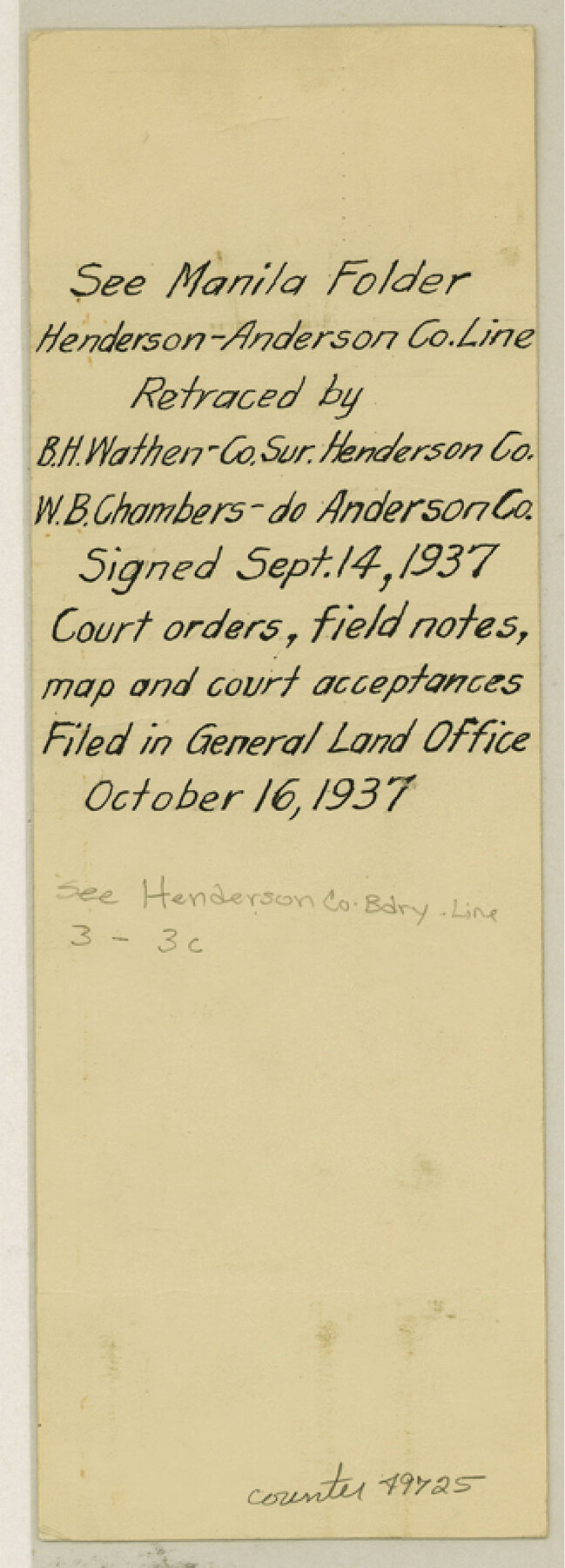
Anderson County Boundary File Index
-
Map/Doc
49725
-
Collection
General Map Collection
-
Counties
Anderson
-
Subjects
County Boundaries
-
Height x Width
9.1 x 3.3 inches
23.1 x 8.4 cm
Part of: General Map Collection
Culberson County Sketch File 10

Print $4.00
- Digital $50.00
Culberson County Sketch File 10
1911
Size 14.6 x 9.0 inches
Map/Doc 20144
Real County Working Sketch 4

Print $20.00
- Digital $50.00
Real County Working Sketch 4
1924
Size 17.1 x 15.5 inches
Map/Doc 71896
Pecos County Working Sketch 39

Print $20.00
- Digital $50.00
Pecos County Working Sketch 39
1940
Size 37.5 x 37.6 inches
Map/Doc 71511
Jeff Davis County Sketch File 47

Print $4.00
- Digital $50.00
Jeff Davis County Sketch File 47
1996
Size 4.3 x 9.7 inches
Map/Doc 28084
Fort Bend County Working Sketch 27

Print $20.00
- Digital $50.00
Fort Bend County Working Sketch 27
1982
Size 17.2 x 19.2 inches
Map/Doc 69233
Current Miscellaneous File 116

Print $8.00
- Digital $50.00
Current Miscellaneous File 116
Size 11.3 x 8.8 inches
Map/Doc 74819
Eastland County Rolled Sketch 18

Print $20.00
- Digital $50.00
Eastland County Rolled Sketch 18
Size 27.3 x 25.9 inches
Map/Doc 5776
Calhoun County Boundary File 4

Print $96.00
- Digital $50.00
Calhoun County Boundary File 4
Size 14.3 x 8.7 inches
Map/Doc 50979
Flight Mission No. DAG-19K, Frame 59, Matagorda County

Print $20.00
- Digital $50.00
Flight Mission No. DAG-19K, Frame 59, Matagorda County
1952
Size 18.6 x 22.2 inches
Map/Doc 86386
Henderson County Working Sketch 12

Print $20.00
- Digital $50.00
Henderson County Working Sketch 12
1915
Size 23.3 x 24.9 inches
Map/Doc 66145
[Location St. L. & S. W. R. R. Through Cherokee County]
![64042, [Location St. L. & S. W. R. R. Through Cherokee County], General Map Collection](https://historictexasmaps.com/wmedia_w700/maps/64042-1.tif.jpg)
Print $40.00
- Digital $50.00
[Location St. L. & S. W. R. R. Through Cherokee County]
Size 92.0 x 39.9 inches
Map/Doc 64042
Flight Mission No. DCL-7C, Frame 133, Kenedy County

Print $20.00
- Digital $50.00
Flight Mission No. DCL-7C, Frame 133, Kenedy County
1943
Size 15.4 x 15.2 inches
Map/Doc 86090
You may also like
San Patricio County Sketch File 42

Print $89.00
- Digital $50.00
San Patricio County Sketch File 42
1979
Size 11.3 x 8.8 inches
Map/Doc 36240
Zapata County

Print $40.00
- Digital $50.00
Zapata County
1935
Size 55.9 x 42.2 inches
Map/Doc 73333
Flight Mission No. CUG-3P, Frame 165, Kleberg County

Print $20.00
- Digital $50.00
Flight Mission No. CUG-3P, Frame 165, Kleberg County
1956
Size 18.5 x 22.2 inches
Map/Doc 86285
[W. E. Halsell's Subdivision of Capitol Leagues, Blocks T1,T2, T3, and S2]
![92164, [W. E. Halsell's Subdivision of Capitol Leagues, Blocks T1,T2, T3, and S2], Twichell Survey Records](https://historictexasmaps.com/wmedia_w700/maps/92164-1.tif.jpg)
Print $20.00
- Digital $50.00
[W. E. Halsell's Subdivision of Capitol Leagues, Blocks T1,T2, T3, and S2]
1907
Size 20.5 x 16.5 inches
Map/Doc 92164
Harris County Rolled Sketch 66

Print $40.00
- Digital $50.00
Harris County Rolled Sketch 66
1940
Size 36.7 x 51.4 inches
Map/Doc 9129
Presidio County Working Sketch 24

Print $20.00
- Digital $50.00
Presidio County Working Sketch 24
1945
Size 18.0 x 11.9 inches
Map/Doc 71700
Victoria County Rolled Sketch 2

Print $40.00
- Digital $50.00
Victoria County Rolled Sketch 2
1940
Size 61.1 x 18.5 inches
Map/Doc 10093
Houston County Sketch File 37

Print $6.00
- Digital $50.00
Houston County Sketch File 37
1846
Size 12.8 x 7.8 inches
Map/Doc 26819

United States - Gulf Coast - Padre I. and Laguna Madre Lat. 27° 12' to Lat. 26° 33' Texas

Print $20.00
- Digital $50.00
United States - Gulf Coast - Padre I. and Laguna Madre Lat. 27° 12' to Lat. 26° 33' Texas
1913
Size 26.9 x 18.2 inches
Map/Doc 72820
Map of El Paso County

Print $20.00
- Digital $50.00
Map of El Paso County
1888
Size 47.1 x 39.5 inches
Map/Doc 4942
Map of Refugio County

Print $40.00
- Digital $50.00
Map of Refugio County
1900
Size 35.9 x 50.4 inches
Map/Doc 16799