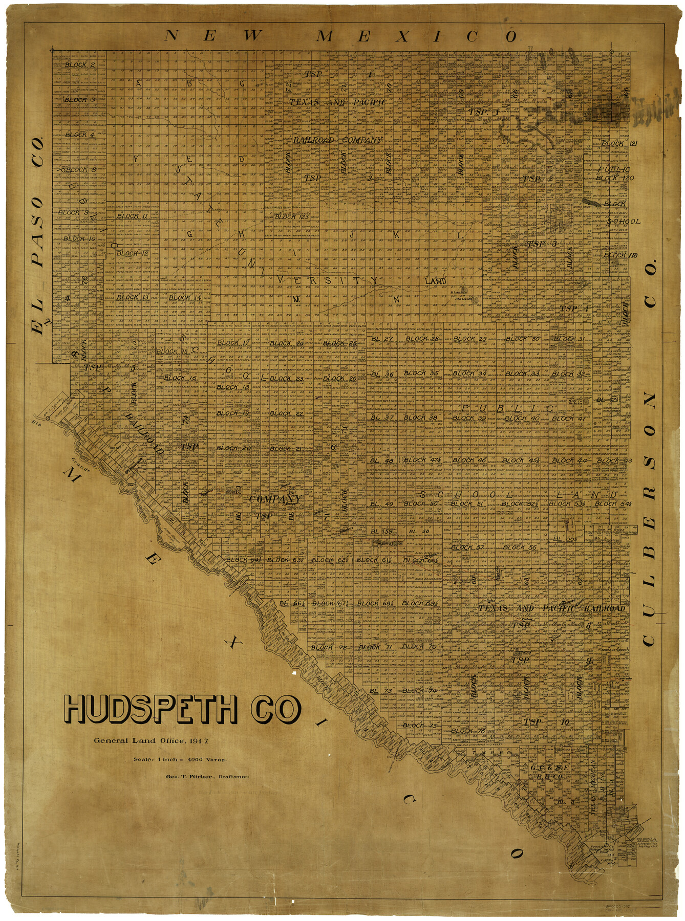
Hudspeth Co.
-
Map/Doc
4984
-
Collection
General Map Collection
-
Object Dates
1917 (Creation Date)
-
People and Organizations
Texas General Land Office (Publisher)
George T. Wicker (Compiler)
George T. Wicker (Draftsman)
-
Counties
Hudspeth
-
Subjects
County
-
Height x Width
49.9 x 37.7 inches
126.8 x 95.8 cm
Part of: General Map Collection
Johnson County Working Sketch 1

Print $20.00
- Digital $50.00
Johnson County Working Sketch 1
Size 16.3 x 21.3 inches
Map/Doc 66614
[Map of the Location Survey of the Hearne & Brazos Valley Railroad]
![64348, [Map of the Location Survey of the Hearne & Brazos Valley Railroad], General Map Collection](https://historictexasmaps.com/wmedia_w700/maps/64348.tif.jpg)
Print $40.00
- Digital $50.00
[Map of the Location Survey of the Hearne & Brazos Valley Railroad]
1891
Size 38.4 x 65.1 inches
Map/Doc 64348
Flight Mission No. DQN-5K, Frame 146, Calhoun County

Print $20.00
- Digital $50.00
Flight Mission No. DQN-5K, Frame 146, Calhoun County
1953
Size 18.6 x 22.2 inches
Map/Doc 84421
Webb County Sketch File 4-2

Print $20.00
- Digital $50.00
Webb County Sketch File 4-2
1925
Size 26.3 x 18.1 inches
Map/Doc 12615
Loving County Rolled Sketch 4

Print $40.00
- Digital $50.00
Loving County Rolled Sketch 4
1952
Size 82.2 x 19.5 inches
Map/Doc 9465
Randall County

Print $20.00
- Digital $50.00
Randall County
1917
Size 44.7 x 36.9 inches
Map/Doc 16793
Coleman County Sketch File 19

Print $4.00
- Digital $50.00
Coleman County Sketch File 19
Size 12.5 x 8.1 inches
Map/Doc 18692
Haskell County Rolled Sketch 17

Print $20.00
- Digital $50.00
Haskell County Rolled Sketch 17
2007
Size 30.0 x 36.0 inches
Map/Doc 88819
Reagan County Working Sketch 22

Print $20.00
- Digital $50.00
Reagan County Working Sketch 22
1955
Size 24.2 x 24.4 inches
Map/Doc 71864
[Galveston, Harrisburg & San Antonio Railroad from Cuero to Stockdale]
![64202, [Galveston, Harrisburg & San Antonio Railroad from Cuero to Stockdale], General Map Collection](https://historictexasmaps.com/wmedia_w700/maps/64202.tif.jpg)
Print $20.00
- Digital $50.00
[Galveston, Harrisburg & San Antonio Railroad from Cuero to Stockdale]
1907
Size 13.3 x 33.1 inches
Map/Doc 64202
Wise County Sketch File 25

Print $4.00
- Digital $50.00
Wise County Sketch File 25
1860
Size 12.5 x 8.1 inches
Map/Doc 40572
Comal County Working Sketch 10

Print $20.00
- Digital $50.00
Comal County Working Sketch 10
1974
Size 28.8 x 27.9 inches
Map/Doc 68176
You may also like
National Parks, Monuments and Shrines of the United States and Canada

National Parks, Monuments and Shrines of the United States and Canada
1958
Size 25.5 x 19.5 inches
Map/Doc 92378
Map Showing Section Lines and Corporation Lines of the City of Lubbock

Print $20.00
- Digital $50.00
Map Showing Section Lines and Corporation Lines of the City of Lubbock
1921
Size 27.5 x 25.2 inches
Map/Doc 92749
Johnson County Working Sketch 3

Print $20.00
- Digital $50.00
Johnson County Working Sketch 3
1948
Size 29.1 x 24.2 inches
Map/Doc 66616
Crosby County Sketch File 26

Print $28.00
- Digital $50.00
Crosby County Sketch File 26
1888
Size 14.1 x 8.6 inches
Map/Doc 20098
Supreme Court of the United States, October Term, 1924, No. 13, Original - The State of Oklahoma, Complainant vs. The State of Texas, Defendant, The United States, Intervener

Print $20.00
- Digital $50.00
Supreme Court of the United States, October Term, 1924, No. 13, Original - The State of Oklahoma, Complainant vs. The State of Texas, Defendant, The United States, Intervener
1924
Size 19.5 x 32.6 inches
Map/Doc 75112
Rockwall County Boundary File 4b

Print $10.00
- Digital $50.00
Rockwall County Boundary File 4b
Size 11.4 x 8.8 inches
Map/Doc 58403
[Blocks K3-K8, K11]
![90507, [Blocks K3-K8, K11], Twichell Survey Records](https://historictexasmaps.com/wmedia_w700/maps/90507-1.tif.jpg)
Print $20.00
- Digital $50.00
[Blocks K3-K8, K11]
1887
Size 13.2 x 14.6 inches
Map/Doc 90507
Chambers County Rolled Sketch CL

Print $40.00
- Digital $50.00
Chambers County Rolled Sketch CL
1909
Size 56.2 x 21.0 inches
Map/Doc 8610
Flight Mission No. CUI-1H, Frame 96, Milam County

Print $20.00
- Digital $50.00
Flight Mission No. CUI-1H, Frame 96, Milam County
1951
Size 18.7 x 22.5 inches
Map/Doc 86604
Flight Mission No. BRA-16M, Frame 91, Jefferson County

Print $20.00
- Digital $50.00
Flight Mission No. BRA-16M, Frame 91, Jefferson County
1953
Size 18.7 x 22.5 inches
Map/Doc 85703
C. C. S. D. & R. G. N. G. RR. Company, Block C2]
![90780, C. C. S. D. & R. G. N. G. RR. Company, Block C2], Twichell Survey Records](https://historictexasmaps.com/wmedia_w700/maps/90780-1.tif.jpg)
Print $20.00
- Digital $50.00
C. C. S. D. & R. G. N. G. RR. Company, Block C2]
Size 14.0 x 21.2 inches
Map/Doc 90780
Menard County Boundary File 13

Print $32.00
- Digital $50.00
Menard County Boundary File 13
Size 8.9 x 9.4 inches
Map/Doc 57121