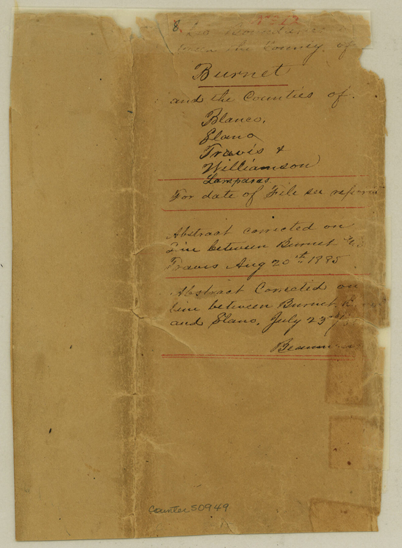
Burnet County Boundary File 12
Surveyors Report of County line between Burnet & Travis Counties
-
Map/Doc
50949
-
Collection
General Map Collection
-
Counties
Burnet
-
Subjects
County Boundaries
-
Height x Width
8.2 x 6.0 inches
20.8 x 15.2 cm
Part of: General Map Collection
Hardeman County Sketch File 13

Print $20.00
- Digital $50.00
Hardeman County Sketch File 13
Size 26.3 x 23.7 inches
Map/Doc 11625
Midland County Rolled Sketch 4A

Print $40.00
- Digital $50.00
Midland County Rolled Sketch 4A
1951
Size 43.0 x 85.3 inches
Map/Doc 61735
Lampasas County Sketch File 4

Print $4.00
- Digital $50.00
Lampasas County Sketch File 4
1861
Size 12.3 x 8.2 inches
Map/Doc 29394

[Sketch of surveys in the Bexar District along the Pedernales River]
![103, [Sketch of surveys in the Bexar District along the Pedernales River], General Map Collection](https://historictexasmaps.com/wmedia_w700/maps/103-1.tif.jpg)
Print $2.00
- Digital $50.00
[Sketch of surveys in the Bexar District along the Pedernales River]
1847
Size 13.6 x 8.3 inches
Map/Doc 103
Kleberg County Rolled Sketch 10-16

Print $20.00
- Digital $50.00
Kleberg County Rolled Sketch 10-16
1952
Size 37.0 x 33.2 inches
Map/Doc 9381
Crockett County Rolled Sketch 46C

Print $20.00
- Digital $50.00
Crockett County Rolled Sketch 46C
Size 24.5 x 23.8 inches
Map/Doc 5595
Motley County Sketch File C (N)

Print $48.00
- Digital $50.00
Motley County Sketch File C (N)
Size 7.7 x 18.4 inches
Map/Doc 31978
Fort Bend County State Real Property Sketch 8

Print $40.00
- Digital $50.00
Fort Bend County State Real Property Sketch 8
1985
Size 35.0 x 43.6 inches
Map/Doc 61682
McMullen County Working Sketch 6

Print $20.00
- Digital $50.00
McMullen County Working Sketch 6
1926
Size 24.5 x 22.9 inches
Map/Doc 70707
Garza County Rolled Sketch 11B

Print $20.00
- Digital $50.00
Garza County Rolled Sketch 11B
1915
Size 24.6 x 24.8 inches
Map/Doc 6001
Blanco County Sketch File 12

Print $20.00
- Digital $50.00
Blanco County Sketch File 12
Size 15.0 x 19.8 inches
Map/Doc 10928
You may also like
Maps of Gulf Intracoastal Waterway, Texas - Sabine River to the Rio Grande and connecting waterways including ship channels

Print $20.00
- Digital $50.00
Maps of Gulf Intracoastal Waterway, Texas - Sabine River to the Rio Grande and connecting waterways including ship channels
1966
Size 14.5 x 22.3 inches
Map/Doc 61949
Right of Way and Track Map Houston & Texas Central R.R. operated by the T. and N. O. R.R. Co., Fort Worth Branch

Print $40.00
- Digital $50.00
Right of Way and Track Map Houston & Texas Central R.R. operated by the T. and N. O. R.R. Co., Fort Worth Branch
1918
Size 31.1 x 57.4 inches
Map/Doc 64540
[Meander of Yellow House Creek from Northeast Corner of Section 37, Block S to Northeast corner of Section 3, Block O]
![91387, [Meander of Yellow House Creek from Northeast Corner of Section 37, Block S to Northeast corner of Section 3, Block O], Twichell Survey Records](https://historictexasmaps.com/wmedia_w700/maps/91387-1.tif.jpg)
Print $20.00
- Digital $50.00
[Meander of Yellow House Creek from Northeast Corner of Section 37, Block S to Northeast corner of Section 3, Block O]
Size 24.8 x 32.7 inches
Map/Doc 91387
Flight Mission No. CLL-13G, Frame 39, Willacy County

Print $20.00
- Digital $50.00
Flight Mission No. CLL-13G, Frame 39, Willacy County
1950
Size 18.4 x 18.2 inches
Map/Doc 87089
Scurry County Rolled Sketch 6

Print $20.00
- Digital $50.00
Scurry County Rolled Sketch 6
1944
Size 29.0 x 28.8 inches
Map/Doc 7766
Carson County Sketch File 1

Print $20.00
- Digital $50.00
Carson County Sketch File 1
Size 16.8 x 18.5 inches
Map/Doc 11053
Flight Mission No. DAG-21K, Frame 110, Matagorda County

Print $20.00
- Digital $50.00
Flight Mission No. DAG-21K, Frame 110, Matagorda County
1952
Size 18.6 x 22.6 inches
Map/Doc 86438
Starr County Working Sketch 14

Print $20.00
- Digital $50.00
Starr County Working Sketch 14
1952
Size 23.4 x 20.9 inches
Map/Doc 63930
Map of Terry County

Print $2.00
- Digital $50.00
Map of Terry County
Size 7.6 x 8.3 inches
Map/Doc 92888

Kimble County Working Sketch 15

Print $20.00
- Digital $50.00
Kimble County Working Sketch 15
1923
Size 22.4 x 22.1 inches
Map/Doc 70083
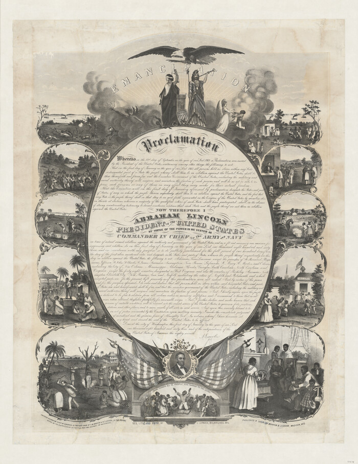
Emancipation Proclamation
Print $20.00
- Digital $50.00
Emancipation Proclamation
1864
Size 29.5 x 22.7 inches
Map/Doc 97534