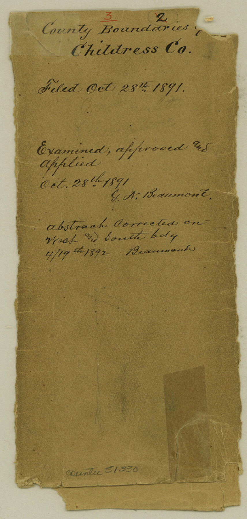
Childress County Boundary File 3
[Fieldnotes of the Boundary lines of Childress County]
-
Map/Doc
51330
-
Collection
General Map Collection
-
Counties
Childress
-
Subjects
County Boundaries
-
Height x Width
9.4 x 4.5 inches
23.9 x 11.4 cm
Part of: General Map Collection
Duval County Rolled Sketch 40

Print $20.00
- Digital $50.00
Duval County Rolled Sketch 40
1958
Size 22.8 x 31.1 inches
Map/Doc 5757
Origin of Imports and Destination of Exports at Galveston, Tex., during 1921

Print $20.00
- Digital $50.00
Origin of Imports and Destination of Exports at Galveston, Tex., during 1921
1921
Size 13.1 x 24.6 inches
Map/Doc 97169
Clay County Sketch File 26

Print $84.00
- Digital $50.00
Clay County Sketch File 26
1888
Size 14.3 x 9.0 inches
Map/Doc 18442
Real County Sketch File 3

Print $16.00
- Digital $50.00
Real County Sketch File 3
1906
Size 9.2 x 8.2 inches
Map/Doc 35039
Comanche County Sketch File 2

Print $40.00
- Digital $50.00
Comanche County Sketch File 2
1849
Size 16.0 x 12.9 inches
Map/Doc 19053
Foard County Rolled Sketch 11

Print $20.00
- Digital $50.00
Foard County Rolled Sketch 11
Size 29.2 x 35.6 inches
Map/Doc 5885
Webb County Boundary File 6

Print $123.00
- Digital $50.00
Webb County Boundary File 6
Size 14.4 x 8.8 inches
Map/Doc 59786
Duval County Boundary File 3c

Print $12.00
- Digital $50.00
Duval County Boundary File 3c
Size 11.7 x 8.4 inches
Map/Doc 52732
Sterling County Sketch File 19

Print $8.00
- Digital $50.00
Sterling County Sketch File 19
1949
Size 11.2 x 8.6 inches
Map/Doc 37169
Gregg County Rolled Sketch 9

Print $20.00
- Digital $50.00
Gregg County Rolled Sketch 9
1933
Size 38.0 x 29.8 inches
Map/Doc 6034
Flight Mission No. DIX-8P, Frame 93, Aransas County

Print $20.00
- Digital $50.00
Flight Mission No. DIX-8P, Frame 93, Aransas County
1956
Size 18.5 x 22.3 inches
Map/Doc 83918
Rockwall County Sketch File 1

Print $22.00
Rockwall County Sketch File 1
Size 14.5 x 16.1 inches
Map/Doc 35413
You may also like
Jack County Working Sketch 12

Print $20.00
- Digital $50.00
Jack County Working Sketch 12
1959
Size 18.0 x 22.4 inches
Map/Doc 66438
Red River County Working Sketch 25

Print $20.00
- Digital $50.00
Red River County Working Sketch 25
1959
Size 23.0 x 22.2 inches
Map/Doc 72008
Nueces County Rolled Sketch 116

Print $40.00
- Digital $50.00
Nueces County Rolled Sketch 116
Size 29.6 x 58.3 inches
Map/Doc 7141
![91783, [Block M-19], Twichell Survey Records](https://historictexasmaps.com/wmedia_w700/maps/91783-1.tif.jpg)
Upton County Working Sketch 59

Print $20.00
- Digital $50.00
Upton County Working Sketch 59
1987
Size 21.5 x 34.3 inches
Map/Doc 69556
Bailey County Rolled Sketch 7

Print $40.00
- Digital $50.00
Bailey County Rolled Sketch 7
1941
Size 67.7 x 44.8 inches
Map/Doc 8438
Map of Velasco

Print $20.00
- Digital $50.00
Map of Velasco
1906
Size 32.1 x 39.4 inches
Map/Doc 95357
Shores of Nueces Bay, Texas

Print $40.00
- Digital $50.00
Shores of Nueces Bay, Texas
1882
Size 33.0 x 54.3 inches
Map/Doc 73464
Hood County Working Sketch 25

Print $20.00
- Digital $50.00
Hood County Working Sketch 25
1995
Size 25.8 x 37.7 inches
Map/Doc 66219
Working Sketch in Pecos Co. [now Val Verde and Terrell Counties] / [Connecting Lines]
![91945, Working Sketch in Pecos Co. [now Val Verde and Terrell Counties] / [Connecting Lines], Twichell Survey Records](https://historictexasmaps.com/wmedia_w700/maps/91945-1.tif.jpg)
Print $20.00
- Digital $50.00
Working Sketch in Pecos Co. [now Val Verde and Terrell Counties] / [Connecting Lines]
Size 29.6 x 21.8 inches
Map/Doc 91945
Nueces County Rolled Sketch 109

Print $20.00
- Digital $50.00
Nueces County Rolled Sketch 109
1989
Size 18.8 x 25.0 inches
Map/Doc 7116
Sketch of coast of Texas, Laguna Madre from Pt. of Rocks to Corpus Christi [and accompanying letter]
![72963, Sketch of coast of Texas, Laguna Madre from Pt. of Rocks to Corpus Christi [and accompanying letter], General Map Collection](https://historictexasmaps.com/wmedia_w700/maps/72963.tif.jpg)
Print $2.00
- Digital $50.00
Sketch of coast of Texas, Laguna Madre from Pt. of Rocks to Corpus Christi [and accompanying letter]
1882
Size 11.2 x 8.8 inches
Map/Doc 72963