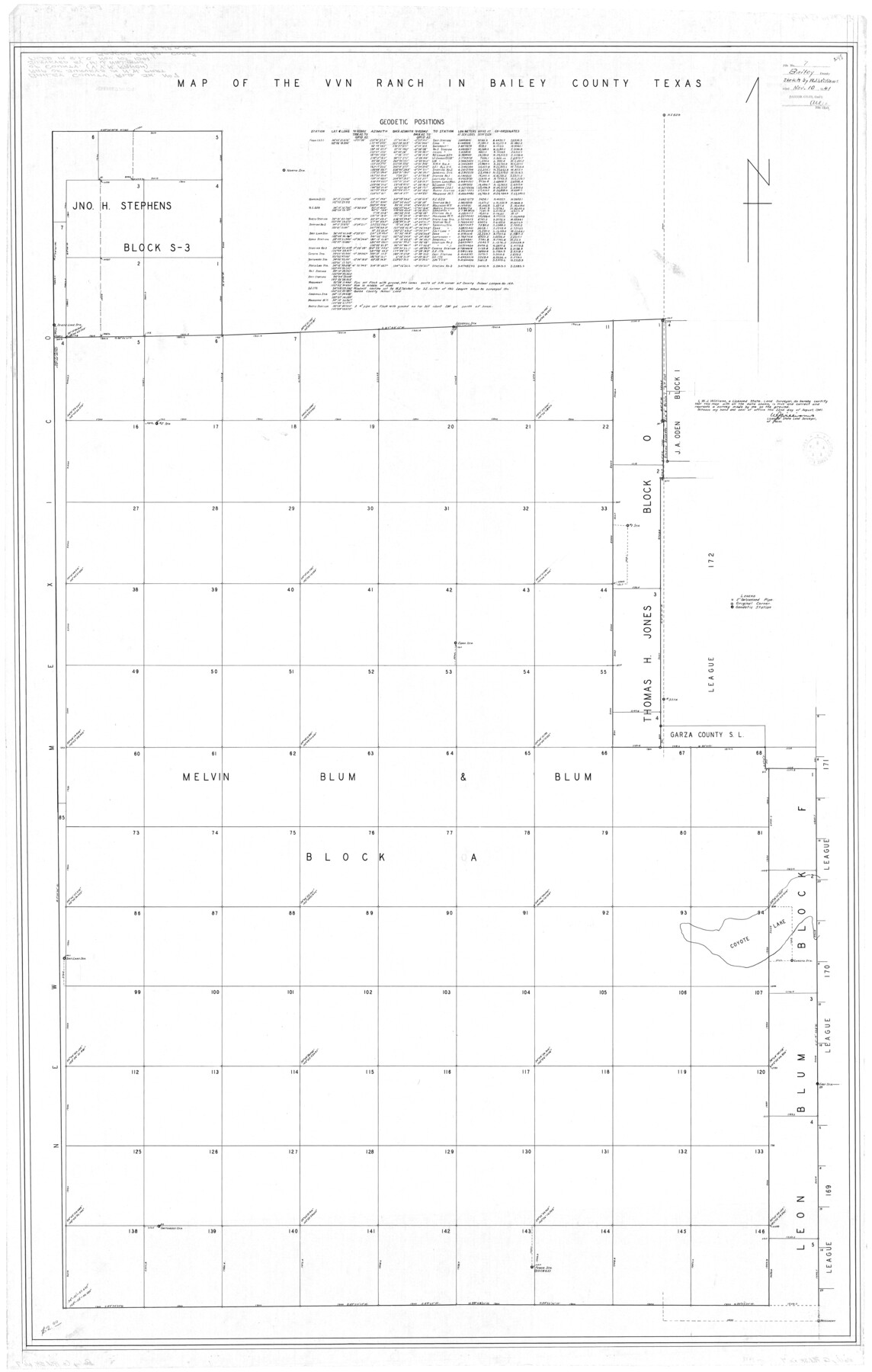
Bailey County Rolled Sketch 7
Map of the VVN Ranch in Bailey County, Texas
-
Map/Doc
8438
-
Collection
General Map Collection
-
Object Dates
8/22/1941 (Creation Date)
11/10/1941 (File Date)
-
People and Organizations
W.J. Williams (Surveyor/Engineer)
-
Counties
Bailey
-
Subjects
Surveying Rolled Sketch
-
Height x Width
67.7 x 44.8 inches
172.0 x 113.8 cm
-
Features
Coyote Lake
Part of: General Map Collection
Kerr County Rolled Sketch 10

Print $20.00
- Digital $50.00
Kerr County Rolled Sketch 10
1946
Size 20.7 x 26.2 inches
Map/Doc 6494
Hudspeth County Rolled Sketch 70

Print $40.00
- Digital $50.00
Hudspeth County Rolled Sketch 70
1982
Size 38.1 x 47.7 inches
Map/Doc 9233

Uvalde County Sketch File 23A

Print $20.00
- Digital $50.00
Uvalde County Sketch File 23A
1923
Size 18.4 x 23.0 inches
Map/Doc 12535
Potter County Working Sketch 7

Print $20.00
- Digital $50.00
Potter County Working Sketch 7
1960
Size 18.4 x 37.4 inches
Map/Doc 71667
Hansford County

Print $20.00
- Digital $50.00
Hansford County
1889
Size 22.9 x 18.5 inches
Map/Doc 3624
Atascosa County Working Sketch 34

Print $20.00
- Digital $50.00
Atascosa County Working Sketch 34
1958
Size 13.3 x 25.5 inches
Map/Doc 67230
Val Verde County Working Sketch 21

Print $20.00
- Digital $50.00
Val Verde County Working Sketch 21
1929
Size 15.2 x 30.0 inches
Map/Doc 72156
Live Oak County Working Sketch 15

Print $20.00
- Digital $50.00
Live Oak County Working Sketch 15
1952
Size 23.8 x 22.6 inches
Map/Doc 70600
[Galveston, Harrisburg & San Antonio Railroad from Cuero to Stockdale]
![64196, [Galveston, Harrisburg & San Antonio Railroad from Cuero to Stockdale], General Map Collection](https://historictexasmaps.com/wmedia_w700/maps/64196.tif.jpg)
Print $20.00
- Digital $50.00
[Galveston, Harrisburg & San Antonio Railroad from Cuero to Stockdale]
1907
Size 13.7 x 34.0 inches
Map/Doc 64196
Flight Mission No. BRE-2P, Frame 14, Nueces County

Print $20.00
- Digital $50.00
Flight Mission No. BRE-2P, Frame 14, Nueces County
1956
Size 18.5 x 22.6 inches
Map/Doc 86723
Jim Wells Co.

Print $20.00
- Digital $50.00
Jim Wells Co.
1913
Size 43.7 x 22.1 inches
Map/Doc 16861
You may also like
Maps of Gulf Intracoastal Waterway, Texas - Sabine River to the Rio Grande and connecting waterways including ship channels

Print $20.00
- Digital $50.00
Maps of Gulf Intracoastal Waterway, Texas - Sabine River to the Rio Grande and connecting waterways including ship channels
1966
Size 14.5 x 22.2 inches
Map/Doc 61974
Grayson County Working Sketch 19

Print $20.00
- Digital $50.00
Grayson County Working Sketch 19
1956
Size 40.0 x 29.0 inches
Map/Doc 63258
Guadalupe County Sketch File 23

Print $22.00
- Digital $50.00
Guadalupe County Sketch File 23
1859
Size 25.5 x 19.0 inches
Map/Doc 11592
Flight Mission No. BRA-3M, Frame 201, Jefferson County

Print $20.00
- Digital $50.00
Flight Mission No. BRA-3M, Frame 201, Jefferson County
1953
Size 18.7 x 22.5 inches
Map/Doc 85416
Brooks County Sketch File 3b

Print $12.00
- Digital $50.00
Brooks County Sketch File 3b
1939
Size 14.3 x 9.1 inches
Map/Doc 16544
Mills County Sketch File 23

Print $4.00
- Digital $50.00
Mills County Sketch File 23
Size 12.4 x 9.2 inches
Map/Doc 31672
Crockett County Working Sketch 48

Print $20.00
- Digital $50.00
Crockett County Working Sketch 48
1938
Size 23.8 x 13.2 inches
Map/Doc 68381
Flight Mission No. CRC-4R, Frame 174, Chambers County

Print $20.00
- Digital $50.00
Flight Mission No. CRC-4R, Frame 174, Chambers County
1956
Size 18.6 x 22.3 inches
Map/Doc 84925
Galveston County NRC Article 33.136 Sketch 13

Print $20.00
- Digital $50.00
Galveston County NRC Article 33.136 Sketch 13
2002
Size 17.9 x 22.4 inches
Map/Doc 77044
Flight Mission No. DCL-6C, Frame 27, Kenedy County

Print $20.00
- Digital $50.00
Flight Mission No. DCL-6C, Frame 27, Kenedy County
1943
Size 18.7 x 22.4 inches
Map/Doc 85884
Palo Pinto County

Print $20.00
- Digital $50.00
Palo Pinto County
Size 23.7 x 18.6 inches
Map/Doc 3936
Coleman County

Print $40.00
- Digital $50.00
Coleman County
1897
Size 49.4 x 34.9 inches
Map/Doc 66758