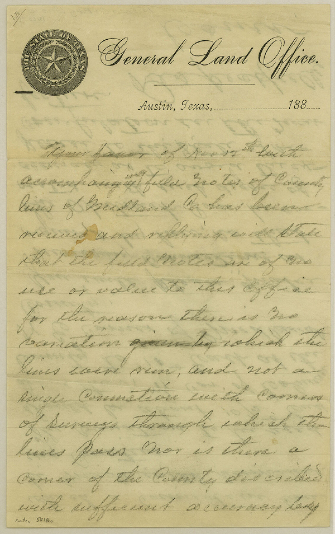
Midland County Boundary File 1a
[Statement of GLO Commissioner regarding Midland County Boundaries]
-
Map/Doc
57160
-
Collection
General Map Collection
-
Counties
Midland
-
Subjects
County Boundaries
-
Height x Width
9.5 x 6.0 inches
24.1 x 15.2 cm
Part of: General Map Collection
Harrison County Sketch File 16

Print $20.00
- Digital $50.00
Harrison County Sketch File 16
1910
Size 41.7 x 27.5 inches
Map/Doc 10488
Lamb County Working Sketch 1

Print $20.00
- Digital $50.00
Lamb County Working Sketch 1
1917
Size 40.2 x 43.4 inches
Map/Doc 70274

Galveston County Rolled Sketch DB

Print $20.00
- Digital $50.00
Galveston County Rolled Sketch DB
Size 37.0 x 47.5 inches
Map/Doc 9854
Brewster County Working Sketch 87

Print $40.00
- Digital $50.00
Brewster County Working Sketch 87
1973
Size 37.4 x 56.6 inches
Map/Doc 67687
Polk County Working Sketch 19

Print $20.00
- Digital $50.00
Polk County Working Sketch 19
1950
Size 34.0 x 26.5 inches
Map/Doc 71634
Hardin County Sketch File 12

Print $4.00
- Digital $50.00
Hardin County Sketch File 12
Size 5.4 x 8.2 inches
Map/Doc 25116
Tarrant County Working Sketch 18

Print $20.00
- Digital $50.00
Tarrant County Working Sketch 18
1996
Size 20.4 x 18.5 inches
Map/Doc 62435
Flight Mission No. DQN-1K, Frame 144, Calhoun County

Print $20.00
- Digital $50.00
Flight Mission No. DQN-1K, Frame 144, Calhoun County
1953
Size 18.5 x 22.2 inches
Map/Doc 84207
Map of Jack County

Print $20.00
- Digital $50.00
Map of Jack County
1882
Size 21.6 x 24.5 inches
Map/Doc 3706
Polk County Rolled Sketch 31

Print $20.00
- Digital $50.00
Polk County Rolled Sketch 31
Size 24.5 x 21.1 inches
Map/Doc 7317
Intracoastal Waterway in Texas - Corpus Christi to Point Isabel including Arroyo Colorado to Mo. Pac. R.R. Bridge Near Harlingen

Print $20.00
- Digital $50.00
Intracoastal Waterway in Texas - Corpus Christi to Point Isabel including Arroyo Colorado to Mo. Pac. R.R. Bridge Near Harlingen
1933
Size 28.2 x 40.8 inches
Map/Doc 61852
You may also like

Bailey County Sketch File 5

Print $40.00
- Digital $50.00
Bailey County Sketch File 5
1907
Size 31.9 x 22.8 inches
Map/Doc 10883
Atascosa County Sketch File 2b

Print $6.00
- Digital $50.00
Atascosa County Sketch File 2b
1855
Size 8.8 x 13.2 inches
Map/Doc 13728
Montgomery County Rolled Sketch 26A

Print $20.00
- Digital $50.00
Montgomery County Rolled Sketch 26A
1941
Size 29.1 x 38.8 inches
Map/Doc 6809
San Patricio County Rolled Sketch 37

Print $127.00
- Digital $50.00
San Patricio County Rolled Sketch 37
Size 10.3 x 15.2 inches
Map/Doc 48888
Flight Mission No. BRA-7M, Frame 38, Jefferson County

Print $20.00
- Digital $50.00
Flight Mission No. BRA-7M, Frame 38, Jefferson County
1953
Size 18.6 x 22.4 inches
Map/Doc 85489
Red River County Working Sketch 69

Print $20.00
- Digital $50.00
Red River County Working Sketch 69
1975
Size 23.7 x 19.1 inches
Map/Doc 72052
Upton County Sketch File 1

Print $40.00
- Digital $50.00
Upton County Sketch File 1
1881
Size 24.1 x 65.4 inches
Map/Doc 10412
Harrison County

Print $20.00
- Digital $50.00
Harrison County
1920
Size 45.1 x 41.8 inches
Map/Doc 1850
General Highway Map. Detail of Cities and Towns in Tarrant County, Texas. City Map, Fort Worth and vicinity, Tarrant County, Texas

Print $20.00
General Highway Map. Detail of Cities and Towns in Tarrant County, Texas. City Map, Fort Worth and vicinity, Tarrant County, Texas
1961
Size 18.1 x 24.9 inches
Map/Doc 79668
Lakeview Addition to the City of Shallowater out of the Southeast 1/4 of Section 27, Block D5

Print $3.00
- Digital $50.00
Lakeview Addition to the City of Shallowater out of the Southeast 1/4 of Section 27, Block D5
1955
Size 17.9 x 11.6 inches
Map/Doc 92870
Flight Mission No. CRC-3R, Frame 38, Chambers County

Print $20.00
- Digital $50.00
Flight Mission No. CRC-3R, Frame 38, Chambers County
1956
Size 18.7 x 22.4 inches
Map/Doc 84811