Mitchell County Boundary File 3
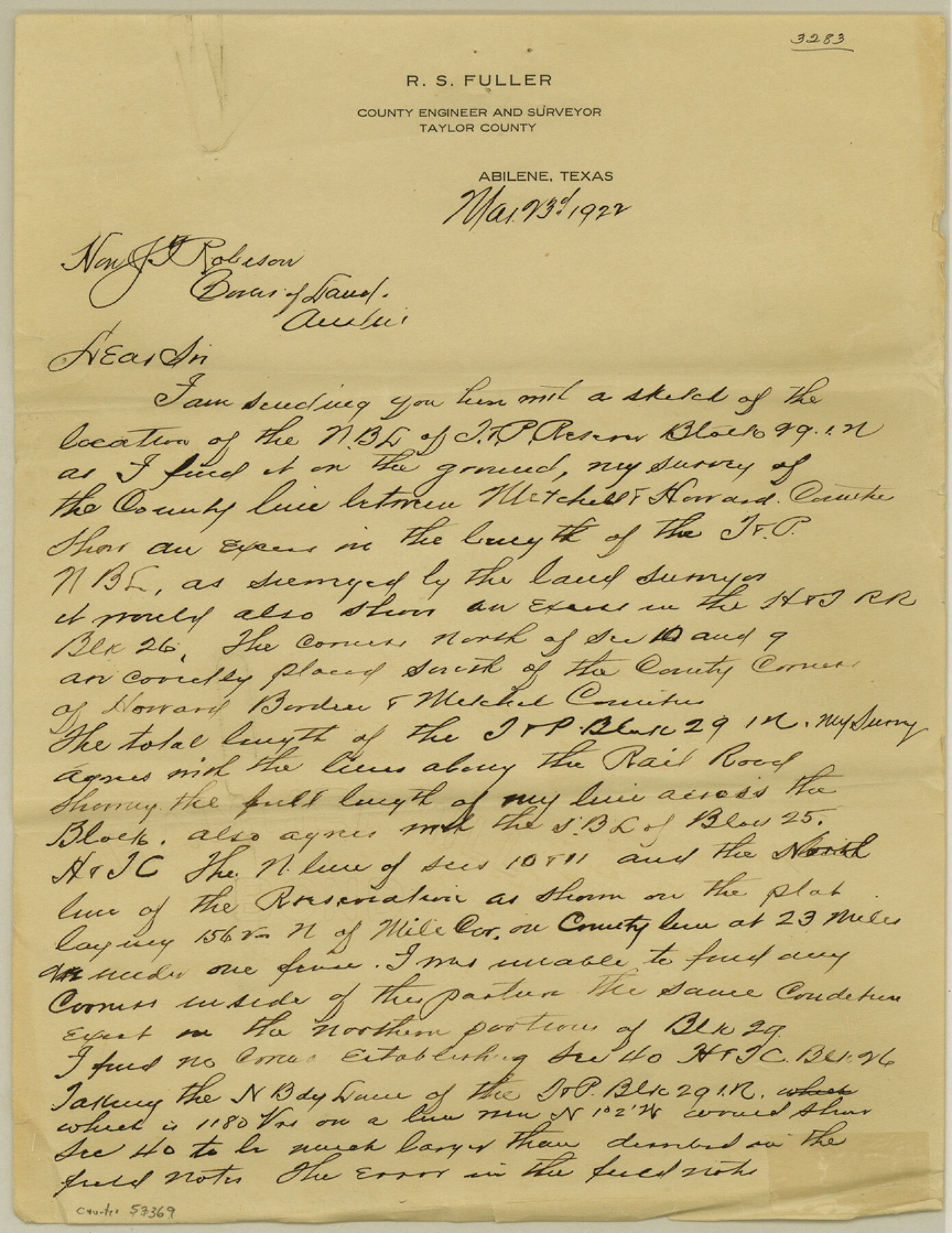
[Letter regarding the county line between Mitchell & Howard Counties]
-
Map/Doc
57369
-
Collection
General Map Collection
-
Counties
Mitchell
-
Subjects
County Boundaries
-
Height x Width
11.2 x 8.6 inches
28.5 x 21.8 cm
Part of: General Map Collection
Stonewall County Working Sketch 13

Print $20.00
- Digital $50.00
Stonewall County Working Sketch 13
1951
Size 31.9 x 33.7 inches
Map/Doc 62320
Blanco County Sketch File 32

Print $4.00
- Digital $50.00
Blanco County Sketch File 32
1888
Size 8.5 x 11.1 inches
Map/Doc 14633
Old Miscellaneous File 27a

Print $142.00
- Digital $50.00
Old Miscellaneous File 27a
Size 14.2 x 8.8 inches
Map/Doc 75651

Flight Mission No. DQO-2K, Frame 165, Galveston County

Print $20.00
- Digital $50.00
Flight Mission No. DQO-2K, Frame 165, Galveston County
1952
Size 18.9 x 22.4 inches
Map/Doc 85054
Haskell County Rolled Sketch 14

Print $3.00
- Digital $50.00
Haskell County Rolled Sketch 14
1991
Size 11.1 x 17.1 inches
Map/Doc 6172
Pecos County Rolled Sketch 184

Print $20.00
- Digital $50.00
Pecos County Rolled Sketch 184
1977
Size 44.4 x 30.0 inches
Map/Doc 7303
Eastland County Sketch File 15

Print $2.00
- Digital $50.00
Eastland County Sketch File 15
1882
Size 11.4 x 8.6 inches
Map/Doc 21599
Jackson County Sketch File 13

Print $40.00
- Digital $50.00
Jackson County Sketch File 13
Size 29.0 x 18.6 inches
Map/Doc 11839
Harris County Sketch File 35

Print $4.00
- Digital $50.00
Harris County Sketch File 35
1840
Size 14.1 x 9.0 inches
Map/Doc 25438
Hale County Boundary File 1

Print $44.00
- Digital $50.00
Hale County Boundary File 1
Size 10.0 x 30.9 inches
Map/Doc 54031
Bexar County Sketch File 42a

Print $4.00
- Digital $50.00
Bexar County Sketch File 42a
Size 8.0 x 9.6 inches
Map/Doc 14520
You may also like
The Judicial District/County of Pashcal. Created, January 28, 1841

Print $20.00
The Judicial District/County of Pashcal. Created, January 28, 1841
2020
Size 15.0 x 21.7 inches
Map/Doc 96343

Aransas County Working Sketch 19

Print $20.00
- Digital $50.00
Aransas County Working Sketch 19
1978
Size 25.1 x 31.1 inches
Map/Doc 67186
Howard County Sketch File 4

Print $20.00
- Digital $50.00
Howard County Sketch File 4
Size 25.6 x 21.8 inches
Map/Doc 11793
Map of Robertson Co.

Print $20.00
- Digital $50.00
Map of Robertson Co.
1889
Size 44.0 x 39.1 inches
Map/Doc 3996
Nueces River, Calallen Sheet

Print $20.00
- Digital $50.00
Nueces River, Calallen Sheet
1927
Size 32.7 x 37.3 inches
Map/Doc 65087
The Chief Justice County of Gonzales. Lands in Conflict with Victoria County

Print $20.00
The Chief Justice County of Gonzales. Lands in Conflict with Victoria County
2020
Size 22.3 x 21.7 inches
Map/Doc 96048
Tarrant County Sketch File 11

Print $11.00
- Digital $50.00
Tarrant County Sketch File 11
1859
Size 7.5 x 6.2 inches
Map/Doc 37698
Current Miscellaneous File 86

Print $6.00
- Digital $50.00
Current Miscellaneous File 86
Size 11.2 x 8.8 inches
Map/Doc 74240
Carta Geografica Della Florida Nell America Settentrionale

Print $20.00
- Digital $50.00
Carta Geografica Della Florida Nell America Settentrionale
1740
Size 14.1 x 18.5 inches
Map/Doc 89222
Flight Mission No. CUI-1H, Frame 96, Milam County

Print $20.00
- Digital $50.00
Flight Mission No. CUI-1H, Frame 96, Milam County
1951
Size 18.7 x 22.5 inches
Map/Doc 86604
Flight Mission No. CUG-3P, Frame 17, Kleberg County

Print $20.00
- Digital $50.00
Flight Mission No. CUG-3P, Frame 17, Kleberg County
1956
Size 18.6 x 22.3 inches
Map/Doc 86227