Duval County Rolled Sketch 42
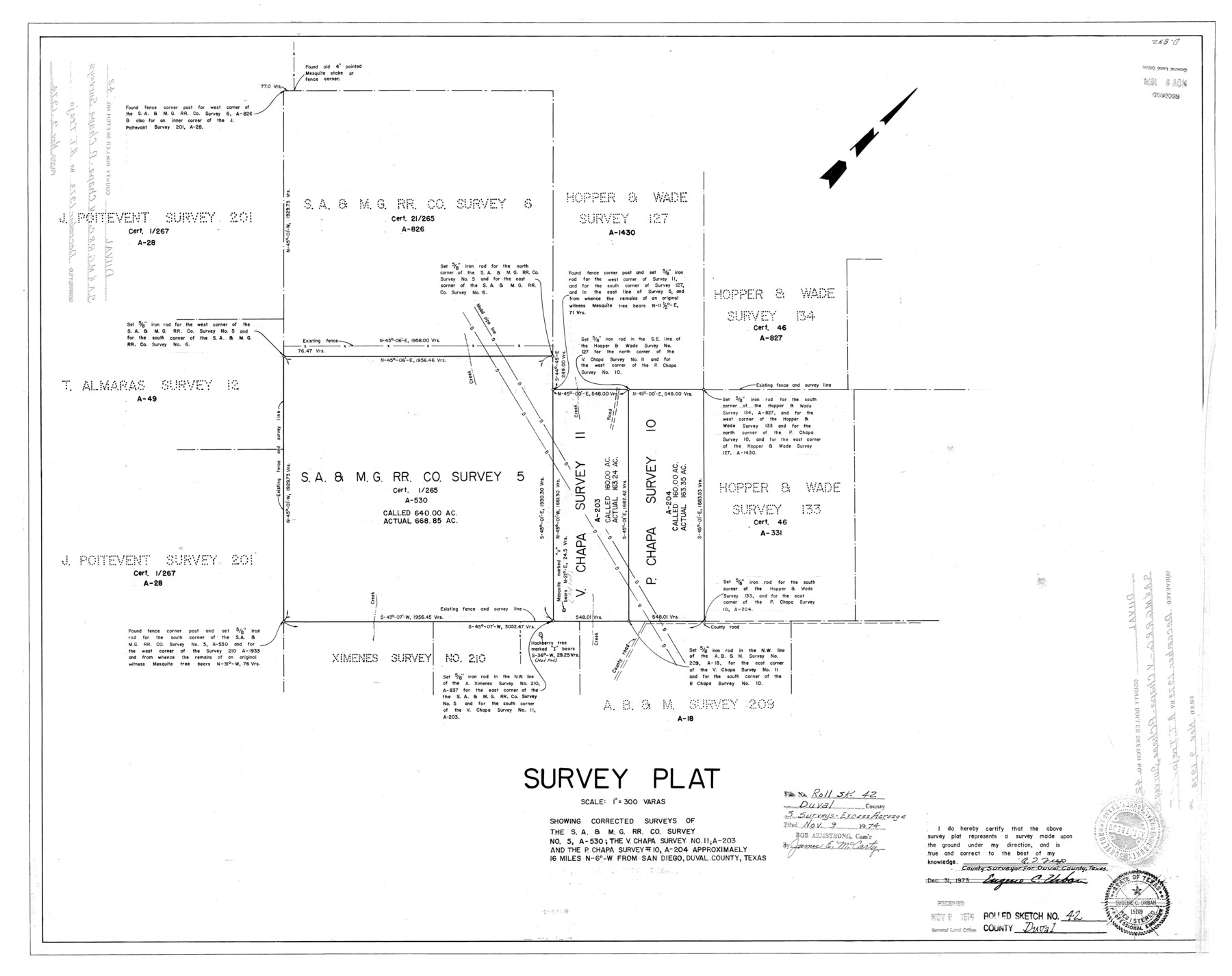
Survey plat showing corrected sureys of the S. A. & M. G. RR. Co. survey no. 5, A-530; the V. Chapa survey no. 11, A-203 and the P. Chapa survey 10, A-204
-
Map/Doc
5759
-
Collection
General Map Collection
-
Object Dates
1973 (Creation Date)
1974/11/9 (File Date)
-
People and Organizations
A.T. Trejo (Surveyor/Engineer)
-
Counties
Duval
-
Subjects
Surveying Rolled Sketch
-
Height x Width
23.6 x 29.8 inches
59.9 x 75.7 cm
-
Scale
1" = 300 varas
Part of: General Map Collection
Lynn County Working Sketch 2

Print $20.00
- Digital $50.00
Lynn County Working Sketch 2
1951
Size 19.8 x 42.5 inches
Map/Doc 70672
Flight Mission No. DIX-10P, Frame 73, Aransas County

Print $20.00
- Digital $50.00
Flight Mission No. DIX-10P, Frame 73, Aransas County
1956
Size 18.7 x 22.4 inches
Map/Doc 83934
Brewster County Rolled Sketch 80

Print $40.00
- Digital $50.00
Brewster County Rolled Sketch 80
1943
Size 51.6 x 42.7 inches
Map/Doc 8493
Topographical Map of the Rio Grande, Sheet No. 25

Print $20.00
- Digital $50.00
Topographical Map of the Rio Grande, Sheet No. 25
1912
Map/Doc 89549
Flight Mission No. DCL-7C, Frame 31, Kenedy County

Print $20.00
- Digital $50.00
Flight Mission No. DCL-7C, Frame 31, Kenedy County
1943
Size 15.4 x 15.2 inches
Map/Doc 86023
Hutchinson County Rolled Sketch 44-8

Print $20.00
- Digital $50.00
Hutchinson County Rolled Sketch 44-8
2002
Size 24.0 x 36.0 inches
Map/Doc 77544
Fisher County Rolled Sketch 3

Print $20.00
- Digital $50.00
Fisher County Rolled Sketch 3
Size 40.5 x 38.6 inches
Map/Doc 8887
Throckmorton County Rolled Sketch 1

Print $20.00
- Digital $50.00
Throckmorton County Rolled Sketch 1
1927
Size 23.5 x 30.3 inches
Map/Doc 7984
Blanco County Sketch File 8

Print $4.00
- Digital $50.00
Blanco County Sketch File 8
Size 8.1 x 12.8 inches
Map/Doc 14584
Taylor County Rolled Sketch 25

Print $20.00
- Digital $50.00
Taylor County Rolled Sketch 25
1962
Size 27.1 x 46.0 inches
Map/Doc 7917
Hays County Sketch File 2

Print $4.00
- Digital $50.00
Hays County Sketch File 2
1846
Size 6.3 x 8.1 inches
Map/Doc 26200
Liberty County Working Sketch 41

Print $20.00
- Digital $50.00
Liberty County Working Sketch 41
1953
Size 21.4 x 20.8 inches
Map/Doc 70500
You may also like
Haskell County

Print $20.00
- Digital $50.00
Haskell County
1933
Size 45.8 x 39.4 inches
Map/Doc 1852
Nacogdoches County Working Sketch 11

Print $20.00
- Digital $50.00
Nacogdoches County Working Sketch 11
1985
Size 41.1 x 28.0 inches
Map/Doc 71227
Taylor County Rolled Sketch 27

Print $20.00
- Digital $50.00
Taylor County Rolled Sketch 27
Size 37.5 x 30.3 inches
Map/Doc 7918
Right of Way & Track Map San Antonio & Aransas Pass Railway Co.

Print $40.00
- Digital $50.00
Right of Way & Track Map San Antonio & Aransas Pass Railway Co.
1919
Size 25.7 x 56.7 inches
Map/Doc 64039
[Block Y, Walker County School Land, and vicinity]
![92536, [Block Y, Walker County School Land, and vicinity], Twichell Survey Records](https://historictexasmaps.com/wmedia_w700/maps/92536-1.tif.jpg)
Print $20.00
- Digital $50.00
[Block Y, Walker County School Land, and vicinity]
Size 23.3 x 24.8 inches
Map/Doc 92536
Flight Mission No. BRE-2P, Frame 102, Nueces County

Print $20.00
- Digital $50.00
Flight Mission No. BRE-2P, Frame 102, Nueces County
1956
Size 18.4 x 22.2 inches
Map/Doc 86787
Map of Bailey County, Texas

Print $20.00
- Digital $50.00
Map of Bailey County, Texas
1912
Size 15.8 x 19.8 inches
Map/Doc 90248
Bandera County Boundary File 4a

Print $32.00
- Digital $50.00
Bandera County Boundary File 4a
Size 13.3 x 8.7 inches
Map/Doc 50276
Cass County Working Sketch 14

Print $20.00
- Digital $50.00
Cass County Working Sketch 14
1956
Size 36.7 x 26.4 inches
Map/Doc 67917
Newton County Working Sketch 3

Print $20.00
- Digital $50.00
Newton County Working Sketch 3
1924
Size 18.2 x 20.6 inches
Map/Doc 71249
Flight Mission No. CGI-1N, Frame 220, Cameron County

Print $20.00
- Digital $50.00
Flight Mission No. CGI-1N, Frame 220, Cameron County
1955
Size 18.5 x 22.1 inches
Map/Doc 84529
Trinity River, Malloy Bridge Sheet

Print $20.00
- Digital $50.00
Trinity River, Malloy Bridge Sheet
1922
Size 41.7 x 40.2 inches
Map/Doc 65189