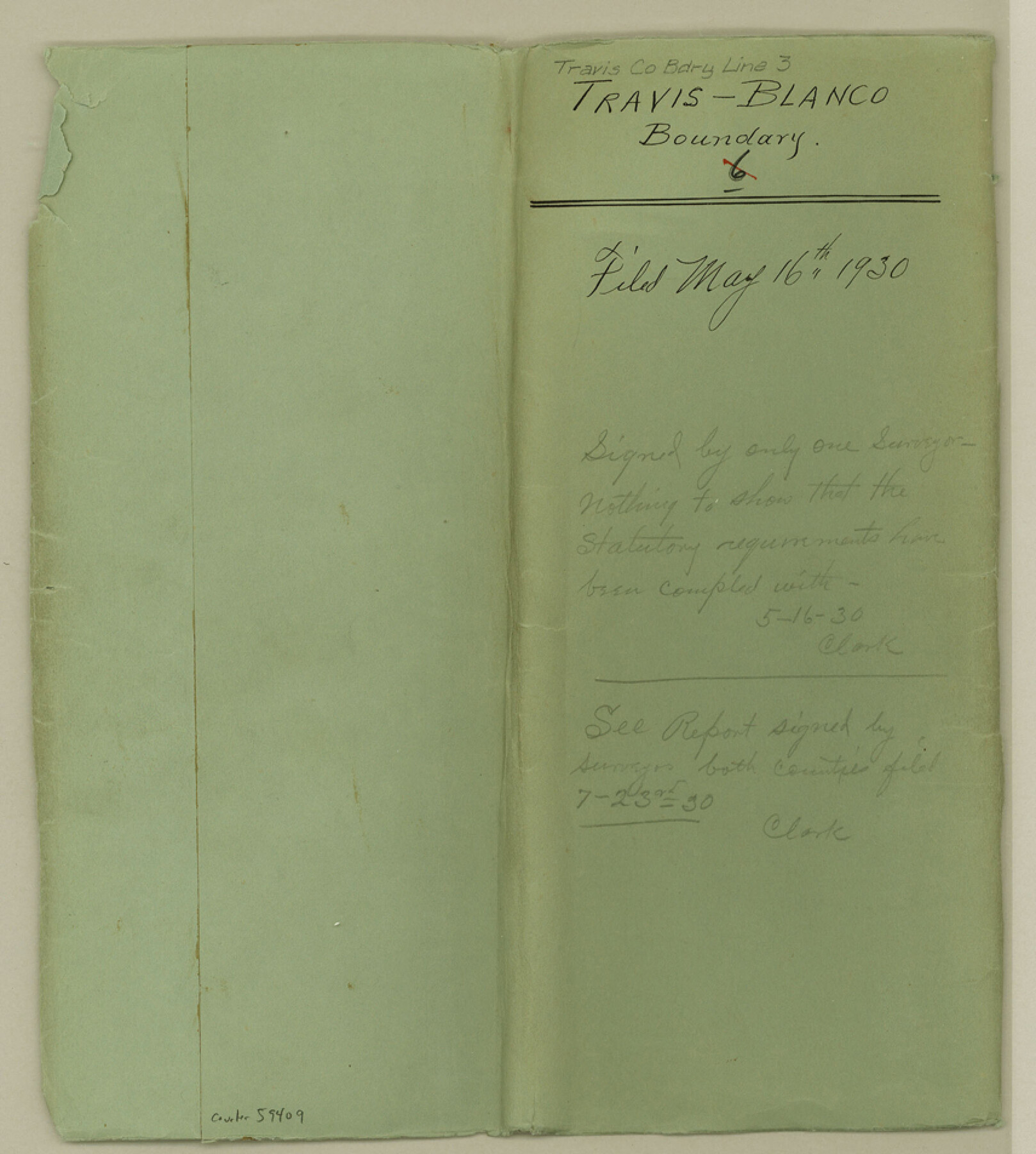
Travis County Boundary File 3
Map showing resurvey of the Travis-Blanco County Line from SE corner of Burnet County to NW corner of Hays County
-
Map/Doc
59409
-
Collection
General Map Collection
-
Counties
Travis
-
Subjects
County Boundaries
-
Height x Width
9.5 x 8.6 inches
24.1 x 21.8 cm
Part of: General Map Collection
Harris County Boundary File 2

Print $8.00
- Digital $50.00
Harris County Boundary File 2
Size 8.1 x 8.7 inches
Map/Doc 54294
Montague County Rolled Sketch 3

Print $20.00
- Digital $50.00
Montague County Rolled Sketch 3
1940
Size 24.0 x 15.9 inches
Map/Doc 6787
Plat showing surveys made for N. Vasquez, Sr. of Casa Piedra, Texas in Block 312, T. C. Ry. Co.

Print $20.00
- Digital $50.00
Plat showing surveys made for N. Vasquez, Sr. of Casa Piedra, Texas in Block 312, T. C. Ry. Co.
1947
Size 16.5 x 22.3 inches
Map/Doc 2062
San Saba County Sketch File 7a

Print $6.00
- Digital $50.00
San Saba County Sketch File 7a
1883
Size 16.4 x 10.5 inches
Map/Doc 36428
Pecos County Sketch File 68

Print $6.00
- Digital $50.00
Pecos County Sketch File 68
1920
Size 14.4 x 8.8 inches
Map/Doc 33866
Pecos County Working Sketch 54
Print $20.00
- Digital $50.00
Pecos County Working Sketch 54
1948
Size 26.0 x 24.1 inches
Map/Doc 71526
Leon County Rolled Sketch 15

Print $20.00
- Digital $50.00
Leon County Rolled Sketch 15
1979
Size 23.5 x 18.9 inches
Map/Doc 6601
Lipscomb County Boundary File 16

Print $2.00
- Digital $50.00
Lipscomb County Boundary File 16
Size 11.5 x 7.1 inches
Map/Doc 56386
Duval County Boundary File 3l

Print $40.00
- Digital $50.00
Duval County Boundary File 3l
Size 13.4 x 17.1 inches
Map/Doc 52761
Sutton County Boundary File 2

Print $22.00
- Digital $50.00
Sutton County Boundary File 2
Size 14.4 x 8.9 inches
Map/Doc 59004
Gaines County Working Sketch 28

Print $20.00
- Digital $50.00
Gaines County Working Sketch 28
1982
Size 20.9 x 24.6 inches
Map/Doc 69328
Jeff Davis County Sketch File 45

Print $10.00
- Digital $50.00
Jeff Davis County Sketch File 45
1890
Size 14.0 x 8.5 inches
Map/Doc 28075
You may also like
Flight Mission No. BRA-7M, Frame 40, Jefferson County

Print $20.00
- Digital $50.00
Flight Mission No. BRA-7M, Frame 40, Jefferson County
1953
Size 18.7 x 22.3 inches
Map/Doc 85491
The Republic County of Fort Bend. January 28, 1841

Print $20.00
The Republic County of Fort Bend. January 28, 1841
2020
Size 14.7 x 21.6 inches
Map/Doc 96140
Foard County Sketch File 8

Print $6.00
- Digital $50.00
Foard County Sketch File 8
Size 10.5 x 11.8 inches
Map/Doc 22810
[Texas Boundary Line]
![92081, [Texas Boundary Line], Twichell Survey Records](https://historictexasmaps.com/wmedia_w700/maps/92081-1.tif.jpg)
Print $20.00
- Digital $50.00
[Texas Boundary Line]
Size 21.2 x 12.4 inches
Map/Doc 92081
Dickens County Sketch File G

Print $8.00
- Digital $50.00
Dickens County Sketch File G
Size 12.0 x 8.7 inches
Map/Doc 20854
Treaty to Resolve Pending Boundary Differences and Maintain the Rio Grande and Colorado River as the International Boundary Between the United States of American and Mexico

Print $20.00
- Digital $50.00
Treaty to Resolve Pending Boundary Differences and Maintain the Rio Grande and Colorado River as the International Boundary Between the United States of American and Mexico
1970
Size 10.8 x 29.8 inches
Map/Doc 83106
Denton County Sketch File 1

Print $2.00
- Digital $50.00
Denton County Sketch File 1
Size 8.4 x 10.6 inches
Map/Doc 20681
Cameron County Rolled Sketch 20C

Print $20.00
- Digital $50.00
Cameron County Rolled Sketch 20C
Size 13.1 x 11.9 inches
Map/Doc 5475
Surveys in the Milam District at the fork of the Yegua and Brazos Rivers and on the Leon River

Print $2.00
- Digital $50.00
Surveys in the Milam District at the fork of the Yegua and Brazos Rivers and on the Leon River
1846
Size 9.2 x 16.0 inches
Map/Doc 254
San Jacinto County Sketch File A

Print $5.00
San Jacinto County Sketch File A
1895
Size 8.5 x 11.3 inches
Map/Doc 35716
Flight Mission No. CUG-1P, Frame 165, Kleberg County

Print $20.00
- Digital $50.00
Flight Mission No. CUG-1P, Frame 165, Kleberg County
1956
Size 18.7 x 22.2 inches
Map/Doc 86172
Burnet County Sketch File 11

Print $40.00
- Digital $50.00
Burnet County Sketch File 11
1848
Size 12.8 x 15.2 inches
Map/Doc 16692