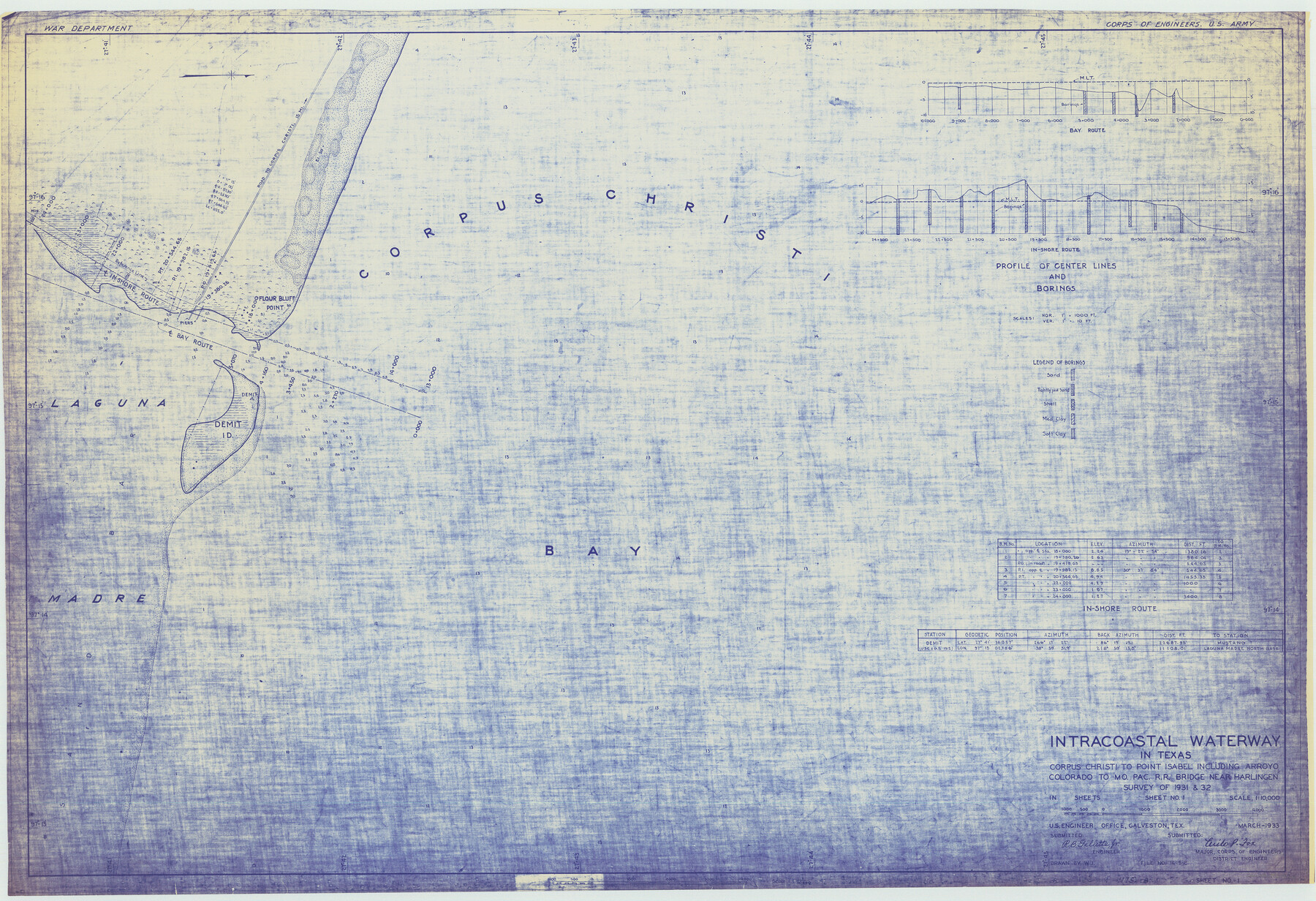
Intracoastal Waterway in Texas - Corpus Christi to Point Isabel including Arroyo Colorado to Mo. Pac. R.R. Bridge Near Harlingen
-
Map/Doc
61844
-
Collection
General Map Collection
-
Object Dates
1933 (Creation Date)
-
Subjects
Intracoastal Waterways
-
Height x Width
28.1 x 41.0 inches
71.4 x 104.1 cm
Part of: General Map Collection
Atascosa County Sketch File 12

Print $4.00
- Digital $50.00
Atascosa County Sketch File 12
1862
Size 14.4 x 8.3 inches
Map/Doc 13769
Sterling County Rolled Sketch 32

Print $20.00
- Digital $50.00
Sterling County Rolled Sketch 32
Size 17.9 x 29.4 inches
Map/Doc 7856
Duval County Working Sketch 29

Print $20.00
- Digital $50.00
Duval County Working Sketch 29
1948
Size 28.9 x 31.5 inches
Map/Doc 68753
Bee County Sketch File 29

Print $6.00
- Digital $50.00
Bee County Sketch File 29
1887
Size 14.0 x 8.8 inches
Map/Doc 14338
Il Cuscho Citta Principale Della Provincia del Peru

Print $20.00
- Digital $50.00
Il Cuscho Citta Principale Della Provincia del Peru
1592
Size 12.3 x 15.4 inches
Map/Doc 97026
Wharton County Sketch File 3

Print $4.00
- Digital $50.00
Wharton County Sketch File 3
1875
Size 9.1 x 8.3 inches
Map/Doc 39915
Map of Kerr County

Print $20.00
- Digital $50.00
Map of Kerr County
1864
Size 14.8 x 17.9 inches
Map/Doc 3760
Cameron County Aerial Photograph Index Sheet 3

Print $20.00
- Digital $50.00
Cameron County Aerial Photograph Index Sheet 3
1955
Size 21.1 x 17.4 inches
Map/Doc 83675
Burnet County Working Sketch 2

Print $20.00
- Digital $50.00
Burnet County Working Sketch 2
1953
Size 18.3 x 29.1 inches
Map/Doc 67845
Hopkins County Sketch File 11

Print $4.00
- Digital $50.00
Hopkins County Sketch File 11
Size 7.7 x 7.7 inches
Map/Doc 26704
Jeff Davis County Rolled Sketch 1

Print $20.00
- Digital $50.00
Jeff Davis County Rolled Sketch 1
1882
Size 23.0 x 43.2 inches
Map/Doc 6359
Harrison County Rolled Sketch 8

Print $33.00
- Digital $50.00
Harrison County Rolled Sketch 8
Size 10.1 x 15.2 inches
Map/Doc 45825
You may also like
Donley County Working Sketch 8

Print $20.00
- Digital $50.00
Donley County Working Sketch 8
1981
Size 36.9 x 46.8 inches
Map/Doc 68741
Refugio County Sketch File 2

Print $6.00
- Digital $50.00
Refugio County Sketch File 2
1846
Size 12.6 x 7.7 inches
Map/Doc 35238
Williamson County

Print $40.00
- Digital $50.00
Williamson County
1946
Size 37.3 x 54.8 inches
Map/Doc 77460
Intracoastal Waterway in Texas - Corpus Christi to Point Isabel including Arroyo Colorado to Mo. Pac. R.R. Bridge Near Harlingen

Print $20.00
- Digital $50.00
Intracoastal Waterway in Texas - Corpus Christi to Point Isabel including Arroyo Colorado to Mo. Pac. R.R. Bridge Near Harlingen
1933
Size 27.7 x 41.0 inches
Map/Doc 61857
[Block XR, Capitol Leagues 161, 162, 164, 174, 178, 179, and 180]
![90729, [Block XR, Capitol Leagues 161, 162, 164, 174, 178, 179, and 180], Twichell Survey Records](https://historictexasmaps.com/wmedia_w700/maps/90729-1.tif.jpg)
Print $20.00
- Digital $50.00
[Block XR, Capitol Leagues 161, 162, 164, 174, 178, 179, and 180]
1908
Size 13.1 x 21.6 inches
Map/Doc 90729
Clay County Sketch File 12

Print $4.00
- Digital $50.00
Clay County Sketch File 12
1873
Size 13.0 x 8.2 inches
Map/Doc 18411
Maps of Gulf Intracoastal Waterway, Texas - Sabine River to the Rio Grande and connecting waterways including ship channels

Print $20.00
- Digital $50.00
Maps of Gulf Intracoastal Waterway, Texas - Sabine River to the Rio Grande and connecting waterways including ship channels
1966
Size 14.5 x 22.2 inches
Map/Doc 61964
Preliminary Chart of Galveston Bay, Texas

Print $20.00
- Digital $50.00
Preliminary Chart of Galveston Bay, Texas
1855
Size 22.5 x 18.4 inches
Map/Doc 69867
Orange County Sketch File 13

Print $6.00
- Digital $50.00
Orange County Sketch File 13
1885
Size 11.3 x 9.7 inches
Map/Doc 33326
Yellow House Ranch Lamb County, Texas

Print $20.00
- Digital $50.00
Yellow House Ranch Lamb County, Texas
Size 24.0 x 26.2 inches
Map/Doc 92178
Lipscomb County Working Sketch 5

Print $20.00
- Digital $50.00
Lipscomb County Working Sketch 5
1977
Size 26.8 x 30.0 inches
Map/Doc 70581
Foard County Sketch File XX

Print $40.00
- Digital $50.00
Foard County Sketch File XX
1884
Size 14.0 x 16.4 inches
Map/Doc 22802