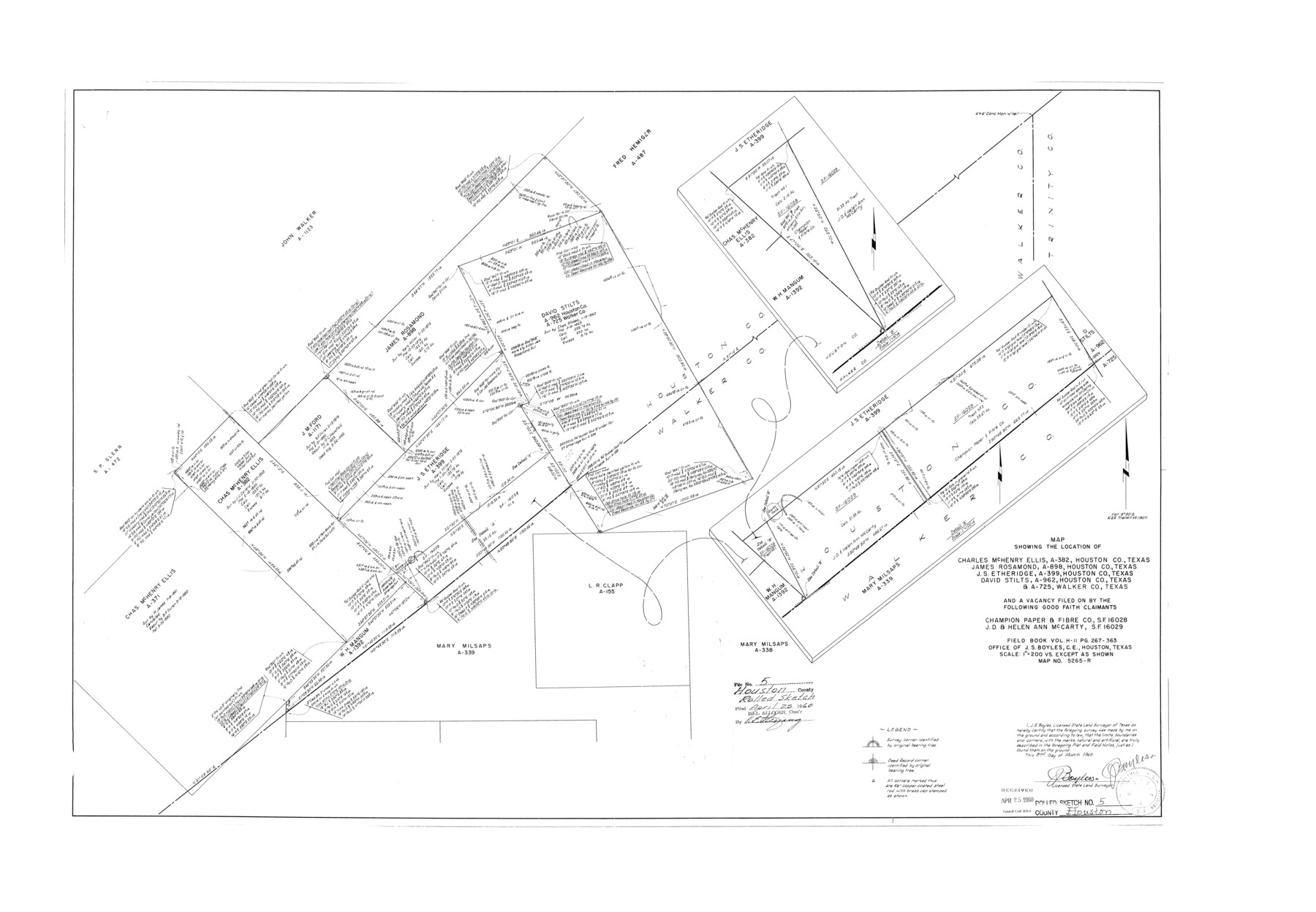
Houston County Rolled Sketch 5
Map showing the location of Ellis A-382, Rosamond A-898, J.S. Etheridge A-399, and D. Stilts A-962 & A-725 (Walker Co.) and a vacancy filed on by the following good faith claimants Champion Paper & Fibre Co., SF-16028, J.D. & Helen Ann McCarty, SF-16029
-
Map/Doc
6227
-
Collection
General Map Collection
-
Object Dates
1960/3/2 (Creation Date)
1960/4/25 (File Date)
-
People and Organizations
J.S. Boyles (Surveyor/Engineer)
-
Counties
Houston Walker
-
Subjects
Surveying Rolled Sketch
-
Height x Width
28.3 x 40.8 inches
71.9 x 103.6 cm
-
Scale
1" = 200 varas
Part of: General Map Collection
Jefferson County Rolled Sketch 58

Print $40.00
- Digital $50.00
Jefferson County Rolled Sketch 58
1897
Size 21.4 x 60.3 inches
Map/Doc 9312
Map of Hamilton County

Print $20.00
- Digital $50.00
Map of Hamilton County
1872
Size 15.0 x 21.9 inches
Map/Doc 4557
DeWitt County Working Sketch Graphic Index

Print $20.00
- Digital $50.00
DeWitt County Working Sketch Graphic Index
1920
Size 39.7 x 46.7 inches
Map/Doc 76522
El Paso County Rolled Sketch 48

Print $20.00
- Digital $50.00
El Paso County Rolled Sketch 48
1960
Size 15.4 x 18.3 inches
Map/Doc 5834
Flight Mission No. DAG-14K, Frame 140, Matagorda County

Print $20.00
- Digital $50.00
Flight Mission No. DAG-14K, Frame 140, Matagorda County
1952
Size 17.6 x 17.6 inches
Map/Doc 86307
El Paso County Rolled Sketch 52

Print $20.00
- Digital $50.00
El Paso County Rolled Sketch 52
1930
Size 18.5 x 24.4 inches
Map/Doc 5837
Flight Mission No. BQR-5K, Frame 64, Brazoria County

Print $20.00
- Digital $50.00
Flight Mission No. BQR-5K, Frame 64, Brazoria County
1952
Size 18.8 x 22.5 inches
Map/Doc 84009
Knox County Sketch File 14

Print $12.00
- Digital $50.00
Knox County Sketch File 14
1892
Size 11.1 x 8.5 inches
Map/Doc 29235
Flight Mission No. CRE-1R, Frame 134, Jackson County

Print $20.00
- Digital $50.00
Flight Mission No. CRE-1R, Frame 134, Jackson County
1956
Size 16.2 x 16.0 inches
Map/Doc 85342
Atascosa County Sketch File 16a

Print $4.00
- Digital $50.00
Atascosa County Sketch File 16a
1878
Size 12.7 x 8.2 inches
Map/Doc 13781
Flight Mission No. CGI-3N, Frame 126, Cameron County

Print $20.00
- Digital $50.00
Flight Mission No. CGI-3N, Frame 126, Cameron County
1954
Size 18.5 x 22.1 inches
Map/Doc 84599
Crockett County Rolled Sketch 95

Print $20.00
- Digital $50.00
Crockett County Rolled Sketch 95
1985
Size 24.6 x 28.8 inches
Map/Doc 5634
You may also like
Crockett County Working Sketch 13

Print $20.00
- Digital $50.00
Crockett County Working Sketch 13
1916
Size 16.6 x 18.5 inches
Map/Doc 68346
Mrs. Alex A. Slaughter Ranch Hockley County, Texas

Print $20.00
- Digital $50.00
Mrs. Alex A. Slaughter Ranch Hockley County, Texas
Size 26.2 x 19.7 inches
Map/Doc 92237
Map of Texas and the country adjacent

Print $20.00
- Digital $50.00
Map of Texas and the country adjacent
1844
Size 18.3 x 26.5 inches
Map/Doc 73052
Concho County

Print $20.00
- Digital $50.00
Concho County
1947
Size 46.8 x 36.9 inches
Map/Doc 73115
Map of Caldwell County, Texas

Print $20.00
Map of Caldwell County, Texas
1880
Size 18.7 x 22.0 inches
Map/Doc 88915
Guadalupe County Sketch File 25

Print $22.00
- Digital $50.00
Guadalupe County Sketch File 25
Size 12.7 x 15.7 inches
Map/Doc 24717
Plat showing proposed counties to be taken from Zapata, Starr & Hidalgo Counties

Print $20.00
- Digital $50.00
Plat showing proposed counties to be taken from Zapata, Starr & Hidalgo Counties
1911
Size 24.8 x 27.0 inches
Map/Doc 2478
Railroad Commissioners' Map of Texas

Print $20.00
Railroad Commissioners' Map of Texas
1897
Size 23.2 x 27.6 inches
Map/Doc 76280
Gaines County Sketch File 2M

Print $20.00
- Digital $50.00
Gaines County Sketch File 2M
1902
Size 20.8 x 29.4 inches
Map/Doc 11522
Location from Del Rio to Johnstone, Southern Pacific Railway Co.

Print $20.00
- Digital $50.00
Location from Del Rio to Johnstone, Southern Pacific Railway Co.
Size 13.3 x 44.3 inches
Map/Doc 64290
Milam County Working Sketch Graphic Index

Print $40.00
- Digital $50.00
Milam County Working Sketch Graphic Index
1975
Size 51.6 x 42.7 inches
Map/Doc 76642
