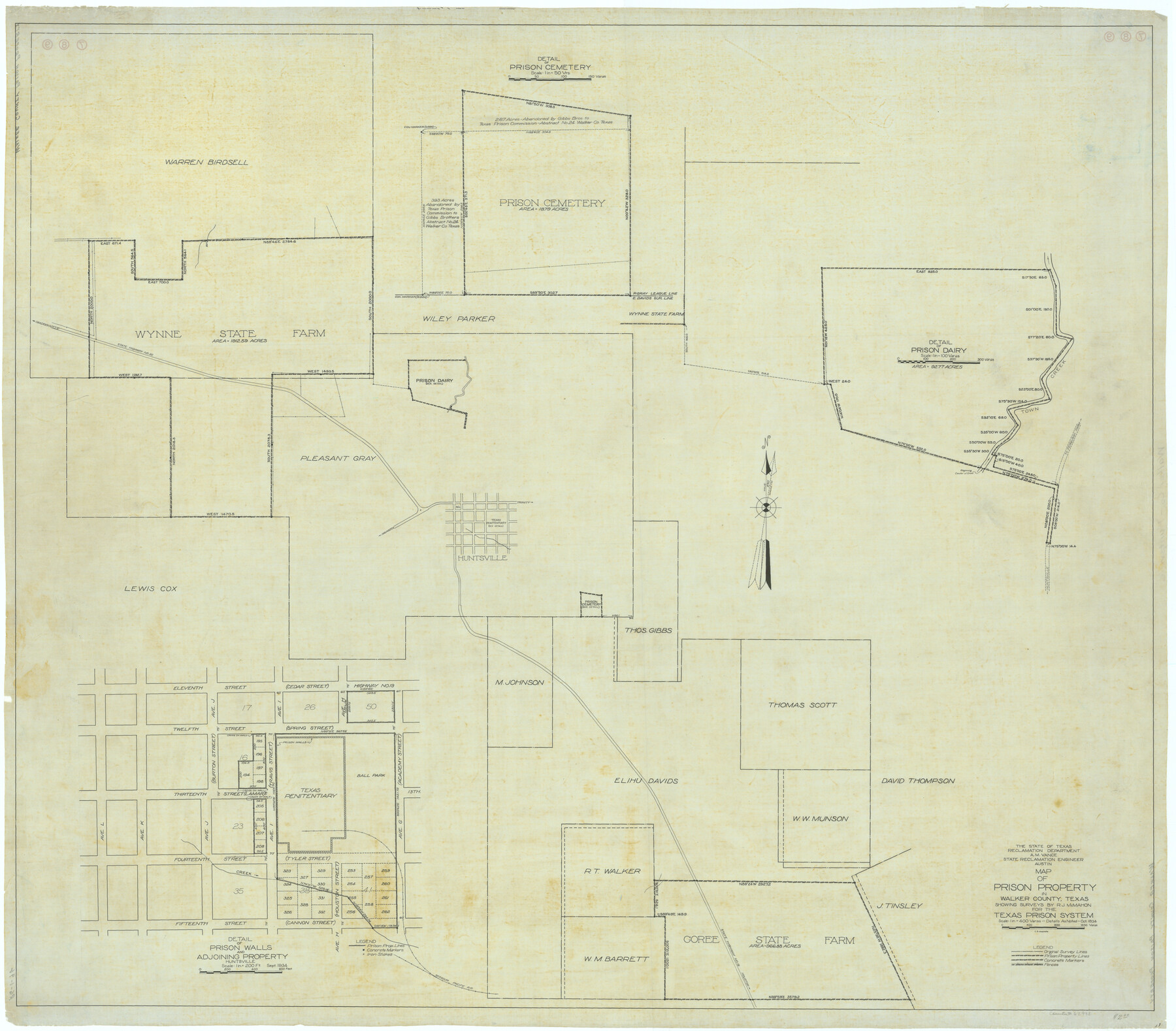
Map of Prison Property in Walker County, Texas
RG-1-9b
-
Map/Doc
62993
-
Collection
General Map Collection
-
People and Organizations
R.J. McMahon (Author)
-
Counties
Walker
-
Height x Width
37.6 x 42.9 inches
95.5 x 109.0 cm
Part of: General Map Collection
Map of subdivision of submerged land in the Gulf of Mexico fronting on Matagorda Island and Peninsula

Print $40.00
- Digital $50.00
Map of subdivision of submerged land in the Gulf of Mexico fronting on Matagorda Island and Peninsula
1940
Size 28.3 x 60.5 inches
Map/Doc 2928
Denton County Working Sketch 26

Print $20.00
- Digital $50.00
Denton County Working Sketch 26
1995
Size 29.3 x 33.9 inches
Map/Doc 68631
Childress County Sketch File 1

Print $16.00
- Digital $50.00
Childress County Sketch File 1
1877
Size 12.8 x 8.3 inches
Map/Doc 18235

Borden County Sketch File 3

Print $4.00
- Digital $50.00
Borden County Sketch File 3
1902
Size 7.3 x 12.8 inches
Map/Doc 14703
Pecos County Working Sketch 104

Print $40.00
- Digital $50.00
Pecos County Working Sketch 104
1971
Size 63.1 x 26.9 inches
Map/Doc 71577
Coke County Rolled Sketch 7

Print $20.00
- Digital $50.00
Coke County Rolled Sketch 7
Size 19.0 x 24.1 inches
Map/Doc 5506
Jasper County Working Sketch 30

Print $20.00
- Digital $50.00
Jasper County Working Sketch 30
1956
Size 33.5 x 38.6 inches
Map/Doc 66492
Frio County Rolled Sketch 3

Print $20.00
- Digital $50.00
Frio County Rolled Sketch 3
Size 30.7 x 20.1 inches
Map/Doc 5916
Menard County Working Sketch 14

Print $20.00
- Digital $50.00
Menard County Working Sketch 14
1939
Size 19.2 x 19.8 inches
Map/Doc 70961
Aransas County Rolled Sketch 1

Print $40.00
- Digital $50.00
Aransas County Rolled Sketch 1
1930
Size 12.5 x 50.0 inches
Map/Doc 8915
Wood County Sketch File 9

Print $4.00
- Digital $50.00
Wood County Sketch File 9
1852
Size 7.4 x 8.9 inches
Map/Doc 40656
You may also like
Crockett County Working Sketch 75

Print $20.00
- Digital $50.00
Crockett County Working Sketch 75
1964
Size 25.7 x 24.0 inches
Map/Doc 68408
Flight Mission No. CUG-3P, Frame 172, Kleberg County

Print $20.00
- Digital $50.00
Flight Mission No. CUG-3P, Frame 172, Kleberg County
1956
Size 18.6 x 22.2 inches
Map/Doc 86292
Sabine County Working Sketch 9

Print $20.00
- Digital $50.00
Sabine County Working Sketch 9
1923
Size 23.9 x 27.1 inches
Map/Doc 63680
Sketch showing position of Asylum Lands Blk. 4, H. & T. C. R.R. Co. & river surveys on north side of Middle Concho, Tom Green Co.

Print $20.00
- Digital $50.00
Sketch showing position of Asylum Lands Blk. 4, H. & T. C. R.R. Co. & river surveys on north side of Middle Concho, Tom Green Co.
Size 14.4 x 20.6 inches
Map/Doc 388
Goliad County Sketch File 23

Print $4.00
- Digital $50.00
Goliad County Sketch File 23
1877
Size 8.1 x 12.8 inches
Map/Doc 24295

Map of Clay Co.

Print $40.00
- Digital $50.00
Map of Clay Co.
1896
Size 51.9 x 31.0 inches
Map/Doc 4785
Panola County

Print $20.00
- Digital $50.00
Panola County
1947
Size 38.6 x 38.2 inches
Map/Doc 77390
Brazoria County Sketch File 44

Print $30.00
- Digital $50.00
Brazoria County Sketch File 44
1946
Size 11.3 x 8.9 inches
Map/Doc 15068
Crockett County Sketch File 90

Print $40.00
- Digital $50.00
Crockett County Sketch File 90
1961
Size 14.7 x 23.5 inches
Map/Doc 11238
[Mrs. May Vinson Survey]
![91869, [Mrs. May Vinson Survey], Twichell Survey Records](https://historictexasmaps.com/wmedia_w700/maps/91869-1.tif.jpg)
Print $20.00
- Digital $50.00
[Mrs. May Vinson Survey]
Size 25.5 x 14.8 inches
Map/Doc 91869
Flight Mission No. DAG-17K, Frame 125, Matagorda County

Print $20.00
- Digital $50.00
Flight Mission No. DAG-17K, Frame 125, Matagorda County
1952
Size 18.6 x 22.4 inches
Map/Doc 86345