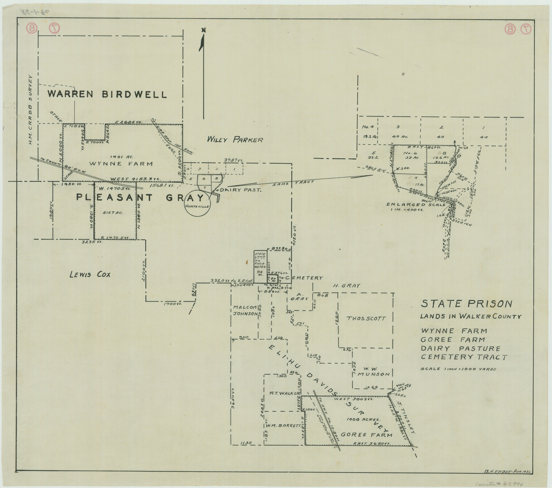
State Prison Lands in Walker County - Wynne Farm, Goree Farm, Dairy Pasture, Cemetery Tract
RG-1-9c
-
Map/Doc
62994
-
Collection
General Map Collection
-
People and Organizations
R.J. McMahon (Author)
-
Counties
Walker
-
Subjects
Prison Farms
-
Height x Width
16.9 x 19.1 inches
42.9 x 48.5 cm
Part of: General Map Collection
Gillespie County Rolled Sketch 3

Print $20.00
- Digital $50.00
Gillespie County Rolled Sketch 3
Size 19.0 x 28.1 inches
Map/Doc 6010
Frio County Rolled Sketch 22

Print $20.00
- Digital $50.00
Frio County Rolled Sketch 22
1962
Size 16.4 x 24.6 inches
Map/Doc 5923
Lee County Working Sketch 21

Print $40.00
- Digital $50.00
Lee County Working Sketch 21
2009
Size 48.7 x 36.6 inches
Map/Doc 89258
Menard County Sketch File 30

Print $4.00
- Digital $50.00
Menard County Sketch File 30
1977
Size 14.3 x 8.6 inches
Map/Doc 31571
Brewster County Rolled Sketch 114

Print $20.00
- Digital $50.00
Brewster County Rolled Sketch 114
1964
Size 17.3 x 11.4 inches
Map/Doc 5292
Ward County Rolled Sketch PMY

Print $40.00
- Digital $50.00
Ward County Rolled Sketch PMY
1935
Size 14.4 x 74.5 inches
Map/Doc 10104
Yoakum County Sketch File 8

Print $20.00
- Digital $50.00
Yoakum County Sketch File 8
Size 25.6 x 29.3 inches
Map/Doc 12705
Baylor County Sketch File A1

Print $40.00
- Digital $50.00
Baylor County Sketch File A1
1899
Size 22.8 x 17.3 inches
Map/Doc 10911
Flight Mission No. DQO-1K, Frame 39, Galveston County

Print $20.00
- Digital $50.00
Flight Mission No. DQO-1K, Frame 39, Galveston County
1952
Size 18.8 x 22.6 inches
Map/Doc 84982
Fannin County Rolled Sketch 18C

Print $20.00
- Digital $50.00
Fannin County Rolled Sketch 18C
Size 16.0 x 12.9 inches
Map/Doc 5870
Flight Mission No. DQN-2K, Frame 124, Calhoun County

Print $20.00
- Digital $50.00
Flight Mission No. DQN-2K, Frame 124, Calhoun County
1953
Size 18.5 x 22.2 inches
Map/Doc 84300
Uvalde County Boundary File 2

Print $5.00
- Digital $50.00
Uvalde County Boundary File 2
Size 13.1 x 9.5 inches
Map/Doc 59556
You may also like
J. De Cordova's Map of the State of Texas Compiled from the records of the General Land Office of the State

Print $20.00
- Digital $50.00
J. De Cordova's Map of the State of Texas Compiled from the records of the General Land Office of the State
1849
Size 36.0 x 34.0 inches
Map/Doc 93930
Hemphill County

Print $20.00
- Digital $50.00
Hemphill County
1899
Size 43.0 x 36.4 inches
Map/Doc 4976
Anderson County Sketch File 32

Print $4.00
- Digital $50.00
Anderson County Sketch File 32
2002
Size 11.3 x 8.8 inches
Map/Doc 78312
Matagorda Bay and Approaches

Print $20.00
- Digital $50.00
Matagorda Bay and Approaches
1946
Size 35.2 x 44.8 inches
Map/Doc 73379
Limestone County Working Sketch 24

Print $20.00
- Digital $50.00
Limestone County Working Sketch 24
1980
Size 28.9 x 31.6 inches
Map/Doc 70574
Sabine Pass and mouth of the River Sabine

Print $20.00
- Digital $50.00
Sabine Pass and mouth of the River Sabine
1840
Size 27.0 x 18.3 inches
Map/Doc 72726
Briscoe County Sketch File M

Print $40.00
- Digital $50.00
Briscoe County Sketch File M
Size 36.1 x 28.0 inches
Map/Doc 11010
Andrews County Working Sketch 31

Print $20.00
- Digital $50.00
Andrews County Working Sketch 31
1990
Size 42.9 x 30.0 inches
Map/Doc 67077
Houston Ship Channel, Alexander Island to Carpenter Bayou

Print $20.00
- Digital $50.00
Houston Ship Channel, Alexander Island to Carpenter Bayou
1975
Size 36.0 x 47.0 inches
Map/Doc 69912
Webb County Working Sketch 52

Print $20.00
- Digital $50.00
Webb County Working Sketch 52
1951
Size 30.8 x 37.3 inches
Map/Doc 72418
Potter County Sketch

Print $20.00
- Digital $50.00
Potter County Sketch
Size 16.3 x 20.9 inches
Map/Doc 91808
Dickens County Sketch File G

Print $8.00
- Digital $50.00
Dickens County Sketch File G
Size 12.0 x 8.7 inches
Map/Doc 20854