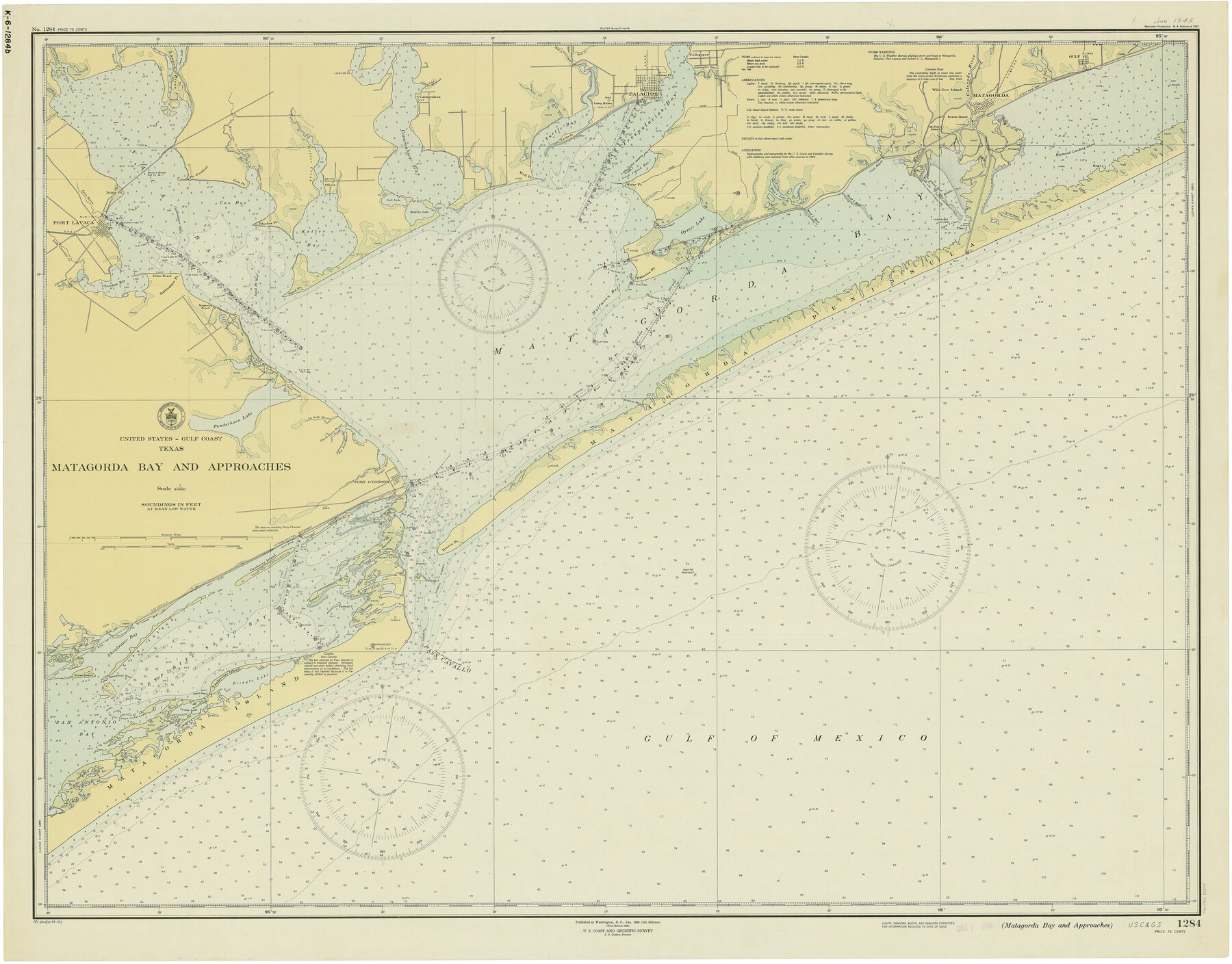
Matagorda Bay and Approaches
K-6-1284a
-
Map/Doc
73379
-
Collection
General Map Collection
-
Object Dates
6/15/1946 (Creation Date)
-
Counties
Matagorda Calhoun Victoria Jackson
-
Subjects
Nautical Charts
-
Height x Width
35.2 x 44.8 inches
89.4 x 113.8 cm
Part of: General Map Collection
Potter County Sketch File 22

Print $30.00
- Digital $50.00
Potter County Sketch File 22
1962
Size 14.2 x 8.6 inches
Map/Doc 34415
San Saba County

Print $40.00
- Digital $50.00
San Saba County
1918
Size 49.0 x 43.0 inches
Map/Doc 63023
Fractional Township No. 8 South Range No. 16 East of the Indian Meridian, Indian Territory

Print $20.00
- Digital $50.00
Fractional Township No. 8 South Range No. 16 East of the Indian Meridian, Indian Territory
1896
Size 19.3 x 24.3 inches
Map/Doc 75228
Webb County Sketch File 73

Print $20.00
- Digital $50.00
Webb County Sketch File 73
2020
Size 11.0 x 8.5 inches
Map/Doc 95917
Val Verde County Sketch File Z17

Print $24.00
- Digital $50.00
Val Verde County Sketch File Z17
1907
Size 23.7 x 17.5 inches
Map/Doc 12558
Jack County Working Sketch 12

Print $20.00
- Digital $50.00
Jack County Working Sketch 12
1959
Size 18.0 x 22.4 inches
Map/Doc 66438
Culberson County Working Sketch 40

Print $40.00
- Digital $50.00
Culberson County Working Sketch 40
1966
Size 35.5 x 60.9 inches
Map/Doc 68493
Duval County Sketch File 4b

Print $4.00
- Digital $50.00
Duval County Sketch File 4b
1874
Size 10.4 x 7.8 inches
Map/Doc 21282
Henderson County Rolled Sketch 11

Print $20.00
- Digital $50.00
Henderson County Rolled Sketch 11
1915
Size 29.3 x 42.6 inches
Map/Doc 75953
[Surveys along the boundary between Jasper and Jefferson Counties]
![99, [Surveys along the boundary between Jasper and Jefferson Counties], General Map Collection](https://historictexasmaps.com/wmedia_w700/maps/99.tif.jpg)
Print $3.00
- Digital $50.00
[Surveys along the boundary between Jasper and Jefferson Counties]
1841
Size 9.3 x 16.9 inches
Map/Doc 99
Gaines County Working Sketch 21

Print $20.00
- Digital $50.00
Gaines County Working Sketch 21
1970
Size 37.8 x 45.4 inches
Map/Doc 69321
Sutton County Sketch File 60

Print $20.00
- Digital $50.00
Sutton County Sketch File 60
Size 34.6 x 43.9 inches
Map/Doc 10378
You may also like
Bowie County Working Sketch 11

Print $20.00
- Digital $50.00
Bowie County Working Sketch 11
1958
Size 43.2 x 31.6 inches
Map/Doc 67415
Floyd County Working Sketch 5

Print $20.00
- Digital $50.00
Floyd County Working Sketch 5
1955
Size 33.3 x 23.6 inches
Map/Doc 69184
Flight Mission No. CUG-1P, Frame 75, Kleberg County

Print $20.00
- Digital $50.00
Flight Mission No. CUG-1P, Frame 75, Kleberg County
1956
Size 18.5 x 22.3 inches
Map/Doc 86140
Flight Mission No. DAG-21K, Frame 104, Matagorda County

Print $20.00
- Digital $50.00
Flight Mission No. DAG-21K, Frame 104, Matagorda County
1952
Size 18.7 x 22.3 inches
Map/Doc 86432
Hunt County Working Sketch 6

Print $20.00
- Digital $50.00
Hunt County Working Sketch 6
1942
Size 31.0 x 40.3 inches
Map/Doc 66353
Cooke County Working Sketch 12

Print $20.00
- Digital $50.00
Cooke County Working Sketch 12
1944
Size 25.2 x 23.0 inches
Map/Doc 68249
Montgomery County Rolled Sketch 42

Print $20.00
- Digital $50.00
Montgomery County Rolled Sketch 42
1939
Size 13.9 x 20.2 inches
Map/Doc 6816
Hamilton County Working Sketch 28

Print $20.00
- Digital $50.00
Hamilton County Working Sketch 28
1976
Size 27.7 x 33.2 inches
Map/Doc 63366
Flight Mission No. CZW-1R, Frame 116, Hardeman County

Print $20.00
- Digital $50.00
Flight Mission No. CZW-1R, Frame 116, Hardeman County
1956
Size 18.6 x 19.0 inches
Map/Doc 85235
Plat of tract surveyed for S. W. Inglish

Print $20.00
- Digital $50.00
Plat of tract surveyed for S. W. Inglish
1920
Size 18.2 x 6.7 inches
Map/Doc 90822
Stonewall County Rolled Sketch 20

Print $40.00
- Digital $50.00
Stonewall County Rolled Sketch 20
1951
Size 30.1 x 55.4 inches
Map/Doc 63915
Cooke County Working Sketch 9

Print $20.00
- Digital $50.00
Cooke County Working Sketch 9
1940
Size 40.6 x 27.9 inches
Map/Doc 68246