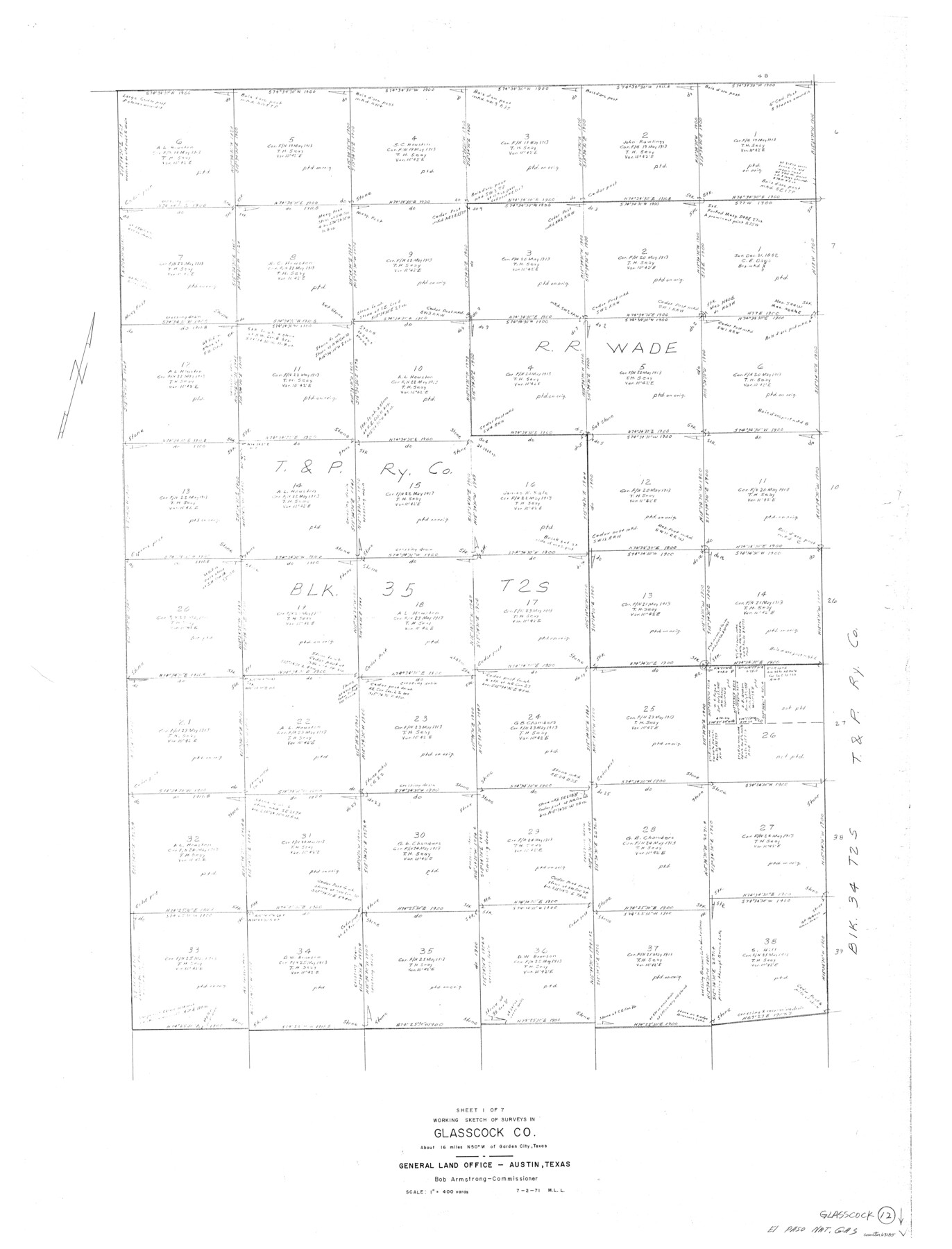
Glasscock County Working Sketch 12
-
Map/Doc
63185
-
Collection
General Map Collection
-
Object Dates
7/2/1971 (Creation Date)
-
People and Organizations
M. L. Liles (Draftsman)
-
Counties
Glasscock
-
Subjects
Surveying Working Sketch
-
Height x Width
51.2 x 39.0 inches
130.1 x 99.1 cm
-
Scale
1" = 400 varas
Part of: General Map Collection
Brewster County Working Sketch 29

Print $20.00
- Digital $50.00
Brewster County Working Sketch 29
1941
Size 19.1 x 31.2 inches
Map/Doc 67563
Flight Mission No. DQN-5K, Frame 26, Calhoun County

Print $20.00
- Digital $50.00
Flight Mission No. DQN-5K, Frame 26, Calhoun County
1953
Size 18.6 x 22.3 inches
Map/Doc 84377
Map of Bexar County

Print $20.00
- Digital $50.00
Map of Bexar County
1878
Size 24.5 x 27.6 inches
Map/Doc 3298

Presidio County Working Sketch 86

Print $20.00
- Digital $50.00
Presidio County Working Sketch 86
1971
Size 45.4 x 42.2 inches
Map/Doc 71763
Andrews County Rolled Sketch 18

Print $20.00
- Digital $50.00
Andrews County Rolled Sketch 18
1942
Size 26.0 x 31.3 inches
Map/Doc 8394
Starr County Rolled Sketch X

Print $121.00
- Digital $50.00
Starr County Rolled Sketch X
Size 13.3 x 8.1 inches
Map/Doc 75961
McLennan County Working Sketch 5

Print $20.00
- Digital $50.00
McLennan County Working Sketch 5
1943
Size 14.6 x 12.8 inches
Map/Doc 70698
Brewster County Working Sketch 50

Print $40.00
- Digital $50.00
Brewster County Working Sketch 50
1950
Size 31.5 x 48.4 inches
Map/Doc 67584
Webb County Rolled Sketch 36

Print $20.00
- Digital $50.00
Webb County Rolled Sketch 36
1940
Size 12.8 x 24.2 inches
Map/Doc 8191
South Part Presidio County

Print $20.00
- Digital $50.00
South Part Presidio County
1975
Size 35.0 x 40.3 inches
Map/Doc 95617
Collin County Boundary File 4 and 4a

Print $160.00
- Digital $50.00
Collin County Boundary File 4 and 4a
Size 11.9 x 8.5 inches
Map/Doc 51691
You may also like
Marion County Sketch File 15

Print $10.00
- Digital $50.00
Marion County Sketch File 15
1958
Size 14.3 x 8.8 inches
Map/Doc 30585
Flight Mission No. CGI-3N, Frame 179, Cameron County

Print $20.00
- Digital $50.00
Flight Mission No. CGI-3N, Frame 179, Cameron County
1954
Size 18.6 x 22.2 inches
Map/Doc 84643
Tom Green County Sketch File 2

Print $4.00
- Digital $50.00
Tom Green County Sketch File 2
Size 9.6 x 7.6 inches
Map/Doc 38161
Right of Way & Track Map, St. Louis, Brownsville & Mexico Ry. operated by St. Louis, Brownsville & Mexico Ry. Co.

Print $40.00
- Digital $50.00
Right of Way & Track Map, St. Louis, Brownsville & Mexico Ry. operated by St. Louis, Brownsville & Mexico Ry. Co.
1919
Size 25.8 x 56.9 inches
Map/Doc 64620
Right-of-Way and Track Map, Texas State Railroad operated by the T. and N. O. R.R. Co.

Print $40.00
- Digital $50.00
Right-of-Way and Track Map, Texas State Railroad operated by the T. and N. O. R.R. Co.
1918
Size 24.5 x 56.1 inches
Map/Doc 64178
Atascosa County Rolled Sketch 5B1

Print $20.00
- Digital $50.00
Atascosa County Rolled Sketch 5B1
Size 14.6 x 11.7 inches
Map/Doc 5090
Flight Mission No. DAG-14K, Frame 133, Matagorda County

Print $20.00
- Digital $50.00
Flight Mission No. DAG-14K, Frame 133, Matagorda County
1952
Size 17.6 x 17.4 inches
Map/Doc 86304
[Garza County School Land and Vicinity]
![91294, [Garza County School Land and Vicinity], Twichell Survey Records](https://historictexasmaps.com/wmedia_w700/maps/91294-1.tif.jpg)
Print $3.00
- Digital $50.00
[Garza County School Land and Vicinity]
Size 13.4 x 11.9 inches
Map/Doc 91294
Travis County Appraisal District Plat Map 3_0206

Print $20.00
- Digital $50.00
Travis County Appraisal District Plat Map 3_0206
Size 21.4 x 26.4 inches
Map/Doc 94225
Starr County Sketch File 17

Print $24.00
- Digital $50.00
Starr County Sketch File 17
1880
Size 12.8 x 8.2 inches
Map/Doc 36874
Terrell County Working Sketch 39

Print $20.00
- Digital $50.00
Terrell County Working Sketch 39
1951
Size 26.8 x 40.4 inches
Map/Doc 62132
Flight Mission No. BQR-9K, Frame 10, Brazoria County

Print $20.00
- Digital $50.00
Flight Mission No. BQR-9K, Frame 10, Brazoria County
1952
Size 18.7 x 22.3 inches
Map/Doc 84039