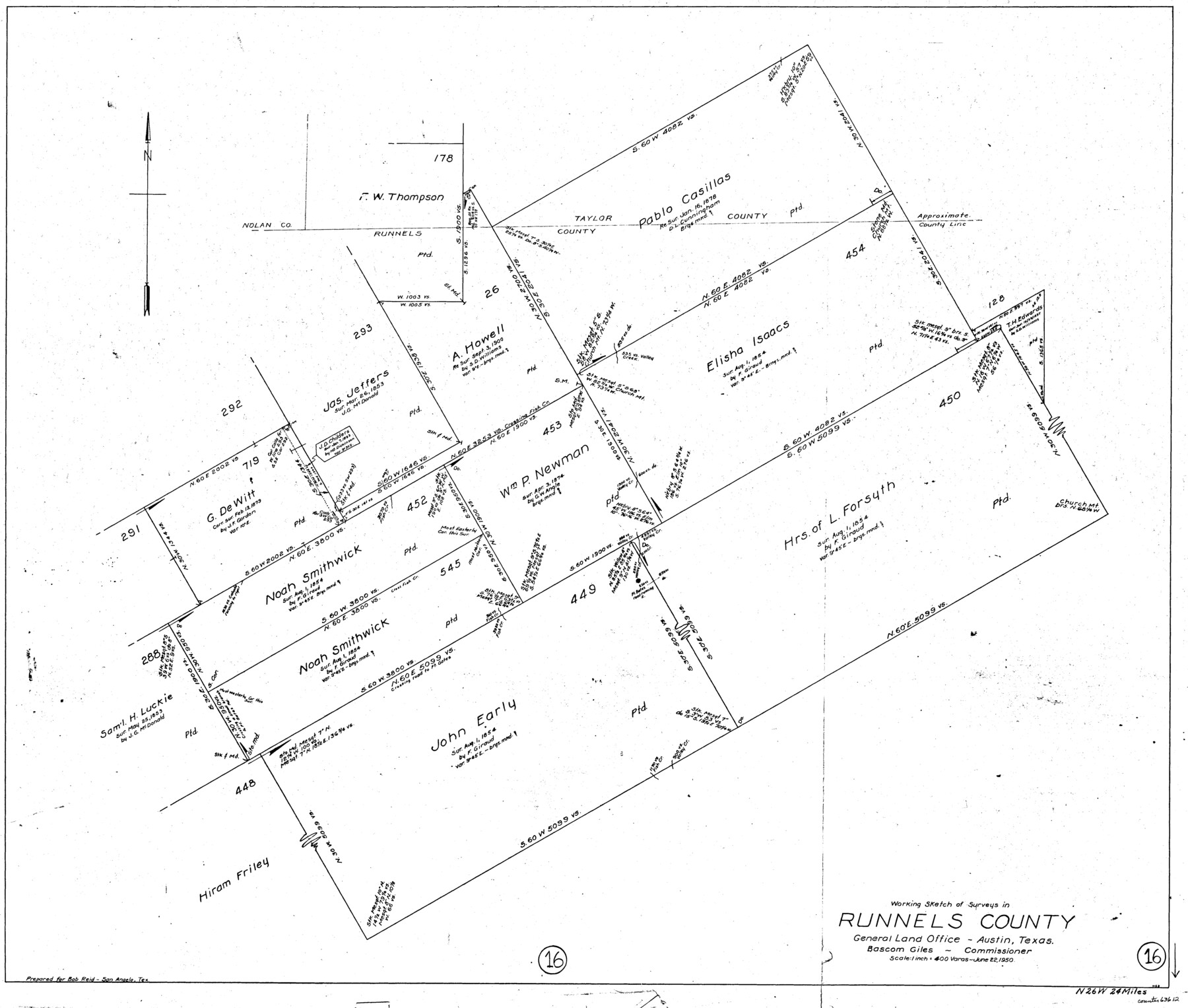
Runnels County Working Sketch 16
-
Map/Doc
63612
-
Collection
General Map Collection
-
Object Dates
6/22/1950 (Creation Date)
-
People and Organizations
W. S. Brewington (Draftsman)
-
Counties
Runnels Taylor
-
Subjects
Surveying Working Sketch
-
Height x Width
30.1 x 35.5 inches
76.5 x 90.2 cm
-
Scale
1" = 400 varas
Part of: General Map Collection
Hemphill County Rolled Sketch MJ

Print $20.00
- Digital $50.00
Hemphill County Rolled Sketch MJ
Size 21.3 x 41.4 inches
Map/Doc 6201
Fannin County Sketch File 15

Print $6.00
- Digital $50.00
Fannin County Sketch File 15
1866
Size 8.2 x 8.2 inches
Map/Doc 22466
[Sketch for Mineral Applications 7410, 7411, 7412, 7413, 7712 - Kleberg County]
![65624, [Sketch for Mineral Applications 7410, 7411, 7412, 7413, 7712 - Kleberg County], General Map Collection](https://historictexasmaps.com/wmedia_w700/maps/65624-1.tif.jpg)
Print $40.00
- Digital $50.00
[Sketch for Mineral Applications 7410, 7411, 7412, 7413, 7712 - Kleberg County]
1977
Size 91.9 x 44.5 inches
Map/Doc 65624
Flight Mission No. DAG-26K, Frame 63, Matagorda County

Print $20.00
- Digital $50.00
Flight Mission No. DAG-26K, Frame 63, Matagorda County
1953
Size 18.5 x 22.2 inches
Map/Doc 86583
Crockett County Sketch File 15

Print $24.00
- Digital $50.00
Crockett County Sketch File 15
1880
Size 9.1 x 8.0 inches
Map/Doc 19666
Revised Map of Jefferson County Texas

Print $20.00
- Digital $50.00
Revised Map of Jefferson County Texas
1898
Size 30.1 x 24.5 inches
Map/Doc 78177
Louisiana and Texas Intracoastal Waterway - Entrance near Port O'Connor, Texas, Survey of September, 1940

Print $20.00
- Digital $50.00
Louisiana and Texas Intracoastal Waterway - Entrance near Port O'Connor, Texas, Survey of September, 1940
1940
Size 31.2 x 41.5 inches
Map/Doc 61822
Plat of Location and Right of Way from El Paso, Tex. To New Mexico Line, Rio Grande and El Paso R. R.

Print $40.00
- Digital $50.00
Plat of Location and Right of Way from El Paso, Tex. To New Mexico Line, Rio Grande and El Paso R. R.
Size 22.5 x 121.3 inches
Map/Doc 64083
Brewster County Working Sketch 92

Print $40.00
- Digital $50.00
Brewster County Working Sketch 92
1975
Size 61.9 x 39.4 inches
Map/Doc 67692
El Paso County State Real Property Sketch 3

Print $20.00
- Digital $50.00
El Paso County State Real Property Sketch 3
2012
Size 25.1 x 36.4 inches
Map/Doc 93700
The Texas and Pacific Ry. Co., Station Map, Colorado, Texas

Print $20.00
- Digital $50.00
The Texas and Pacific Ry. Co., Station Map, Colorado, Texas
Size 11.7 x 18.8 inches
Map/Doc 64677
The Coast of New Spain from Neuva Vera Cruz to Triste Island

Print $20.00
- Digital $50.00
The Coast of New Spain from Neuva Vera Cruz to Triste Island
1775
Size 21.0 x 28.9 inches
Map/Doc 95919
You may also like
Williamson County Working Sketch 18

Print $20.00
- Digital $50.00
Williamson County Working Sketch 18
1985
Size 26.1 x 26.6 inches
Map/Doc 72578

Supreme Court of the United States, October Term, 1924, No. 13, Original - The State of Oklahoma, Complainant vs. The State of Texas, Defendant, The United States, Intervener

Print $20.00
- Digital $50.00
Supreme Court of the United States, October Term, 1924, No. 13, Original - The State of Oklahoma, Complainant vs. The State of Texas, Defendant, The United States, Intervener
1924
Size 22.1 x 38.7 inches
Map/Doc 75130
Comanche County Working Sketch 30

Print $20.00
- Digital $50.00
Comanche County Working Sketch 30
1988
Size 18.8 x 28.2 inches
Map/Doc 68164
[Right of Way & Track Map, The Texas & Pacific Ry. Co. Main Line]
![64689, [Right of Way & Track Map, The Texas & Pacific Ry. Co. Main Line], General Map Collection](https://historictexasmaps.com/wmedia_w700/maps/64689.tif.jpg)
Print $20.00
- Digital $50.00
[Right of Way & Track Map, The Texas & Pacific Ry. Co. Main Line]
Size 11.0 x 19.0 inches
Map/Doc 64689
Maps of Gulf Intracoastal Waterway, Texas - Sabine River to the Rio Grande and connecting waterways including ship channels

Print $20.00
- Digital $50.00
Maps of Gulf Intracoastal Waterway, Texas - Sabine River to the Rio Grande and connecting waterways including ship channels
1966
Size 14.5 x 22.2 inches
Map/Doc 61927
Parker County Sketch File 48

Print $20.00
- Digital $50.00
Parker County Sketch File 48
1858
Size 17.6 x 22.3 inches
Map/Doc 12152
Starr County Sketch File 34

Print $20.00
- Digital $50.00
Starr County Sketch File 34
1939
Size 15.8 x 17.6 inches
Map/Doc 12337
Pecos County Rolled Sketch 131

Print $20.00
- Digital $50.00
Pecos County Rolled Sketch 131
1950
Size 28.6 x 26.4 inches
Map/Doc 7269
Tom Green County Sketch File 88

Print $8.00
- Digital $50.00
Tom Green County Sketch File 88
1990
Size 11.5 x 8.9 inches
Map/Doc 38266
McLennan County Sketch File 3

Print $4.00
- Digital $50.00
McLennan County Sketch File 3
1857
Size 11.1 x 8.1 inches
Map/Doc 31233
Kendall County Sketch File 2

Print $6.00
- Digital $50.00
Kendall County Sketch File 2
1847
Size 14.6 x 10.9 inches
Map/Doc 28682