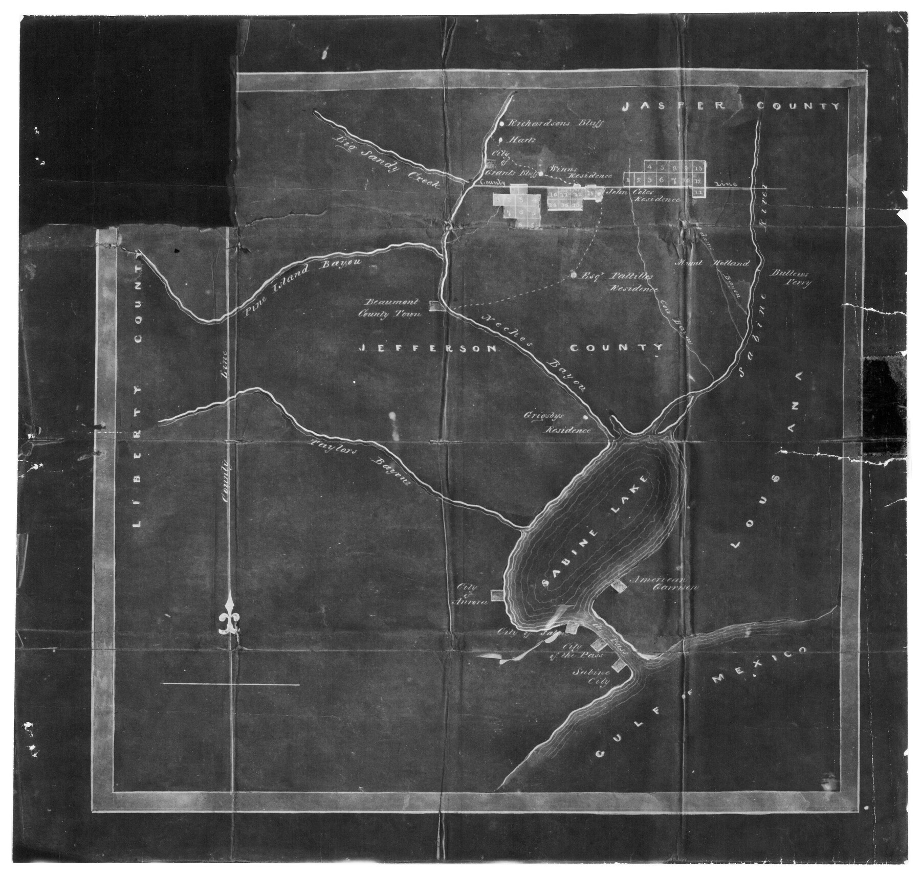
Jefferson County Rolled Sketch 21
[Old sketch of Sabine Lake and bayous]
-
Map/Doc
6386
-
Collection
General Map Collection
-
Object Dates
9/21/1932 (File Date)
-
Counties
Jefferson
-
Subjects
Surveying Rolled Sketch
-
Height x Width
12.6 x 12.1 inches
32.0 x 30.7 cm
-
Medium
photostat
Part of: General Map Collection
Reeves County Rolled Sketch 35

Print $20.00
- Digital $50.00
Reeves County Rolled Sketch 35
2013
Size 25.3 x 36.8 inches
Map/Doc 93706
Atascosa County

Print $20.00
- Digital $50.00
Atascosa County
1948
Size 47.6 x 44.9 inches
Map/Doc 77204
J. De Cordova's Map of the State of Texas Compiled from the records of the General Land Office of the State

Print $20.00
- Digital $50.00
J. De Cordova's Map of the State of Texas Compiled from the records of the General Land Office of the State
1851
Size 34.9 x 32.0 inches
Map/Doc 442
Copano, St. Charles, Aransas and Red Fish Bays, in Aransas and Nueces Counties, showing Subdivision for Mineral Development

Print $40.00
- Digital $50.00
Copano, St. Charles, Aransas and Red Fish Bays, in Aransas and Nueces Counties, showing Subdivision for Mineral Development
1949
Size 55.9 x 40.0 inches
Map/Doc 1914
Flight Mission No. CRC-4R, Frame 109, Chambers County

Print $20.00
- Digital $50.00
Flight Mission No. CRC-4R, Frame 109, Chambers County
1956
Size 18.5 x 22.5 inches
Map/Doc 84906
[Surveys along the Salado and Lampasas Rivers and Saltillo Creek]
![362, [Surveys along the Salado and Lampasas Rivers and Saltillo Creek], General Map Collection](https://historictexasmaps.com/wmedia_w700/maps/362.tif.jpg)
Print $2.00
- Digital $50.00
[Surveys along the Salado and Lampasas Rivers and Saltillo Creek]
1845
Size 13.1 x 7.8 inches
Map/Doc 362

Real County Rolled Sketch 18

Print $20.00
- Digital $50.00
Real County Rolled Sketch 18
1986
Size 25.3 x 32.5 inches
Map/Doc 7469
Sketch showing progress of topographical work Laguna Madre and vicinity from Rainey Is. to Baffins Bay, Coast of Texas Sect. IX [and accompanying letter]
![72958, Sketch showing progress of topographical work Laguna Madre and vicinity from Rainey Is. to Baffins Bay, Coast of Texas Sect. IX [and accompanying letter], General Map Collection](https://historictexasmaps.com/wmedia_w700/maps/72958.tif.jpg)
Print $2.00
- Digital $50.00
Sketch showing progress of topographical work Laguna Madre and vicinity from Rainey Is. to Baffins Bay, Coast of Texas Sect. IX [and accompanying letter]
1881
Size 11.2 x 8.8 inches
Map/Doc 72958
Crockett County Sketch File 46

Print $20.00
- Digital $50.00
Crockett County Sketch File 46
Size 11.1 x 8.7 inches
Map/Doc 19779
Shackelford County Sketch File 15

Print $16.00
- Digital $50.00
Shackelford County Sketch File 15
1998
Size 14.2 x 8.8 inches
Map/Doc 62202
Flight Mission No. DAG-19K, Frame 56, Matagorda County

Print $20.00
- Digital $50.00
Flight Mission No. DAG-19K, Frame 56, Matagorda County
1952
Size 18.5 x 22.3 inches
Map/Doc 86383
You may also like
Jefferson County Working Sketch 24

Print $20.00
- Digital $50.00
Jefferson County Working Sketch 24
1977
Size 28.4 x 44.5 inches
Map/Doc 66567
General Highway Map, Fort Bend County, Texas

Print $20.00
General Highway Map, Fort Bend County, Texas
1939
Size 18.6 x 25.2 inches
Map/Doc 79093
Flight Mission No. CLL-3N, Frame 38, Willacy County

Print $20.00
- Digital $50.00
Flight Mission No. CLL-3N, Frame 38, Willacy County
1954
Size 18.6 x 22.2 inches
Map/Doc 87096
Palo Pinto County

Print $20.00
- Digital $50.00
Palo Pinto County
1896
Size 27.2 x 22.1 inches
Map/Doc 3937
Wilbarger County Working Sketch 4

Print $20.00
- Digital $50.00
Wilbarger County Working Sketch 4
1925
Size 14.6 x 17.1 inches
Map/Doc 72542
[H. & G.N. RR. Co. Block 4 and vicinity]
![92160, [H. & G.N. RR. Co. Block 4 and vicinity], Twichell Survey Records](https://historictexasmaps.com/wmedia_w700/maps/92160-1.tif.jpg)
Print $20.00
- Digital $50.00
[H. & G.N. RR. Co. Block 4 and vicinity]
Size 40.8 x 37.4 inches
Map/Doc 92160
Map Showing the position of surveys 1 & 2, B.S. & F. Cert 1/356

Print $20.00
- Digital $50.00
Map Showing the position of surveys 1 & 2, B.S. & F. Cert 1/356
1915
Size 22.0 x 11.1 inches
Map/Doc 10768
Harris County Sketch File 32a

Print $4.00
- Digital $50.00
Harris County Sketch File 32a
1895
Size 14.1 x 9.0 inches
Map/Doc 25436
Hays County Boundary File 3

Print $20.00
- Digital $50.00
Hays County Boundary File 3
Size 11.2 x 8.8 inches
Map/Doc 54597
Colorado County Rolled Sketch 7

Print $20.00
- Digital $50.00
Colorado County Rolled Sketch 7
1997
Size 26.2 x 19.1 inches
Map/Doc 5534
Titus County Working Sketch 1

Print $20.00
- Digital $50.00
Titus County Working Sketch 1
Size 18.2 x 17.3 inches
Map/Doc 69362
Flight Mission No. CUG-3P, Frame 169, Kleberg County

Print $20.00
- Digital $50.00
Flight Mission No. CUG-3P, Frame 169, Kleberg County
1956
Size 18.5 x 22.2 inches
Map/Doc 86289