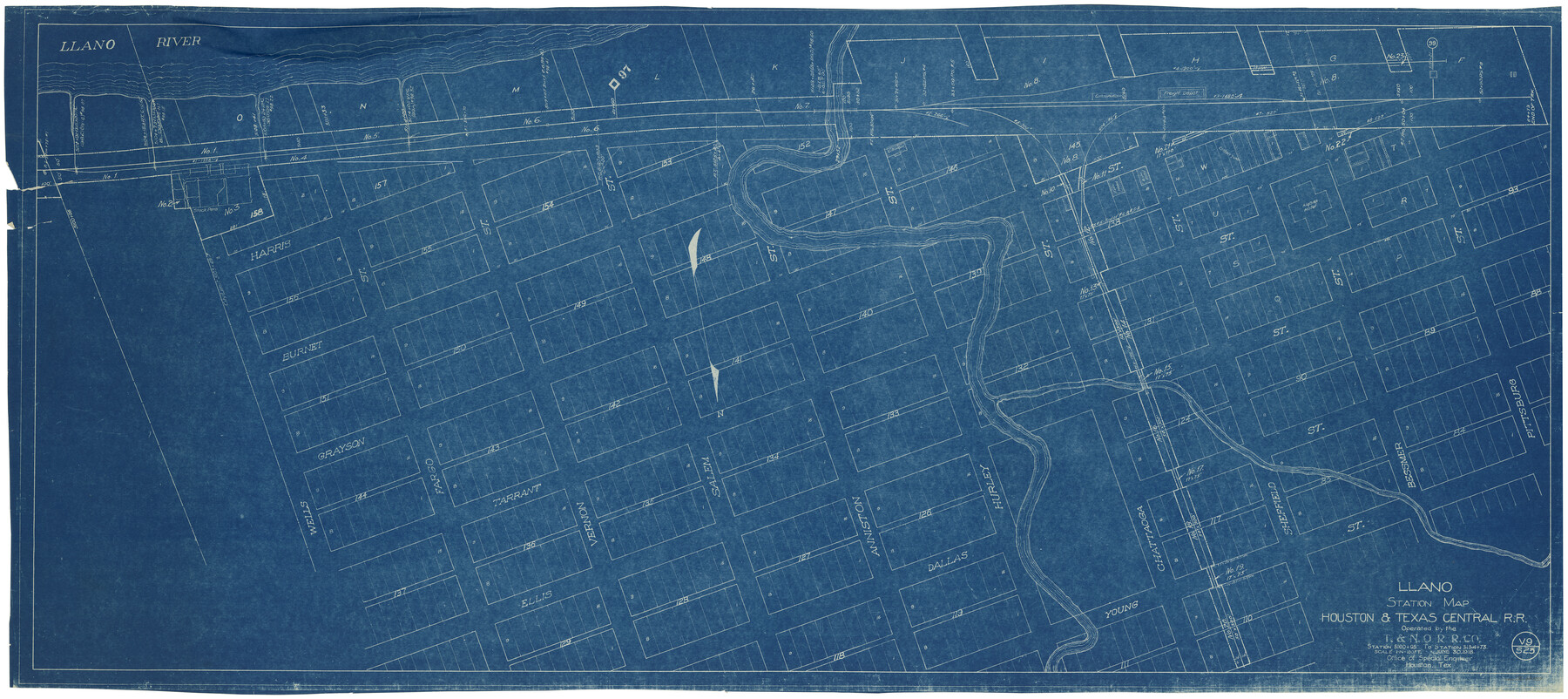
Llano Station Map, Houston & Texas Central R.R. operated by the T. & N. O. R.R. Co.
Station 5100+95 to Station 5154+73
Z-2-172
-
Map/Doc
64559
-
Collection
General Map Collection
-
Object Dates
6/30/1918 (Creation Date)
12/31/1927 (Revision Date)
12/31/1930 (Revision Date)
-
Counties
Llano
-
Subjects
Railroads
-
Height x Width
25.8 x 57.1 inches
65.5 x 145.0 cm
-
Medium
blueprint/diazo
-
Scale
1" = 100 feet
-
Comments
Texas and New Orleans Railroad; Austin Branch.
See counter nos. 64553 through 64558 for other sheets of the map. -
Features
H&TC
Llano River
[Llano]
Part of: General Map Collection
Bowie County Sketch File A

Print $40.00
- Digital $50.00
Bowie County Sketch File A
1902
Size 15.6 x 27.3 inches
Map/Doc 10946
Kleberg County

Print $20.00
- Digital $50.00
Kleberg County
1913
Size 25.6 x 32.8 inches
Map/Doc 1878
Freestone County Sketch File 7

Print $4.00
- Digital $50.00
Freestone County Sketch File 7
1861
Size 14.4 x 8.3 inches
Map/Doc 23052
Foard County Boundary File 5

Print $20.00
- Digital $50.00
Foard County Boundary File 5
Size 10.3 x 8.8 inches
Map/Doc 53536
Roberts County Working Sketch 28

Print $20.00
- Digital $50.00
Roberts County Working Sketch 28
1983
Size 39.7 x 29.8 inches
Map/Doc 63554

Map of the District of San Patricio and Nueces

Print $40.00
- Digital $50.00
Map of the District of San Patricio and Nueces
Size 93.8 x 67.5 inches
Map/Doc 1955
Gonzales County Rolled Sketch 1

Print $20.00
- Digital $50.00
Gonzales County Rolled Sketch 1
1917
Size 21.9 x 23.9 inches
Map/Doc 6027
Gaines County Working Sketch 6

Print $20.00
- Digital $50.00
Gaines County Working Sketch 6
1940
Size 25.0 x 40.8 inches
Map/Doc 69306
Jones County Rolled Sketch 1

Print $20.00
- Digital $50.00
Jones County Rolled Sketch 1
1957
Size 26.1 x 28.3 inches
Map/Doc 6450
Runnels County Sketch File 19 and 22

Print $48.00
Runnels County Sketch File 19 and 22
1887
Size 14.0 x 21.2 inches
Map/Doc 12254
Henderson County Boundary File 2a

Print $12.00
- Digital $50.00
Henderson County Boundary File 2a
Size 14.2 x 8.8 inches
Map/Doc 54656
You may also like
Atascosa County Rolled Sketch R

Print $20.00
- Digital $50.00
Atascosa County Rolled Sketch R
Size 19.6 x 19.6 inches
Map/Doc 5103
Uvalde County Sketch File 12

Print $18.00
- Digital $50.00
Uvalde County Sketch File 12
1887
Size 9.3 x 17.0 inches
Map/Doc 38977
Jeff Davis County Sketch File 4

Print $42.00
- Digital $50.00
Jeff Davis County Sketch File 4
1889
Size 12.5 x 14.7 inches
Map/Doc 27893
Presidio County Working Sketch 134

Print $40.00
- Digital $50.00
Presidio County Working Sketch 134
1989
Size 37.0 x 55.6 inches
Map/Doc 71812
Denton County Sketch File 12

Print $4.00
- Digital $50.00
Denton County Sketch File 12
1856
Size 8.3 x 10.3 inches
Map/Doc 20711
Nolan County Working Sketch 4

Print $20.00
- Digital $50.00
Nolan County Working Sketch 4
1948
Size 21.6 x 28.9 inches
Map/Doc 71295
Bee County Working Sketch 33

Print $20.00
- Digital $50.00
Bee County Working Sketch 33
1980
Size 32.0 x 28.2 inches
Map/Doc 67284
Presidio County Sketch File 95

Print $22.00
- Digital $50.00
Presidio County Sketch File 95
1958
Size 12.7 x 16.4 inches
Map/Doc 34773
Corpus Christi Bay in Nueces County, showing Subdivision for Mineral Development

Print $40.00
- Digital $50.00
Corpus Christi Bay in Nueces County, showing Subdivision for Mineral Development
1950
Size 48.4 x 36.0 inches
Map/Doc 1917
Lampasas County Boundary File Index

Print $2.00
- Digital $50.00
Lampasas County Boundary File Index
Size 9.0 x 9.6 inches
Map/Doc 56092
Colorado River, Wharton to Bay City Sheet 1, Texas

Print $40.00
- Digital $50.00
Colorado River, Wharton to Bay City Sheet 1, Texas
1924
Size 73.9 x 38.9 inches
Map/Doc 65262
El Paso County Working Sketch 54

Print $20.00
- Digital $50.00
El Paso County Working Sketch 54
1992
Size 31.5 x 29.0 inches
Map/Doc 69076