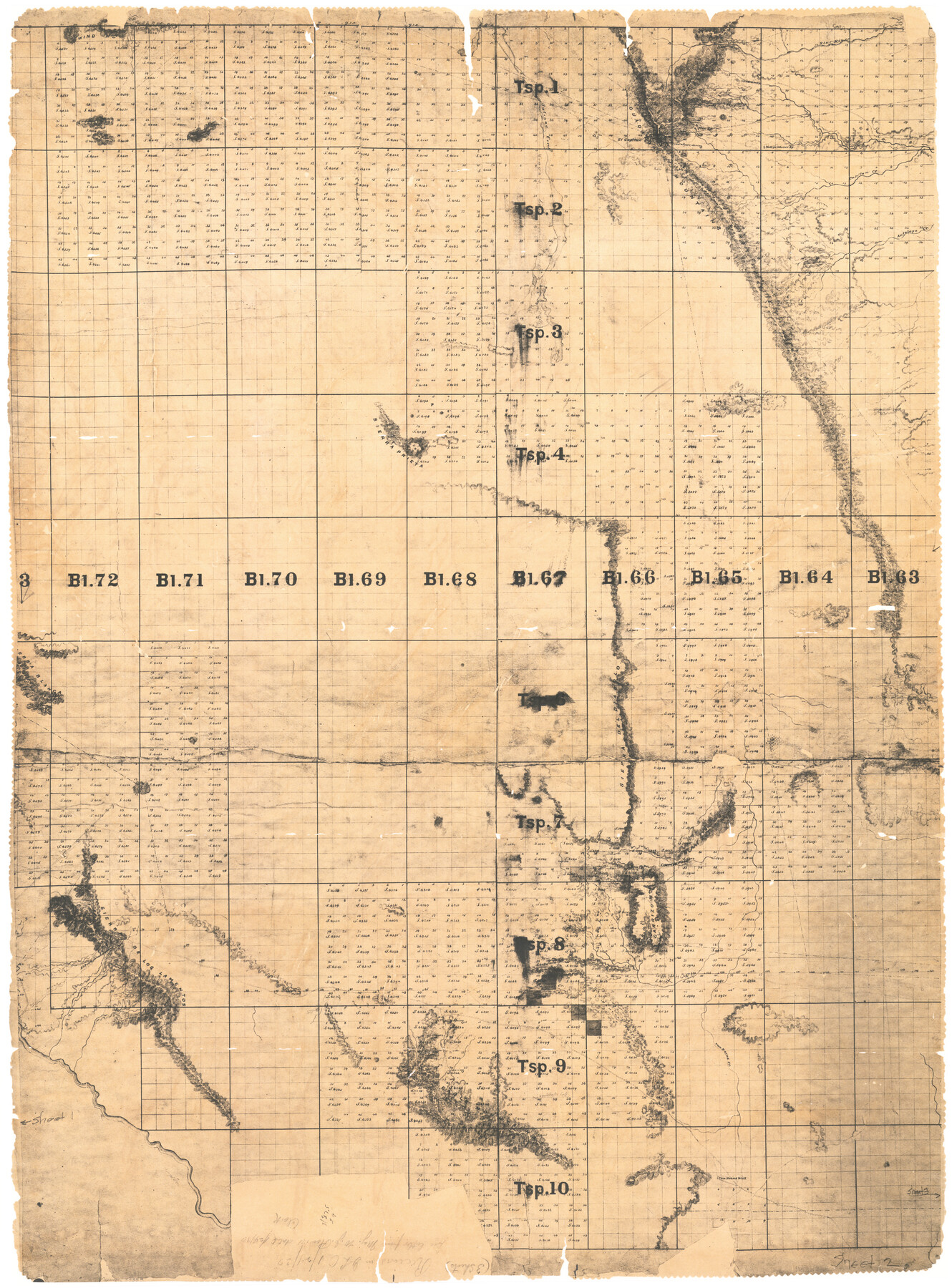
Map of the Texas & Pacific Ry. Reserve West of the Pecos River
K-7-34
-
Map/Doc
65333
-
Collection
General Map Collection
-
Object Dates
1879 (Creation Date)
1930/1/24 (File Date)
-
People and Organizations
Jacob Kuechler (Surveyor/Engineer)
Jacob Kuechler (Compiler)
-
Counties
Pecos El Paso
-
Subjects
Texas and Pacific Railroad
-
Height x Width
40.8 x 30.2 inches
103.6 x 76.7 cm
-
Comments
Sheet 2 of 3. For sheet 1 see 65334 and for sheet 3 see 65332. For a digital composite of all three sheets see 96439
Related maps
Map of the Texas & Pacific Ry. Reserve West of the Pecos River

Print $20.00
- Digital $50.00
Map of the Texas & Pacific Ry. Reserve West of the Pecos River
1879
Size 41.1 x 29.8 inches
Map/Doc 65332
Map of the Texas & Pacific Ry. Reserve West of the Pecos River

Print $20.00
- Digital $50.00
Map of the Texas & Pacific Ry. Reserve West of the Pecos River
1879
Size 41.2 x 29.9 inches
Map/Doc 65334
Map of the Texas & Pacific Ry. Reserve West of the Pecos River

Print $40.00
- Digital $50.00
Map of the Texas & Pacific Ry. Reserve West of the Pecos River
1879
Size 55.4 x 118.1 inches
Map/Doc 96439
Part of: General Map Collection
Brazoria County Sketch File 12a

Print $4.00
- Digital $50.00
Brazoria County Sketch File 12a
1886
Size 11.2 x 8.5 inches
Map/Doc 14971
Map of Surveys Made for the T&PRRCo in Tom Green & Martin Counties, Blocks 40, 41, 42, 43, 44, 45 & 46, Reserve West of the Colorado

Print $20.00
- Digital $50.00
Map of Surveys Made for the T&PRRCo in Tom Green & Martin Counties, Blocks 40, 41, 42, 43, 44, 45 & 46, Reserve West of the Colorado
1876
Size 42.3 x 46.0 inches
Map/Doc 2227
Harris County Boundary File 39 (12)

Print $4.00
- Digital $50.00
Harris County Boundary File 39 (12)
Size 7.7 x 8.1 inches
Map/Doc 54339
International Railroad Map & Profile of the Second Fifty Miles East of Brazos River

Print $40.00
- Digital $50.00
International Railroad Map & Profile of the Second Fifty Miles East of Brazos River
1877
Size 19.0 x 52.0 inches
Map/Doc 64466
Clay County Sketch File 18

Print $4.00
- Digital $50.00
Clay County Sketch File 18
1875
Size 12.6 x 8.4 inches
Map/Doc 18427
Knox County Rolled Sketch 19

Print $20.00
- Digital $50.00
Knox County Rolled Sketch 19
1952
Size 27.3 x 24.9 inches
Map/Doc 6559
Sulphur River, Talco Sheet

Print $20.00
- Digital $50.00
Sulphur River, Talco Sheet
1917
Size 24.6 x 43.7 inches
Map/Doc 65160
Coleman County Sketch File 24

Print $6.00
- Digital $50.00
Coleman County Sketch File 24
1872
Size 8.7 x 7.8 inches
Map/Doc 18705
Flight Mission No. CRE-1R, Frame 196, Jackson County

Print $20.00
- Digital $50.00
Flight Mission No. CRE-1R, Frame 196, Jackson County
1956
Size 18.6 x 22.4 inches
Map/Doc 85350
Tarrant County Boundary File 2a

Print $62.00
- Digital $50.00
Tarrant County Boundary File 2a
Size 9.0 x 4.8 inches
Map/Doc 59114
Cass County Working Sketch 27

Print $20.00
- Digital $50.00
Cass County Working Sketch 27
1978
Size 17.5 x 19.7 inches
Map/Doc 67930
Sutton County Rolled Sketch 51

Print $20.00
- Digital $50.00
Sutton County Rolled Sketch 51
1950
Size 29.6 x 16.4 inches
Map/Doc 7891
You may also like

Jeff Davis County Sketch File 20

Print $56.00
- Digital $50.00
Jeff Davis County Sketch File 20
1923
Size 11.2 x 8.8 inches
Map/Doc 27978
Rockwall County Boundary File 4

Print $6.00
- Digital $50.00
Rockwall County Boundary File 4
Size 10.9 x 8.4 inches
Map/Doc 58396
Frio County Sketch File 3

Print $4.00
- Digital $50.00
Frio County Sketch File 3
1854
Size 8.5 x 3.6 inches
Map/Doc 23109
Gray County Sketch File B1

Print $26.00
- Digital $50.00
Gray County Sketch File B1
1882
Size 8.9 x 8.6 inches
Map/Doc 24398
[Area to the West and North of the Abraham Winfrey survey 11]
![90222, [Area to the West and North of the Abraham Winfrey survey 11], Twichell Survey Records](https://historictexasmaps.com/wmedia_w700/maps/90222-1.tif.jpg)
Print $20.00
- Digital $50.00
[Area to the West and North of the Abraham Winfrey survey 11]
1920
Size 25.7 x 22.5 inches
Map/Doc 90222

General Highway Map, Hardin County, Texas

Print $20.00
General Highway Map, Hardin County, Texas
1940
Size 18.4 x 24.8 inches
Map/Doc 79114
Dawson County Rolled Sketch 14

Print $20.00
- Digital $50.00
Dawson County Rolled Sketch 14
1989
Size 22.6 x 35.7 inches
Map/Doc 5697
Flight Mission No. BQY-15M, Frame 17, Harris County

Print $20.00
- Digital $50.00
Flight Mission No. BQY-15M, Frame 17, Harris County
1953
Size 18.5 x 22.2 inches
Map/Doc 85315
Starr County Rolled Sketch X

Print $121.00
- Digital $50.00
Starr County Rolled Sketch X
Size 13.3 x 8.1 inches
Map/Doc 75961
Baylor County

Print $40.00
- Digital $50.00
Baylor County
1917
Size 48.1 x 40.2 inches
Map/Doc 66714