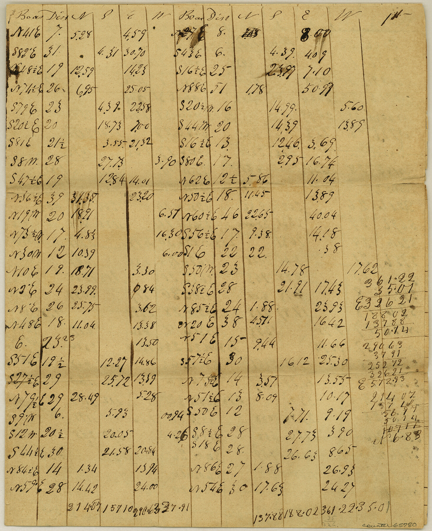
Meanders of Sulphur Fork of Red River, Red River County, Texas
K-3-7
-
Map/Doc
65780
-
Collection
General Map Collection
-
Object Dates
1841 (Creation Date)
-
Counties
Red River
-
Subjects
River Surveys
-
Height x Width
9.9 x 8.0 inches
25.1 x 20.3 cm
Part of: General Map Collection
Cottle County Sketch File 3

Print $4.00
- Digital $50.00
Cottle County Sketch File 3
Size 10.0 x 8.4 inches
Map/Doc 19457
Harrison County Sketch File 2

Print $4.00
- Digital $50.00
Harrison County Sketch File 2
1853
Size 8.1 x 9.9 inches
Map/Doc 26034
Intracoastal Waterway in Texas - Corpus Christi to Point Isabel including Arroyo Colorado to Mo. Pac. R.R. Bridge Near Harlingen

Print $20.00
- Digital $50.00
Intracoastal Waterway in Texas - Corpus Christi to Point Isabel including Arroyo Colorado to Mo. Pac. R.R. Bridge Near Harlingen
1934
Size 21.5 x 32.4 inches
Map/Doc 61883
Hardin County Rolled Sketch 13

Print $20.00
- Digital $50.00
Hardin County Rolled Sketch 13
Size 47.1 x 41.3 inches
Map/Doc 76012
[Sketch for Mineral Application 35811 - Liberty County, John Mecom]
![65619, [Sketch for Mineral Application 35811 - Liberty County, John Mecom], General Map Collection](https://historictexasmaps.com/wmedia_w700/maps/65619.tif.jpg)
Print $4.00
- Digital $50.00
[Sketch for Mineral Application 35811 - Liberty County, John Mecom]
1941
Size 24.9 x 20.0 inches
Map/Doc 65619
Pecos County Working Sketch 68

Print $20.00
- Digital $50.00
Pecos County Working Sketch 68
1955
Size 41.4 x 24.0 inches
Map/Doc 71540
Dawson County Sketch File 28

Print $20.00
- Digital $50.00
Dawson County Sketch File 28
1961
Size 46.0 x 15.3 inches
Map/Doc 10362
Montgomery County Rolled Sketch 26

Print $40.00
- Digital $50.00
Montgomery County Rolled Sketch 26
Size 50.0 x 65.4 inches
Map/Doc 9535
Maps of Gulf Intracoastal Waterway, Texas - Sabine River to the Rio Grande and connecting waterways including ship channels

Print $20.00
- Digital $50.00
Maps of Gulf Intracoastal Waterway, Texas - Sabine River to the Rio Grande and connecting waterways including ship channels
1966
Size 14.6 x 20.5 inches
Map/Doc 62000
[Plat of Location and Right of Way from El Paso, Tex. To New Mexico Line, Rio Grande and El Paso R. R.]
![64084, [Plat of Location and Right of Way from El Paso, Tex. To New Mexico Line, Rio Grande and El Paso R. R.], General Map Collection](https://historictexasmaps.com/wmedia_w700/maps/64084.tif.jpg)
Print $20.00
- Digital $50.00
[Plat of Location and Right of Way from El Paso, Tex. To New Mexico Line, Rio Grande and El Paso R. R.]
Size 22.7 x 46.8 inches
Map/Doc 64084
San Patricio County Working Sketch 26

Print $20.00
- Digital $50.00
San Patricio County Working Sketch 26
1986
Size 29.0 x 34.4 inches
Map/Doc 63788
Colton's New Map of the State of Texas Compiled from J. De Cordova's large Map

Print $20.00
- Digital $50.00
Colton's New Map of the State of Texas Compiled from J. De Cordova's large Map
1859
Size 17.9 x 28.3 inches
Map/Doc 90094
You may also like
Map of Galveston County

Print $20.00
- Digital $50.00
Map of Galveston County
1864
Size 19.6 x 28.0 inches
Map/Doc 3576
Jeff Davis County Working Sketch 37

Print $20.00
- Digital $50.00
Jeff Davis County Working Sketch 37
1979
Size 31.6 x 36.6 inches
Map/Doc 66532
Reeves County Rolled Sketch 20

Print $20.00
- Digital $50.00
Reeves County Rolled Sketch 20
Size 32.1 x 38.4 inches
Map/Doc 9852
Flight Mission No. DQN-2K, Frame 92, Calhoun County

Print $20.00
- Digital $50.00
Flight Mission No. DQN-2K, Frame 92, Calhoun County
1953
Size 18.6 x 22.2 inches
Map/Doc 84282
Flight Mission No. CGI-1N, Frame 219, Cameron County

Print $20.00
- Digital $50.00
Flight Mission No. CGI-1N, Frame 219, Cameron County
1955
Size 18.6 x 22.2 inches
Map/Doc 84528
Working Sketch in Caldwell County

Print $20.00
- Digital $50.00
Working Sketch in Caldwell County
1922
Size 40.2 x 43.3 inches
Map/Doc 93035
Irion County Sketch File 5

Print $16.00
- Digital $50.00
Irion County Sketch File 5
1900
Size 14.4 x 8.9 inches
Map/Doc 27463
Presidio County Working Sketch 45

Print $4.00
- Digital $50.00
Presidio County Working Sketch 45
Size 25.2 x 20.0 inches
Map/Doc 71722
Liberty County Working Sketch 83

Print $40.00
- Digital $50.00
Liberty County Working Sketch 83
1981
Size 68.4 x 37.8 inches
Map/Doc 70543
The Lower Valley of the Rio Grande Irrigated Farm Lands

Print $20.00
- Digital $50.00
The Lower Valley of the Rio Grande Irrigated Farm Lands
1918
Size 24.5 x 18.7 inches
Map/Doc 96730
Brewster County Working Sketch 15a

Print $40.00
- Digital $50.00
Brewster County Working Sketch 15a
1953
Size 22.6 x 49.1 inches
Map/Doc 67549
Current Miscellaneous File 38

Print $8.00
- Digital $50.00
Current Miscellaneous File 38
Size 8.6 x 13.0 inches
Map/Doc 73958