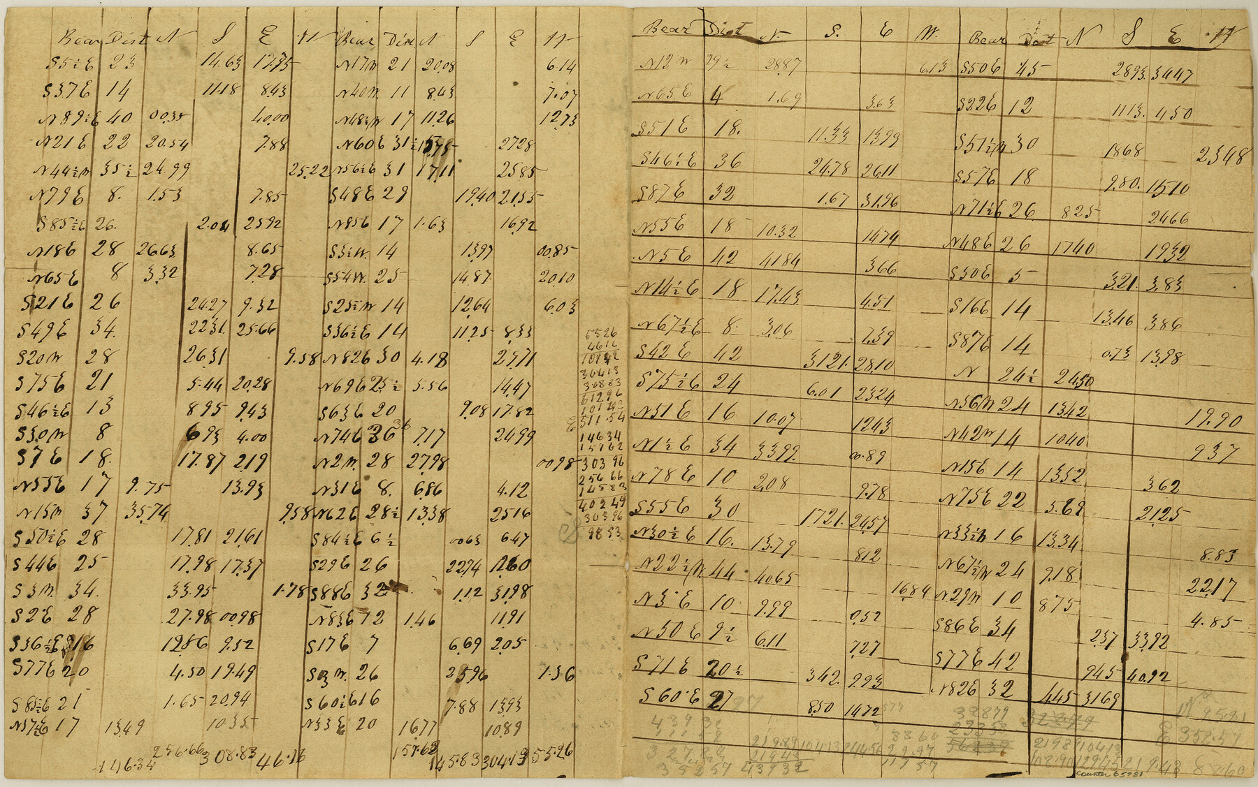
Meanders of Sulphur Fork of Red River, Red River County, Texas
K-3-7
-
Map/Doc
65781
-
Collection
General Map Collection
-
Object Dates
1841 (Creation Date)
-
Counties
Red River
-
Subjects
River Surveys
-
Height x Width
9.9 x 15.8 inches
25.1 x 40.1 cm
Part of: General Map Collection
Current Miscellaneous File 82

Print $4.00
- Digital $50.00
Current Miscellaneous File 82
Size 12.0 x 8.8 inches
Map/Doc 74224
Nueces County Rolled Sketch 56

Print $53.00
- Digital $50.00
Nueces County Rolled Sketch 56
1978
Size 10.0 x 15.1 inches
Map/Doc 47890
United States including territories and insular possessions showing the extent of public surveys, national parks, national forests, indian reservations, national wildlife refuges, and reclamation projects

Print $40.00
- Digital $50.00
United States including territories and insular possessions showing the extent of public surveys, national parks, national forests, indian reservations, national wildlife refuges, and reclamation projects
1953
Size 64.5 x 44.5 inches
Map/Doc 65795
Jeff Davis County Sketch File 18a

Print $14.00
- Digital $50.00
Jeff Davis County Sketch File 18a
Size 9.3 x 6.0 inches
Map/Doc 27966

Wichita County Working Sketch 2

Print $20.00
- Digital $50.00
Wichita County Working Sketch 2
1913
Size 20.0 x 18.7 inches
Map/Doc 72511
Texas Panhandle East Boundary Line

Print $20.00
- Digital $50.00
Texas Panhandle East Boundary Line
Size 37.5 x 8.7 inches
Map/Doc 65381
Brewster County Rolled Sketch 96

Print $20.00
- Digital $50.00
Brewster County Rolled Sketch 96
1951
Size 21.7 x 33.7 inches
Map/Doc 5253
Flight Mission No. DAG-17K, Frame 141, Matagorda County

Print $20.00
- Digital $50.00
Flight Mission No. DAG-17K, Frame 141, Matagorda County
1952
Size 16.3 x 16.4 inches
Map/Doc 86358
Uvalde County Working Sketch 5

Print $20.00
- Digital $50.00
Uvalde County Working Sketch 5
1927
Size 13.4 x 18.0 inches
Map/Doc 72075
St. Louis, Brownsville & Mexico Railway Location Map from Mile 40 to Mile 60

Print $40.00
- Digital $50.00
St. Louis, Brownsville & Mexico Railway Location Map from Mile 40 to Mile 60
1905
Size 20.3 x 136.1 inches
Map/Doc 89282
Potter County Boundary File 4

Print $30.00
- Digital $50.00
Potter County Boundary File 4
Size 14.6 x 9.3 inches
Map/Doc 57997
You may also like
Sutton County Sketch File 49

Print $6.00
- Digital $50.00
Sutton County Sketch File 49
Size 13.6 x 8.9 inches
Map/Doc 37523
Nueces County Rolled Sketch 108

Print $62.00
Nueces County Rolled Sketch 108
1987
Size 18.6 x 23.5 inches
Map/Doc 7112
Map of the Fort Worth & Denver City Railway, Wichita County, Texas

Print $40.00
- Digital $50.00
Map of the Fort Worth & Denver City Railway, Wichita County, Texas
1885
Size 23.7 x 66.5 inches
Map/Doc 64455
Tyler County Working Sketch 10

Print $20.00
- Digital $50.00
Tyler County Working Sketch 10
1937
Size 24.0 x 24.1 inches
Map/Doc 69480
Duval County Rolled Sketch EF

Print $20.00
- Digital $50.00
Duval County Rolled Sketch EF
1934
Size 26.8 x 35.0 inches
Map/Doc 5766
Montgomery County Working Sketch 57

Print $20.00
- Digital $50.00
Montgomery County Working Sketch 57
1961
Size 24.2 x 26.6 inches
Map/Doc 71164
Callahan County Sketch File 3

Print $40.00
- Digital $50.00
Callahan County Sketch File 3
1860
Size 17.4 x 13.8 inches
Map/Doc 35857
Martin County

Print $20.00
- Digital $50.00
Martin County
1933
Size 43.8 x 38.9 inches
Map/Doc 73230
Seymour, Baylor County, Texas

Print $20.00
Seymour, Baylor County, Texas
1890
Size 15.4 x 24.2 inches
Map/Doc 89207
Working Sketch in Bailey County

Print $20.00
- Digital $50.00
Working Sketch in Bailey County
1920
Size 17.1 x 19.1 inches
Map/Doc 90185
Bobalet Heights

Print $20.00
- Digital $50.00
Bobalet Heights
1941
Size 35.6 x 36.5 inches
Map/Doc 92787
Freestone County Working Sketch 12

Print $40.00
- Digital $50.00
Freestone County Working Sketch 12
1980
Size 54.5 x 38.6 inches
Map/Doc 69254