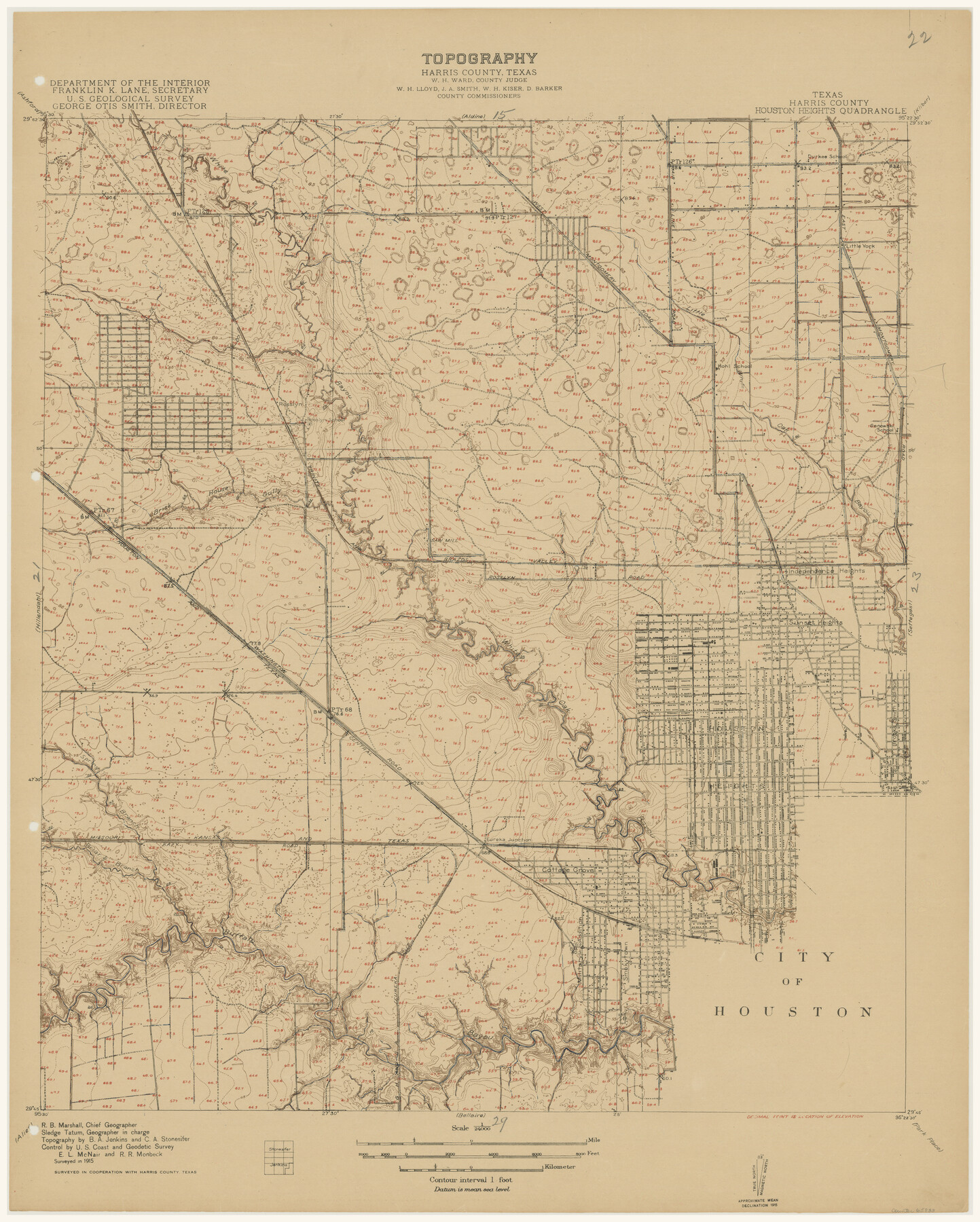
Harris County Historic Topographic 22
Houston Heights Quadrangle
-
Map/Doc
65833
-
Collection
General Map Collection
-
Object Dates
1915 (Creation Date)
-
People and Organizations
U. S. Geological Survey (Publisher)
-
Counties
Harris
-
Subjects
Topographic
-
Height x Width
29.2 x 22.7 inches
74.2 x 57.7 cm
Part of: General Map Collection
Lipscomb County Rolled Sketch 1

Print $40.00
- Digital $50.00
Lipscomb County Rolled Sketch 1
Size 65.0 x 15.8 inches
Map/Doc 9449
Colorado County Working Sketch 33

Print $20.00
- Digital $50.00
Colorado County Working Sketch 33
1988
Size 38.7 x 32.4 inches
Map/Doc 68133
[Galveston, Harrisburg & San Antonio through El Paso County]
![64001, [Galveston, Harrisburg & San Antonio through El Paso County], General Map Collection](https://historictexasmaps.com/wmedia_w700/maps/64001.tif.jpg)
Print $20.00
- Digital $50.00
[Galveston, Harrisburg & San Antonio through El Paso County]
1907
Size 13.6 x 33.7 inches
Map/Doc 64001
Travis County Rolled Sketch 34

Print $20.00
- Digital $50.00
Travis County Rolled Sketch 34
1949
Size 22.9 x 25.2 inches
Map/Doc 8035
Brazoria County Sketch File 38

Print $40.00
- Digital $50.00
Brazoria County Sketch File 38
1917
Size 17.1 x 14.5 inches
Map/Doc 15043
Texas-Indian Territory Gainesville Quadrangle

Print $20.00
- Digital $50.00
Texas-Indian Territory Gainesville Quadrangle
1913
Size 20.4 x 16.9 inches
Map/Doc 75103
Angelina County Working Sketch 40

Print $20.00
- Digital $50.00
Angelina County Working Sketch 40
1960
Size 14.2 x 18.8 inches
Map/Doc 67123
Colorado County Working Sketch 10

Print $20.00
- Digital $50.00
Colorado County Working Sketch 10
1940
Size 23.2 x 24.4 inches
Map/Doc 68110
Harrison County Working Sketch 18

Print $20.00
- Digital $50.00
Harrison County Working Sketch 18
1976
Size 37.0 x 40.1 inches
Map/Doc 66038
Surveyor's Watercourse Report 1

Print $34.00
Surveyor's Watercourse Report 1
2025
Size 11.0 x 8.5 inches
Map/Doc 97511
Cameron County Rolled Sketch 31

Print $20.00
- Digital $50.00
Cameron County Rolled Sketch 31
1993
Size 18.4 x 24.3 inches
Map/Doc 5395
Garza County Working Sketch 13

Print $20.00
- Digital $50.00
Garza County Working Sketch 13
1956
Size 19.0 x 12.7 inches
Map/Doc 63160
You may also like
Colorado County Working Sketch 16

Print $20.00
- Digital $50.00
Colorado County Working Sketch 16
1950
Size 23.3 x 19.6 inches
Map/Doc 68116
Webb County Working Sketch 80

Print $40.00
- Digital $50.00
Webb County Working Sketch 80
1979
Size 43.0 x 97.9 inches
Map/Doc 72447
Map of Texas and New Orleans R.R. or Sabine and Galveston Bay Rail Road

Print $40.00
- Digital $50.00
Map of Texas and New Orleans R.R. or Sabine and Galveston Bay Rail Road
1859
Size 17.0 x 59.1 inches
Map/Doc 64091
Outline Map showing a New Route from Texas to Fort Yuma, California for Cattle Droves and Trains En route to California

Print $40.00
- Digital $50.00
Outline Map showing a New Route from Texas to Fort Yuma, California for Cattle Droves and Trains En route to California
1880
Size 17.5 x 52.2 inches
Map/Doc 97141
Flight Mission No. BRA-9M, Frame 75, Jefferson County

Print $20.00
- Digital $50.00
Flight Mission No. BRA-9M, Frame 75, Jefferson County
1953
Size 18.6 x 22.5 inches
Map/Doc 85658
Bexar County Rolled Sketch 4

Print $20.00
- Digital $50.00
Bexar County Rolled Sketch 4
Size 24.3 x 36.8 inches
Map/Doc 5137
Chambers County Rolled Sketch FD

Print $20.00
- Digital $50.00
Chambers County Rolled Sketch FD
1935
Size 32.7 x 26.5 inches
Map/Doc 5433
Travis County Appraisal District Plat Map 2_3013

Print $20.00
- Digital $50.00
Travis County Appraisal District Plat Map 2_3013
Size 21.5 x 26.4 inches
Map/Doc 94220
Wharton County Working Sketch 24

Print $20.00
- Digital $50.00
Wharton County Working Sketch 24
1909
Size 13.3 x 14.2 inches
Map/Doc 72488
McLennan County Boundary File 1

Print $80.00
- Digital $50.00
McLennan County Boundary File 1
Size 19.4 x 12.3 inches
Map/Doc 56937
Current Miscellaneous File 94

Print $3.00
- Digital $50.00
Current Miscellaneous File 94
1851
Size 11.2 x 17.1 inches
Map/Doc 74268
Trinity County

Print $20.00
- Digital $50.00
Trinity County
1946
Size 42.5 x 42.8 inches
Map/Doc 73306