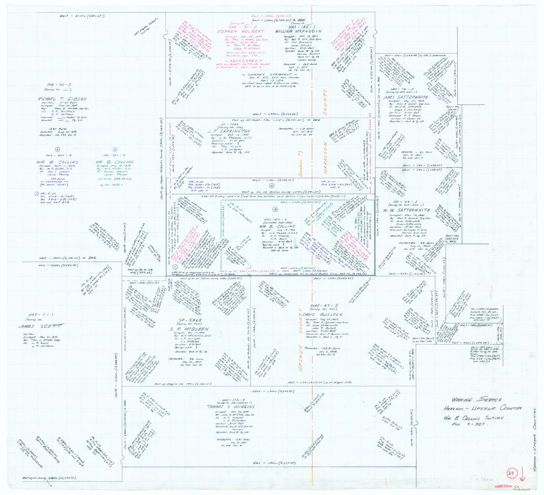
Harrison County Working Sketch 29
-
Map/Doc
66049
-
Collection
General Map Collection
-
Counties
Harrison Upshur
-
Subjects
Surveying Working Sketch
-
Height x Width
33.7 x 37.0 inches
85.6 x 94.0 cm
Part of: General Map Collection
Goliad County Sketch File 19

Print $10.00
- Digital $50.00
Goliad County Sketch File 19
Size 12.9 x 8.0 inches
Map/Doc 24260
Liberty County Working Sketch 35

Print $20.00
- Digital $50.00
Liberty County Working Sketch 35
1948
Size 22.3 x 42.3 inches
Map/Doc 70494
Map of Webb Co.

Print $20.00
- Digital $50.00
Map of Webb Co.
1901
Size 40.4 x 47.1 inches
Map/Doc 16919
San Augustine County Working Sketch 12

Print $20.00
- Digital $50.00
San Augustine County Working Sketch 12
1951
Size 29.0 x 21.0 inches
Map/Doc 63700
Comal County Rolled Sketch 2

Print $20.00
- Digital $50.00
Comal County Rolled Sketch 2
Size 21.6 x 13.0 inches
Map/Doc 5536
Uvalde County Sketch File 28

Print $10.00
- Digital $50.00
Uvalde County Sketch File 28
1980
Size 14.8 x 8.9 inches
Map/Doc 39023
Map of Robertson District

Print $40.00
- Digital $50.00
Map of Robertson District
1846
Size 81.3 x 45.3 inches
Map/Doc 3032
Map of Surveys Made for the T&PRR in Borden, Dawson, Howard & Martin Counties, Blocks 32, 33, 34, 35 & 36, Reserve West of the Colorado

Print $20.00
- Digital $50.00
Map of Surveys Made for the T&PRR in Borden, Dawson, Howard & Martin Counties, Blocks 32, 33, 34, 35 & 36, Reserve West of the Colorado
1876
Size 42.0 x 38.2 inches
Map/Doc 2231
Reagan County Sketch File RB

Print $8.00
- Digital $50.00
Reagan County Sketch File RB
Size 11.3 x 9.0 inches
Map/Doc 34996
Tarrant County Rolled Sketch 4

Print $20.00
- Digital $50.00
Tarrant County Rolled Sketch 4
1982
Size 27.2 x 19.2 inches
Map/Doc 7912
Upton County Rolled Sketch 43

Print $40.00
- Digital $50.00
Upton County Rolled Sketch 43
Size 27.1 x 54.2 inches
Map/Doc 10057
Topographical Map of the Rio Grande, Sheet No. 28

Print $20.00
- Digital $50.00
Topographical Map of the Rio Grande, Sheet No. 28
1912
Map/Doc 89552
You may also like
Victoria County Working Sketch 9

Print $40.00
- Digital $50.00
Victoria County Working Sketch 9
1963
Size 49.9 x 35.8 inches
Map/Doc 72279
Flight Mission No. DAG-28K, Frame 29, Matagorda County

Print $20.00
- Digital $50.00
Flight Mission No. DAG-28K, Frame 29, Matagorda County
1953
Size 16.2 x 16.1 inches
Map/Doc 86597

Crockett County Working Sketch 4

Print $40.00
- Digital $50.00
Crockett County Working Sketch 4
Size 26.8 x 70.4 inches
Map/Doc 68337
Throckmorton Co.

Print $20.00
- Digital $50.00
Throckmorton Co.
1898
Size 41.7 x 36.7 inches
Map/Doc 63064
Nueces County Sketch File 12c

Print $11.00
- Digital $50.00
Nueces County Sketch File 12c
1889
Size 12.6 x 8.2 inches
Map/Doc 32534
Palo Pinto County Sketch File 26

Print $8.00
- Digital $50.00
Palo Pinto County Sketch File 26
1993
Size 14.0 x 8.6 inches
Map/Doc 33441
Real County Working Sketch 86

Print $20.00
- Digital $50.00
Real County Working Sketch 86
1988
Size 37.8 x 26.6 inches
Map/Doc 71978
Hardeman County Working Sketch 18

Print $20.00
- Digital $50.00
Hardeman County Working Sketch 18
2002
Size 33.5 x 36.5 inches
Map/Doc 76401
Flight Mission No. DQO-8K, Frame 45, Galveston County

Print $20.00
- Digital $50.00
Flight Mission No. DQO-8K, Frame 45, Galveston County
1952
Size 18.8 x 22.3 inches
Map/Doc 85152
Terry County Sketch File 17

Print $5.00
- Digital $50.00
Terry County Sketch File 17
1956
Size 27.7 x 24.7 inches
Map/Doc 12429
Schleicher County Working Sketch 10

Print $20.00
- Digital $50.00
Schleicher County Working Sketch 10
1923
Size 18.3 x 16.4 inches
Map/Doc 63812