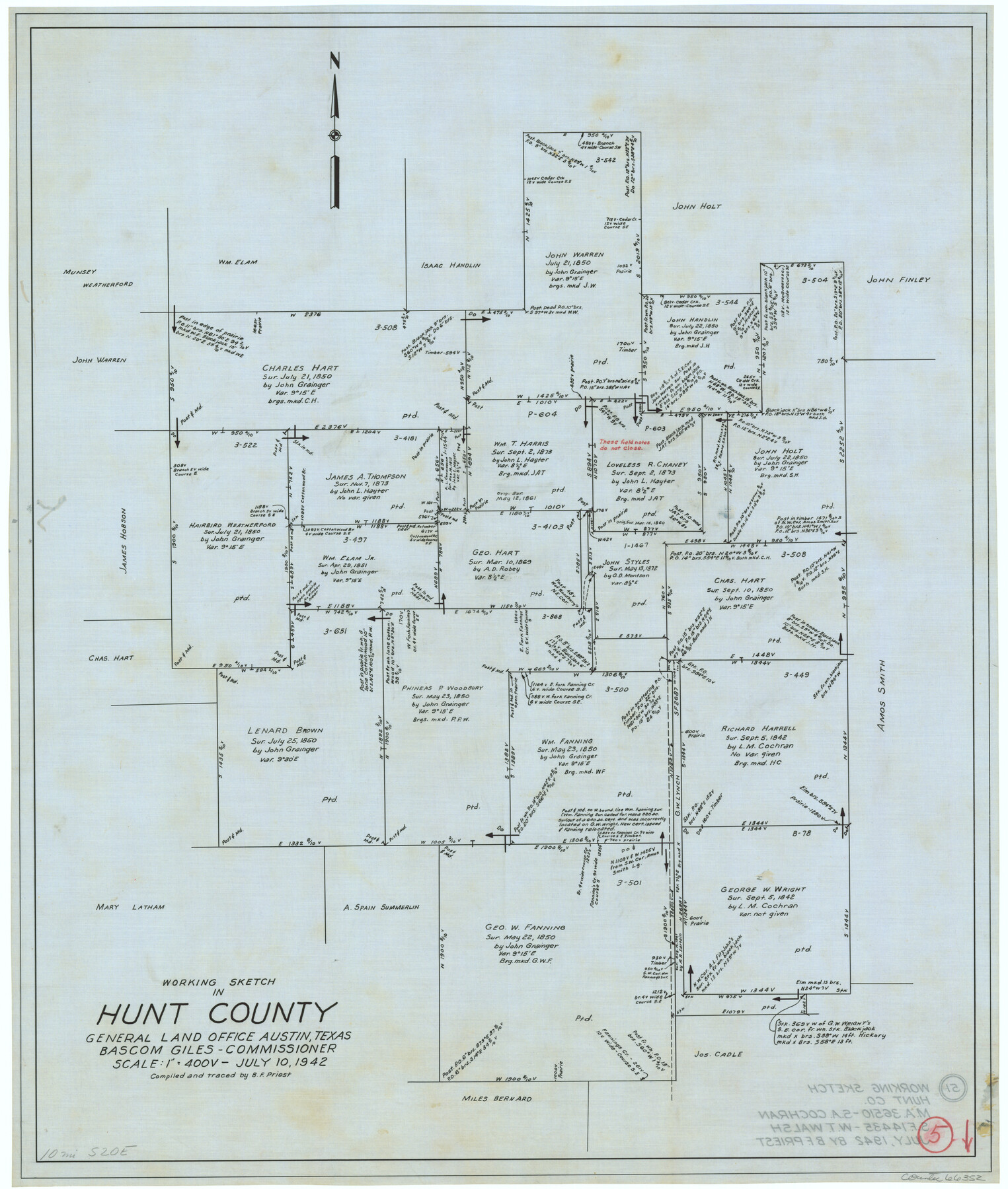
Hunt County Working Sketch 5
-
Map/Doc
66352
-
Collection
General Map Collection
-
Object Dates
7/10/1942 (Creation Date)
-
People and Organizations
B.F. Priest (Draftsman)
-
Counties
Hunt
-
Subjects
Surveying Working Sketch
-
Height x Width
23.8 x 20.2 inches
60.5 x 51.3 cm
-
Scale
1" = 400 varas
Part of: General Map Collection
Webb County Sketch File 20

Print $4.00
- Digital $50.00
Webb County Sketch File 20
Size 8.8 x 14.4 inches
Map/Doc 39827
Marion County Rolled Sketch 3

Print $20.00
- Digital $50.00
Marion County Rolled Sketch 3
1955
Size 35.4 x 35.5 inches
Map/Doc 9490
Schleicher County Sketch File 42

Print $40.00
- Digital $50.00
Schleicher County Sketch File 42
1963
Size 16.3 x 14.4 inches
Map/Doc 36546
Waller County Working Sketch 6

Print $20.00
- Digital $50.00
Waller County Working Sketch 6
1988
Size 31.1 x 20.0 inches
Map/Doc 72305
Aransas County Sketch File 22

Print $34.00
- Digital $50.00
Aransas County Sketch File 22
1910
Size 14.8 x 9.1 inches
Map/Doc 13166

Duval County Sketch File 20

Print $20.00
- Digital $50.00
Duval County Sketch File 20
1880
Size 17.9 x 14.6 inches
Map/Doc 11384
Flight Mission No. DCL-5C, Frame 28, Kenedy County

Print $20.00
- Digital $50.00
Flight Mission No. DCL-5C, Frame 28, Kenedy County
1943
Size 18.5 x 22.3 inches
Map/Doc 85840
Cherokee County Sketch File 26

Print $4.00
- Digital $50.00
Cherokee County Sketch File 26
1852
Size 8.1 x 8.2 inches
Map/Doc 18169
San Patricio County Rolled Sketch 39

Print $20.00
- Digital $50.00
San Patricio County Rolled Sketch 39
1961
Size 40.4 x 31.7 inches
Map/Doc 7725
Fort Bend County Boundary File 4

Print $40.00
- Digital $50.00
Fort Bend County Boundary File 4
Size 18.5 x 26.2 inches
Map/Doc 53567
Kinney County Rolled Sketch 13

Print $20.00
- Digital $50.00
Kinney County Rolled Sketch 13
1949
Size 24.9 x 37.4 inches
Map/Doc 77562
You may also like
Limestone County Sketch File 25

Print $20.00
- Digital $50.00
Limestone County Sketch File 25
Size 25.1 x 32.8 inches
Map/Doc 12003
Pecos County Working Sketch 47

Print $20.00
- Digital $50.00
Pecos County Working Sketch 47
1947
Size 19.2 x 21.9 inches
Map/Doc 71519
Flight Mission No. CLL-4N, Frame 33, Willacy County

Print $20.00
- Digital $50.00
Flight Mission No. CLL-4N, Frame 33, Willacy County
1954
Size 18.3 x 22.0 inches
Map/Doc 87106
Part of Matagorda Bay & Peninsula, Texas

Print $40.00
- Digital $50.00
Part of Matagorda Bay & Peninsula, Texas
1856
Size 31.8 x 51.4 inches
Map/Doc 69978
Crockett County Rolled Sketch 46C

Print $20.00
- Digital $50.00
Crockett County Rolled Sketch 46C
Size 24.5 x 23.8 inches
Map/Doc 5595
Stonewall County Sketch File 12 and 12a

Print $30.00
- Digital $50.00
Stonewall County Sketch File 12 and 12a
1900
Size 9.2 x 9.0 inches
Map/Doc 37240
Hartley County Sketch File 18

Print $4.00
- Digital $50.00
Hartley County Sketch File 18
2001
Size 11.1 x 8.7 inches
Map/Doc 76330
San Jacinto County Working Sketch 9
Print $20.00
- Digital $50.00
San Jacinto County Working Sketch 9
1935
Size 36.1 x 42.1 inches
Map/Doc 63722
[Oceani occidentalis seu terrae novae tabula]
![95835, [Oceani occidentalis seu Terre Noue Tabula Christophorus Columbus], General Map Collection](https://historictexasmaps.com/wmedia_w700/maps/95835-1.tif.jpg)
Print $20.00
- Digital $50.00
[Oceani occidentalis seu terrae novae tabula]
1535
Size 16.0 x 21.6 inches
Map/Doc 95835
Trinity County

Print $20.00
- Digital $50.00
Trinity County
1946
Size 42.7 x 43.2 inches
Map/Doc 95656
Brazos County Sketch File 3

Print $6.00
- Digital $50.00
Brazos County Sketch File 3
1861
Size 11.1 x 8.0 inches
Map/Doc 15554
Flight Mission No. DQN-2K, Frame 64, Calhoun County

Print $20.00
- Digital $50.00
Flight Mission No. DQN-2K, Frame 64, Calhoun County
1953
Size 18.6 x 22.3 inches
Map/Doc 84256