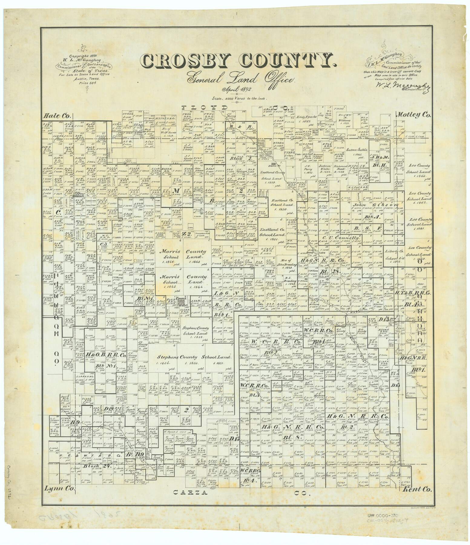
Crosby Co.
-
Map/Doc
66794
-
Collection
General Map Collection
-
Object Dates
1892 (Creation Date)
-
People and Organizations
Texas General Land Office (Publisher)
W.L. McGaughey (GLO Commissioner)
-
Counties
Crosby
-
Subjects
County
-
Height x Width
23.9 x 20.6 inches
60.7 x 52.3 cm
-
Comments
Copyrighted 1891.
Part of: General Map Collection
Map of Castro County

Print $20.00
- Digital $50.00
Map of Castro County
1900
Size 41.9 x 34.4 inches
Map/Doc 4748
South Part of Webb County

Print $40.00
- Digital $50.00
South Part of Webb County
1984
Size 41.2 x 61.5 inches
Map/Doc 77453
[Surveys in the Bexar District along the Sabinal and Frio Rivers]
![3167, [Surveys in the Bexar District along the Sabinal and Frio Rivers], General Map Collection](https://historictexasmaps.com/wmedia_w700/maps/3167.tif.jpg)
Print $20.00
- Digital $50.00
[Surveys in the Bexar District along the Sabinal and Frio Rivers]
1846
Size 16.8 x 19.6 inches
Map/Doc 3167
Anderson County Working Sketch 31

Print $20.00
- Digital $50.00
Anderson County Working Sketch 31
1966
Size 18.3 x 23.2 inches
Map/Doc 67031
Map of Taylor, Bastrop & Houston Railroad in Williamson, Travis, & Bastrop Counties, Texas

Print $20.00
- Digital $50.00
Map of Taylor, Bastrop & Houston Railroad in Williamson, Travis, & Bastrop Counties, Texas
1887
Size 26.3 x 17.8 inches
Map/Doc 65468
Part of Laguna Madre in Nueces and Kleberg Counties, showing Subdivision for Mineral Development

Print $20.00
- Digital $50.00
Part of Laguna Madre in Nueces and Kleberg Counties, showing Subdivision for Mineral Development
1948
Size 42.0 x 30.3 inches
Map/Doc 1921
Flight Mission No. BRE-5P, Frame 201, Nueces County

Print $20.00
- Digital $50.00
Flight Mission No. BRE-5P, Frame 201, Nueces County
1956
Size 18.5 x 22.6 inches
Map/Doc 86841
Chocolate Bayou, Texas showing proposed connection from its mouth to West Galveston Bay for a Light Draft Navigation

Print $20.00
- Digital $50.00
Chocolate Bayou, Texas showing proposed connection from its mouth to West Galveston Bay for a Light Draft Navigation
Size 13.2 x 20.4 inches
Map/Doc 96557
Shackelford County Boundary File 7b

Print $90.00
- Digital $50.00
Shackelford County Boundary File 7b
Size 7.9 x 10.4 inches
Map/Doc 58692
Eastland County Sketch File 1

Print $8.00
- Digital $50.00
Eastland County Sketch File 1
Size 9.0 x 7.9 inches
Map/Doc 21555
Galveston County Aerial Photograph Index Sheet 3

Print $20.00
- Digital $50.00
Galveston County Aerial Photograph Index Sheet 3
1953
Size 22.2 x 19.2 inches
Map/Doc 83694
Harris County Sketch File 107

Print $18.00
- Digital $50.00
Harris County Sketch File 107
1996
Size 11.2 x 8.7 inches
Map/Doc 26015
You may also like
McLennan County Sketch File 35

Print $10.00
- Digital $50.00
McLennan County Sketch File 35
Size 13.1 x 8.1 inches
Map/Doc 31310
Map of Trinity Co.

Print $20.00
- Digital $50.00
Map of Trinity Co.
1896
Size 41.3 x 38.3 inches
Map/Doc 78446
Dawson County Rolled Sketch 10

Print $20.00
- Digital $50.00
Dawson County Rolled Sketch 10
1954
Size 44.5 x 37.9 inches
Map/Doc 8774
Limestone County Sketch File 11

Print $4.00
- Digital $50.00
Limestone County Sketch File 11
1881
Size 7.9 x 9.5 inches
Map/Doc 30177
Leon County Rolled Sketch 27A

Print $40.00
- Digital $50.00
Leon County Rolled Sketch 27A
Size 50.5 x 47.8 inches
Map/Doc 9437
Baylor County Boundary File 9

Print $4.00
- Digital $50.00
Baylor County Boundary File 9
Size 11.2 x 8.7 inches
Map/Doc 50407
Bexar County Sketch File 49

Print $8.00
- Digital $50.00
Bexar County Sketch File 49
1874
Size 12.6 x 8.3 inches
Map/Doc 14530
Spanish land grants (other than porciones) in the trans-Nueces

Spanish land grants (other than porciones) in the trans-Nueces
2009
Size 11.0 x 8.5 inches
Map/Doc 94046
Trinity River, Clapps Ferry Sheet

Print $20.00
- Digital $50.00
Trinity River, Clapps Ferry Sheet
1925
Size 47.5 x 36.4 inches
Map/Doc 65180
Austin's Register of Families Vol. 2

Austin's Register of Families Vol. 2
Size 13.6 x 10.1 inches
Map/Doc 94250
[Capitol Leagues, Blocks 49 H. & T. C. RR. Company, Block LC2]
![90769, [Capitol Leagues, Blocks 49 H. & T. C. RR. Company, Block LC2], Twichell Survey Records](https://historictexasmaps.com/wmedia_w700/maps/90769-1.tif.jpg)
Print $20.00
- Digital $50.00
[Capitol Leagues, Blocks 49 H. & T. C. RR. Company, Block LC2]
1883
Size 39.2 x 24.8 inches
Map/Doc 90769
Newton County Working Sketch 28

Print $40.00
- Digital $50.00
Newton County Working Sketch 28
1954
Size 34.7 x 55.0 inches
Map/Doc 71274