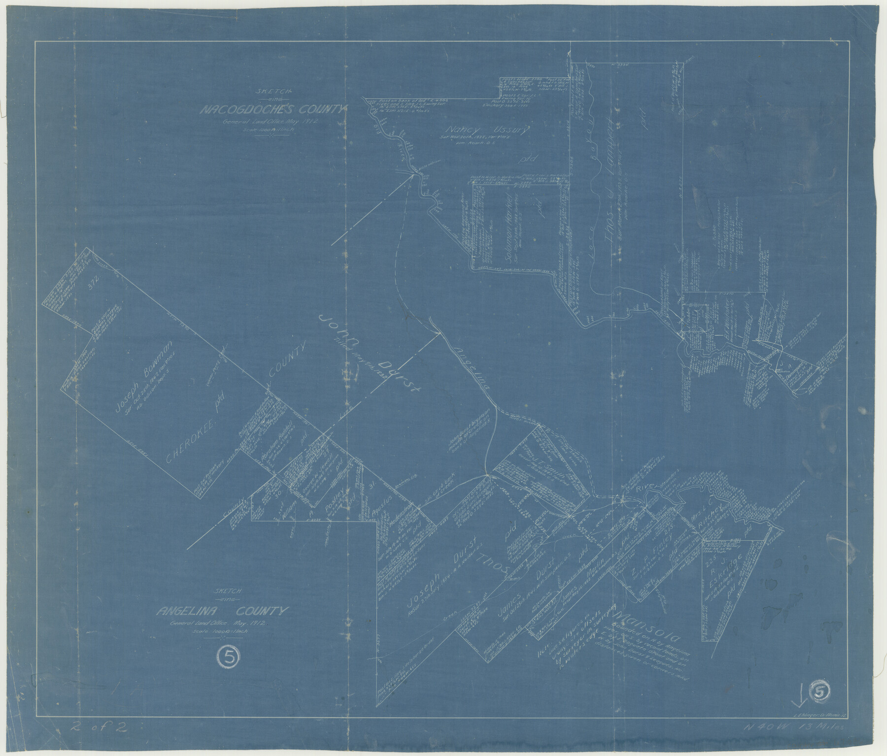
Nacogdoches County Working Sketch 13
-
Map/Doc
67086
-
Collection
General Map Collection
-
Object Dates
5/1912 (Creation Date)
-
People and Organizations
L. Ehlinger (Draftsman)
-
Counties
Nacogdoches Angelina
-
Subjects
Surveying Working Sketch
-
Height x Width
22.6 x 26.5 inches
57.4 x 67.3 cm
-
Scale
1" = 1000 varas
-
Comments
Surveys located about 11 miles South 63 degrees West from Rusk, Texas.
Part of: General Map Collection
Map of Walker County

Print $20.00
- Digital $50.00
Map of Walker County
1858
Size 22.9 x 34.1 inches
Map/Doc 4120
Culberson County Sketch File 4a

Print $10.00
- Digital $50.00
Culberson County Sketch File 4a
Size 9.2 x 7.9 inches
Map/Doc 20131
Irion County Boundary File 1

Print $36.00
- Digital $50.00
Irion County Boundary File 1
Size 8.9 x 4.1 inches
Map/Doc 55316
Rusk County Sketch File 19a

Print $4.00
Rusk County Sketch File 19a
1860
Size 8.2 x 6.6 inches
Map/Doc 35528
Shelby County Rolled Sketch 5

Print $20.00
- Digital $50.00
Shelby County Rolled Sketch 5
1942
Size 37.9 x 43.7 inches
Map/Doc 9921
Zapata County

Print $40.00
- Digital $50.00
Zapata County
1935
Size 56.7 x 43.2 inches
Map/Doc 63145
Harrison County Working Sketch 3

Print $20.00
- Digital $50.00
Harrison County Working Sketch 3
1942
Size 43.8 x 19.0 inches
Map/Doc 66023
Hutchinson County Rolled Sketch 44-13

Print $20.00
- Digital $50.00
Hutchinson County Rolled Sketch 44-13
2002
Size 24.0 x 36.0 inches
Map/Doc 77549
Medina County Working Sketch 29

Print $20.00
- Digital $50.00
Medina County Working Sketch 29
Size 40.1 x 25.0 inches
Map/Doc 70944
Parker County

Print $20.00
- Digital $50.00
Parker County
1942
Size 45.7 x 37.8 inches
Map/Doc 66972
No. 2 Chart of Corpus Christi Pass, Texas

Print $20.00
- Digital $50.00
No. 2 Chart of Corpus Christi Pass, Texas
1878
Size 18.2 x 27.3 inches
Map/Doc 73027
Panola County Sketch File 8

Print $4.00
- Digital $50.00
Panola County Sketch File 8
1862
Size 12.8 x 7.8 inches
Map/Doc 33459
You may also like
Cass County Rolled Sketch BRR

Print $40.00
- Digital $50.00
Cass County Rolled Sketch BRR
1936
Size 67.3 x 28.0 inches
Map/Doc 8581
Duval County Rolled Sketch 44A

Print $40.00
- Digital $50.00
Duval County Rolled Sketch 44A
1981
Size 37.8 x 91.9 inches
Map/Doc 9062
Flight Mission No. BQR-7K, Frame 26, Brazoria County

Print $20.00
- Digital $50.00
Flight Mission No. BQR-7K, Frame 26, Brazoria County
1952
Size 18.7 x 22.3 inches
Map/Doc 84024
[Surveys along Cypress Creek]
![155, [Surveys along Cypress Creek], General Map Collection](https://historictexasmaps.com/wmedia_w700/maps/155.tif.jpg)
Print $2.00
- Digital $50.00
[Surveys along Cypress Creek]
1844
Size 6.0 x 6.1 inches
Map/Doc 155
Flight Mission No. BRA-16M, Frame 137, Jefferson County

Print $20.00
- Digital $50.00
Flight Mission No. BRA-16M, Frame 137, Jefferson County
1953
Size 18.7 x 22.3 inches
Map/Doc 85743
Right of Way and Track Map, Houston & Texas Central R.R. operated by the T. and N. O. R.R., Fort Worth Branch

Print $40.00
- Digital $50.00
Right of Way and Track Map, Houston & Texas Central R.R. operated by the T. and N. O. R.R., Fort Worth Branch
1918
Size 30.7 x 57.3 inches
Map/Doc 64782
Coke County Sketch File AB

Print $12.00
- Digital $50.00
Coke County Sketch File AB
1884
Size 14.1 x 8.7 inches
Map/Doc 18608
Pecos County Rolled Sketch 122

Print $20.00
- Digital $50.00
Pecos County Rolled Sketch 122
1945
Size 32.5 x 39.1 inches
Map/Doc 7263
El Paso County Working Sketch 42

Print $20.00
- Digital $50.00
El Paso County Working Sketch 42
Size 24.6 x 26.6 inches
Map/Doc 69064
Amistad International Reservoir on Rio Grande 84

Print $20.00
- Digital $50.00
Amistad International Reservoir on Rio Grande 84
1949
Size 28.4 x 40.2 inches
Map/Doc 75513
Map of Washington County

Print $20.00
- Digital $50.00
Map of Washington County
1841
Size 28.5 x 29.0 inches
Map/Doc 4122
Outer Continental Shelf Leasing Maps (Louisiana Offshore Operations)

Print $20.00
- Digital $50.00
Outer Continental Shelf Leasing Maps (Louisiana Offshore Operations)
1955
Size 19.9 x 13.4 inches
Map/Doc 75860