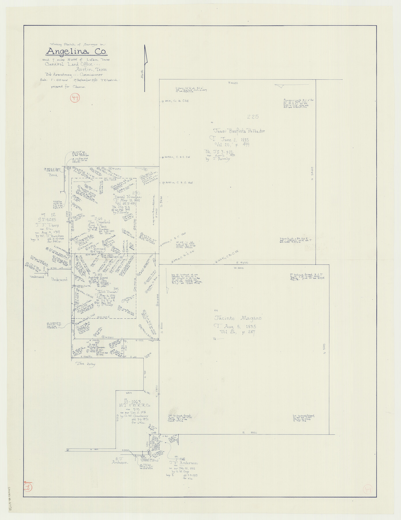
Angelina County Working Sketch 49
-
Map/Doc
67132
-
Collection
General Map Collection
-
Object Dates
9/17/1980 (Creation Date)
-
People and Organizations
Joan Kilpatrick (Draftsman)
Bob Armstrong (GLO Commissioner)
-
Counties
Angelina
-
Subjects
Surveying Working Sketch
-
Height x Width
38.2 x 29.5 inches
97.0 x 74.9 cm
-
Scale
1" = 400 varas
-
Comments
Surveys located about seven miles North 60 degrees West from Lufkin, Texas.
Part of: General Map Collection
Duval County Rolled Sketch 42

Print $20.00
- Digital $50.00
Duval County Rolled Sketch 42
1973
Size 23.6 x 29.8 inches
Map/Doc 5759
Johnson County Working Sketch 16

Print $20.00
- Digital $50.00
Johnson County Working Sketch 16
1981
Size 37.3 x 38.0 inches
Map/Doc 66629
Flight Mission No. BRE-4P, Frame 168, Nueces County

Print $20.00
- Digital $50.00
Flight Mission No. BRE-4P, Frame 168, Nueces County
1956
Size 18.7 x 22.6 inches
Map/Doc 86831
Lipscomb County Rolled Sketch 7

Print $20.00
- Digital $50.00
Lipscomb County Rolled Sketch 7
1968
Size 23.6 x 23.4 inches
Map/Doc 6630
Lipscomb County Boundary File 14b

Print $60.00
- Digital $50.00
Lipscomb County Boundary File 14b
Size 7.3 x 8.7 inches
Map/Doc 56370
Donley County Sketch File 23

Print $4.00
- Digital $50.00
Donley County Sketch File 23
Size 8.4 x 14.5 inches
Map/Doc 21258
Smith County Rolled Sketch 6B

Print $40.00
- Digital $50.00
Smith County Rolled Sketch 6B
1949
Size 91.7 x 38.5 inches
Map/Doc 10700
Val Verde County Working Sketch 107

Print $20.00
- Digital $50.00
Val Verde County Working Sketch 107
Size 32.8 x 43.5 inches
Map/Doc 72242
Tyler County Rolled Sketch 7

Print $20.00
- Digital $50.00
Tyler County Rolled Sketch 7
1960
Size 40.0 x 46.5 inches
Map/Doc 10030
Jefferson County

Print $20.00
- Digital $50.00
Jefferson County
1882
Size 22.8 x 20.0 inches
Map/Doc 3730
Fort Bend County State Real Property Sketch 15

Print $20.00
- Digital $50.00
Fort Bend County State Real Property Sketch 15
1985
Size 34.9 x 43.5 inches
Map/Doc 61689
Flight Mission No. DAG-21K, Frame 34, Matagorda County

Print $20.00
- Digital $50.00
Flight Mission No. DAG-21K, Frame 34, Matagorda County
1952
Size 18.7 x 22.3 inches
Map/Doc 86401
You may also like
Aransas Pass to Baffin Bay

Print $20.00
- Digital $50.00
Aransas Pass to Baffin Bay
1986
Size 44.7 x 35.7 inches
Map/Doc 73421
Reeves County Rolled Sketch 25

Print $20.00
- Digital $50.00
Reeves County Rolled Sketch 25
1982
Size 22.3 x 20.6 inches
Map/Doc 7494
Flight Mission No. BRA-16M, Frame 166, Jefferson County

Print $20.00
- Digital $50.00
Flight Mission No. BRA-16M, Frame 166, Jefferson County
1953
Size 18.5 x 22.3 inches
Map/Doc 85764
Presidio County Rolled Sketch D

Print $20.00
- Digital $50.00
Presidio County Rolled Sketch D
Size 13.7 x 22.4 inches
Map/Doc 7408
[H.& G.N. Block B3 in NE corner of County]
![90272, [H.& G.N. Block B3 in NE corner of County], Twichell Survey Records](https://historictexasmaps.com/wmedia_w700/maps/90272-1.tif.jpg)
Print $3.00
- Digital $50.00
[H.& G.N. Block B3 in NE corner of County]
Size 13.8 x 9.7 inches
Map/Doc 90272
Flight Mission No. DQN-2K, Frame 114, Calhoun County

Print $20.00
- Digital $50.00
Flight Mission No. DQN-2K, Frame 114, Calhoun County
1953
Size 18.5 x 22.2 inches
Map/Doc 84290
J.K Gill & Cos Map of Oregon

Print $20.00
- Digital $50.00
J.K Gill & Cos Map of Oregon
1882
Size 29.0 x 32.3 inches
Map/Doc 94055
Kimble County Working Sketch 94

Print $20.00
- Digital $50.00
Kimble County Working Sketch 94
1993
Size 28.3 x 33.7 inches
Map/Doc 70162
Pecos County Working Sketch 102

Print $40.00
- Digital $50.00
Pecos County Working Sketch 102
1971
Size 36.9 x 52.7 inches
Map/Doc 71575
Sutton County Boundary File 6

Print $10.00
- Digital $50.00
Sutton County Boundary File 6
Size 14.4 x 8.8 inches
Map/Doc 59070
Travis County Appraisal District Plat Map 2_2011

Print $20.00
- Digital $50.00
Travis County Appraisal District Plat Map 2_2011
Size 21.4 x 26.4 inches
Map/Doc 94211
[Surveys in the Bexar District along the Cibolo Creek]
![98, [Surveys in the Bexar District along the Cibolo Creek], General Map Collection](https://historictexasmaps.com/wmedia_w700/maps/98.tif.jpg)
Print $2.00
- Digital $50.00
[Surveys in the Bexar District along the Cibolo Creek]
1847
Size 13.0 x 7.4 inches
Map/Doc 98